Trail Walking Samoëns - Bostan  Golèse  - Photo
© OpenStreetMap contributors
Length
Length
10.1 km
Max alt
Max alt
1809 m
Uphill gradient
Uphill gradient
634 m
Km-Effort
Km-Effort  
18.8 km
Min alt
Min alt
1110 m
Downhill gradient
Downhill gradient
714 m
Boucle
Boucle
No
Creation date :
2020-07-02 07:05:28.049
Updated on :
2020-07-02 13:32:11.867

(0 Reviews)

Walking
Walking
5h22
Difficulty : Medium

Scan this QR Code to open this trail in the SityTrail application

FREE GPS app for hiking

Logo SityTrail SityTrail

IGN / Geographical institutes

Download SityTrail from the App Store Download SityTrail from Google Play

Logo SityTrail SityTrail World

The world is yours!

Download SityTrail from the App Store Download SityTrail from Google Play Download SityTrail on Huawei AppGallery

About

Trail Walking of 10.1 km to be discovered at Auvergne-Rhône-Alpes, Upper Savoy, Samoëns. This trail is proposed by pensionisten71.

Description

Départ des Allamands
le GPS n'était pas ouvert au début de la rando
garder le sens de la rando

Elevation profile

Positioning

Country:
France
Region :
Auvergne-Rhône-Alpes
Department/Province :
Upper Savoy
Municipality :
Samoëns
Location:
Unknown
Start:(UTM)
326501 ; 5109339 (32T) N.

Trails nearby

Trail Walking Samoëns - Samoens . gorges des tines - retour  - Photo
Walking
GUIDE
stef789

Walking

Very easy
Samoëns, Auvergne-Rhône-Alpes, Upper Savoy, France
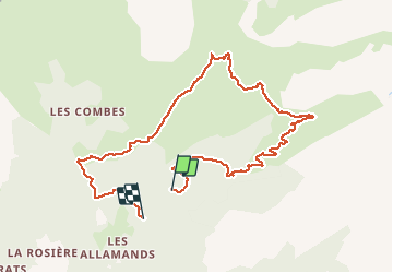
9.6 km | 12.9 km-effort
4h 1min
Yes
Trail Walking Samoëns - La Tête de Bostan - Photo
Walking
bourel.jacques

Walking

Medium
(2)
Samoëns, Auvergne-Rhône-Alpes, Upper Savoy, France
14.9 km | 32 km-effort
6h 32min
Yes
Trail Walking Verchaix - col de joux plane - Photo
Walking
labarone

Walking

Medium
Verchaix, Auvergne-Rhône-Alpes, Upper Savoy, France
10.5 km | 20 km-effort
6h 9min
Yes
Trail Walking Samoëns - La tête de Bostan - Photo
Walking
dautriche

Walking

Very difficult
Samoëns, Auvergne-Rhône-Alpes, Upper Savoy, France
15.7 km | 31 km-effort
5h 58min
Yes
Trail Walking Samoëns - SAMOENS: LES ALLAMANDS - BOSTAN (CHALETS - REFUGE - COL  - TETE) - GOLESE - Photo
Walking
djeepee74

Walking

Difficult
Samoëns, Auvergne-Rhône-Alpes, Upper Savoy, France
17.3 km | 35 km-effort
6h 52min
Yes
Trail Walking Samoëns - les chalets du Bémont et cascade du Nant d Ant - Photo
Walking
José800

Walking

Medium
Samoëns, Auvergne-Rhône-Alpes, Upper Savoy, France
6.7 km | 10.5 km-effort
2h 10min
No
Trail Walking Samoëns - SAMOENS: LAC DES CHAMBRES - Photo
Walking
djeepee74

Walking

Difficult
Samoëns, Auvergne-Rhône-Alpes, Upper Savoy, France
14.2 km | 31 km-effort
6h 11min
Yes
Trail Walking Samoëns - SAMOENS: BOSTAN - GOLESE - Photo
Walking
djeepee74

Walking

Difficult
Samoëns, Auvergne-Rhône-Alpes, Upper Savoy, France
12.8 km | 24 km-effort
4h 51min
Yes
Trail Walking Morzine - 74-Morzine-lac-mines-or-col-Coux-6.7km-515m - Photo
Walking
SyMA

Walking

Easy
Morzine, Auvergne-Rhône-Alpes, Upper Savoy, France
6.7 km | 13.5 km-effort
3h 23min
Yes


Close
My subscriptions