![](/images/other/stat-length.png)
![Trail Walking Mandailles-Saint-Julien - Les Roches Folles de Mandailles - Photo](https://media.geolcdn.com/t/1900/400/3216112a-8bb0-4dcb-a9c7-9148a43cf9be.jpg&format=pjpeg&maxdim=2)
Les Roches Folles de Mandailles
zanogueb
User
![Length](/images/other/stat-length.png)
Length
5.5 km
![Max alt](https://static1.geolcdn.com/siteimages/upload/files/1508320355ic_sort_altitude_max_24dp.png)
Max alt
1184 m
![Uphill gradient](https://static1.geolcdn.com/siteimages/upload/files/1508320355ic_sort_den_pos_24dp.png)
Uphill gradient
271 m
![Km-Effort](/images/other/stat-length.png)
Km-Effort
9.1 km
![Min alt](https://static1.geolcdn.com/siteimages/upload/files/1508320355ic_sort_altitude_min_24dp.png)
Min alt
918 m
![Downhill gradient](https://static1.geolcdn.com/siteimages/upload/files/1508320355ic_sort_den_neg_24dp.png)
Downhill gradient
276 m
![Boucle](https://static1.geolcdn.com/siteimages/upload/files/16400158638029165_repeat_loop_refresh_sync_direction_icon.png)
Boucle
Yes
Creation date :
2020-06-25 12:00:39.682
Updated on :
2020-06-28 07:48:04.603
![Walking](https://static1.geolcdn.com/sitytour/trail-icons/101.png)
2h39
Difficulty : Medium
![Scan this QR Code to open this trail in the SityTrail application](https://capi.geolives.com/qq0zvz2zws4bq2lad0pu/sitytour/trails/2450427/qr.png?size=200)
FREE GPS app for hiking
About
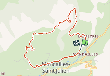
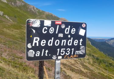
Trail Walking of 5.5 km to be discovered at Auvergne-Rhône-Alpes, Cantal, Mandailles-Saint-Julien. This trail is proposed by zanogueb.
Description
Cette boucle est issue de celle de "amiral13" qui part de Saint-Julien.
Mon départ se fait à partir du petit village de Bardugué en sens inverse.
Positioning
Country:
France
Region :
Auvergne-Rhône-Alpes
Department/Province :
Cantal
Municipality :
Mandailles-Saint-Julien
Location:
Unknown
Start:(Dec)
Start:(UTM)
472890 ; 4990782 (31T) N.
Comments
Trails nearby
![Trail Walking Mandailles-Saint-Julien - L'Elancèze - Photo](https://media.geolcdn.com/t/375/260/ext.jpg?maxdim=2&url=https%3A%2F%2Fservices.sitytrail.com%2FGeolivesWS%2FDownloadMedia.ashx%3FTrailID%3D103726%26Media%3D6387_2.jpg)
![Walking Walking](https://static1.geolcdn.com/sitytour/trail-icons/101.png)
L'Elancèze
Walking
Difficult
(1)
Mandailles-Saint-Julien,
Auvergne-Rhône-Alpes,
Cantal,
France
![](/images/other/stat-length.png)
12.8 km | 24 km-effort
5h 0min
![](https://static1.geolcdn.com/siteimages/upload/files/16400158638029165_repeat_loop_refresh_sync_direction_icon.png)
Yes
![Trail Walking Laveissière - Lioran 2023-08-18 Col de Rombière Col du Pertus A/R - Photo](https://media.geolcdn.com/t/375/260/ext.jpg?maxdim=2&url=https%3A%2F%2Fstatic1.geolcdn.com%2Fsiteimages%2Fupload%2Ffiles%2F1553511878bg_sport_marche.png)
![Walking Walking](https://static1.geolcdn.com/sitytour/trail-icons/101.png)
Lioran 2023-08-18 Col de Rombière Col du Pertus A/R
Walking
Easy
(1)
Laveissière,
Auvergne-Rhône-Alpes,
Cantal,
France
![](/images/other/stat-length.png)
12.5 km | 18.8 km-effort
4h 14min
![](https://static1.geolcdn.com/siteimages/upload/files/16400158638029165_repeat_loop_refresh_sync_direction_icon.png)
Yes
![Trail Walking Laveissière - Lioran 2023-08-09 Puy de Seycheuse - Photo](https://media.geolcdn.com/t/375/260/ext.jpg?maxdim=2&url=https%3A%2F%2Fstatic1.geolcdn.com%2Fsiteimages%2Fupload%2Ffiles%2F1553511878bg_sport_marche.png)
![Walking Walking](https://static1.geolcdn.com/sitytour/trail-icons/101.png)
Lioran 2023-08-09 Puy de Seycheuse
Walking
Very difficult
(1)
Laveissière,
Auvergne-Rhône-Alpes,
Cantal,
France
![](/images/other/stat-length.png)
13.9 km | 23 km-effort
5h 20min
![](https://static1.geolcdn.com/siteimages/upload/files/16400158638029165_repeat_loop_refresh_sync_direction_icon.png)
Yes
![Trail Hybrid bike Mandailles-Saint-Julien - Tournemire - Photo](https://media.geolcdn.com/t/375/260/e14f03b2-11fc-4b1e-a416-809203cb4d66.jpg&format=jpg&maxdim=2)
![Hybrid bike Hybrid bike](https://static1.geolcdn.com/sitytour/trail-icons/203.png)
Tournemire
Hybrid bike
Medium
Mandailles-Saint-Julien,
Auvergne-Rhône-Alpes,
Cantal,
France
![](/images/other/stat-length.png)
39 km | 50 km-effort
3h 2min
![](https://static1.geolcdn.com/siteimages/upload/files/16400158638029165_repeat_loop_refresh_sync_direction_icon.png)
No
![Trail Walking Mandailles-Saint-Julien - Mandailles Elanceze Col de Pertus - Photo](https://media.geolcdn.com/t/375/260/47acb562-9c7e-418d-99ca-e180c6cd6932.jpg&format=jpg&maxdim=2)
![Walking Walking](https://static1.geolcdn.com/sitytour/trail-icons/101.png)
Mandailles Elanceze Col de Pertus
Walking
Medium
Mandailles-Saint-Julien,
Auvergne-Rhône-Alpes,
Cantal,
France
![](/images/other/stat-length.png)
12.6 km | 23 km-effort
4h 43min
![](https://static1.geolcdn.com/siteimages/upload/files/16400158638029165_repeat_loop_refresh_sync_direction_icon.png)
Yes
![Trail Walking Le Fau - Puy violent - Photo](https://media.geolcdn.com/t/375/260/abb730dc-c4ed-4c8e-b196-15e705b50c2c.jpg&format=jpg&maxdim=2)
![Walking Walking](https://static1.geolcdn.com/sitytour/trail-icons/101.png)
Puy violent
Walking
Very difficult
Le Fau,
Auvergne-Rhône-Alpes,
Cantal,
France
![](/images/other/stat-length.png)
22 km | 37 km-effort
8h 29min
![](https://static1.geolcdn.com/siteimages/upload/files/16400158638029165_repeat_loop_refresh_sync_direction_icon.png)
Yes
![Trail Walking Laveissière - Lioran 2023-08-09 Puy de Seycheuse - Photo](https://media.geolcdn.com/t/375/260/2c958481-3205-4e5d-b01c-91f314f65f0b.jpg&format=jpg&maxdim=2)
![Walking Walking](https://static1.geolcdn.com/sitytour/trail-icons/101.png)
Lioran 2023-08-09 Puy de Seycheuse
Walking
Medium
Laveissière,
Auvergne-Rhône-Alpes,
Cantal,
France
![](/images/other/stat-length.png)
14.8 km | 25 km-effort
4h 34min
![](https://static1.geolcdn.com/siteimages/upload/files/16400158638029165_repeat_loop_refresh_sync_direction_icon.png)
Yes
![Trail Walking Le Falgoux - puy mary - Photo](https://media.geolcdn.com/t/375/260/4b95a1a6-fc74-487d-aed9-abef50730fd6.jpg&format=jpg&maxdim=2)
![Walking Walking](https://static1.geolcdn.com/sitytour/trail-icons/101.png)
puy mary
Walking
Very easy
Le Falgoux,
Auvergne-Rhône-Alpes,
Cantal,
France
![](/images/other/stat-length.png)
5.8 km | 10.9 km-effort
2h 24min
![](https://static1.geolcdn.com/siteimages/upload/files/16400158638029165_repeat_loop_refresh_sync_direction_icon.png)
Yes
![Trail Walking Le Claux - Le Peyre Arse depuis le col d'Eylac - Photo](https://media.geolcdn.com/t/375/260/21ff7450-0249-4860-9e7d-c9fc3ca72740.jpg&format=jpg&maxdim=2)
![Walking Walking](https://static1.geolcdn.com/sitytour/trail-icons/101.png)
Le Peyre Arse depuis le col d'Eylac
Walking
Medium
Le Claux,
Auvergne-Rhône-Alpes,
Cantal,
France
![](/images/other/stat-length.png)
7.6 km | 13.4 km-effort
2h 24min
![](https://static1.geolcdn.com/siteimages/upload/files/16400158638029165_repeat_loop_refresh_sync_direction_icon.png)
Yes