![](/images/other/stat-length.png)
![Trail Walking Tautavel - Tautavel chemin des bacs - Photo](https://media.geolcdn.com/t/1900/400/4347d338-087b-4ab9-a23d-b90780ad37c2.jpg&format=pjpeg&maxdim=2)
Tautavel chemin des bacs
jcmartin
User
![Length](/images/other/stat-length.png)
![Max alt](https://static1.geolcdn.com/siteimages/upload/files/1508320355ic_sort_altitude_max_24dp.png)
![Uphill gradient](https://static1.geolcdn.com/siteimages/upload/files/1508320355ic_sort_den_pos_24dp.png)
![Km-Effort](/images/other/stat-length.png)
![Min alt](https://static1.geolcdn.com/siteimages/upload/files/1508320355ic_sort_altitude_min_24dp.png)
![Downhill gradient](https://static1.geolcdn.com/siteimages/upload/files/1508320355ic_sort_den_neg_24dp.png)
![Boucle](https://static1.geolcdn.com/siteimages/upload/files/16400158638029165_repeat_loop_refresh_sync_direction_icon.png)
![Walking](https://static1.geolcdn.com/sitytour/trail-icons/101.png)
2h30
Difficulty : Easy
![Scan this QR Code to open this trail in the SityTrail application](https://capi.geolives.com/qq0zvz2zws4bq2lad0pu/sitytour/trails/2447753/qr.png?size=200)
FREE GPS app for hiking
About
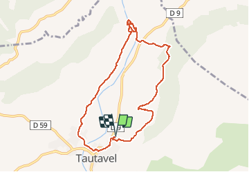
Trail Walking of 9.5 km to be discovered at Occitania, Pyrénées-Orientales, Tautavel. This trail is proposed by jcmartin.
Description
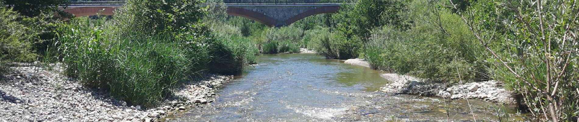
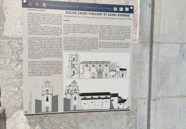
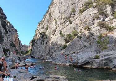
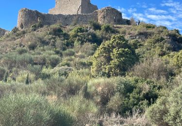
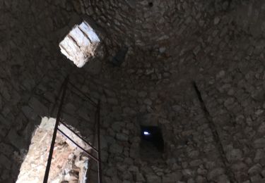
Sentier de randonnée balisé en jaune au départ de Tautavel qui longe le ruisseau du Verdouble jusqu'aux gorges de Gouleyrous qui sont surplombées par la Caune de l'Arago où ont été retrouvés des vestiges des hommes préhistoriques. La randonnée balisée fait 8,5Km et 200m de dénivelé, j'ai rajouté 1Km de plus en me promenant dans les Gorges
Positioning
Comments
Trails nearby
![Trail Walking Vingrau - Chemin des Contrebandiers Vingrau variante - Photo](https://media.geolcdn.com/t/375/260/ext.jpg?maxdim=2&url=https%3A%2F%2Fservices.sitytrail.com%2FGeolivesWS%2FDownloadMedia.ashx%3FTrailID%3D422545%26Media%3Dfix__20140613113149.jpg)
![Walking Walking](https://static1.geolcdn.com/sitytour/trail-icons/101.png)
Walking
![](/images/other/stat-length.png)
![](https://static1.geolcdn.com/siteimages/upload/files/16400158638029165_repeat_loop_refresh_sync_direction_icon.png)
![Trail Walking Vingrau - Vingrau - Photo](https://media.geolcdn.com/t/375/260/59157f3c-9cda-4a07-bd09-42a8a8a018aa.jpg&format=jpg&maxdim=2)
![Walking Walking](https://static1.geolcdn.com/sitytour/trail-icons/101.png)
Walking
![](/images/other/stat-length.png)
![](https://static1.geolcdn.com/siteimages/upload/files/16400158638029165_repeat_loop_refresh_sync_direction_icon.png)
![Trail Walking Estagel - ESTAGEL Chapelle St Laurent MARDI FAIT - Photo](https://media.geolcdn.com/t/375/260/14957312-1764-401b-980d-e06b9de6af18.jpg&format=jpg&maxdim=2)
![Walking Walking](https://static1.geolcdn.com/sitytour/trail-icons/101.png)
Walking
![](/images/other/stat-length.png)
![](https://static1.geolcdn.com/siteimages/upload/files/16400158638029165_repeat_loop_refresh_sync_direction_icon.png)
![Trail Walking Cases-de-Pène - 2023-08-01_12h04m36_SityTrail - 3754591 - cases-de-pene-x-detour-et-retour - Photo](https://media.geolcdn.com/t/375/260/883a1714-3990-4d53-92ac-a82da8ee9827.jpg&format=jpg&maxdim=2)
![Walking Walking](https://static1.geolcdn.com/sitytour/trail-icons/101.png)
Walking
![](/images/other/stat-length.png)
![](https://static1.geolcdn.com/siteimages/upload/files/16400158638029165_repeat_loop_refresh_sync_direction_icon.png)
![Trail Walking Tautavel - les gorges . tautavel par les vignes .. retour par la vallée - Photo](https://media.geolcdn.com/t/375/260/f5cf1c3a-e9df-4e15-9388-551099a87371.jpg&format=jpg&maxdim=2)
![Walking Walking](https://static1.geolcdn.com/sitytour/trail-icons/101.png)
Walking
![](/images/other/stat-length.png)
![](https://static1.geolcdn.com/siteimages/upload/files/16400158638029165_repeat_loop_refresh_sync_direction_icon.png)
![Trail Walking Paziols - paziols 19 kms - Photo](https://media.geolcdn.com/t/375/260/ddaac51d-e934-4f1b-ab1b-521ca7bf9769.jpg&format=jpg&maxdim=2)
![Walking Walking](https://static1.geolcdn.com/sitytour/trail-icons/101.png)
![Trail Walking Paziols - Paziols château d’aguilra - Photo](https://media.geolcdn.com/t/375/260/fa47ac32-1f20-4f2f-bc41-046989712c5d.jpg&format=jpg&maxdim=2)
![Walking Walking](https://static1.geolcdn.com/sitytour/trail-icons/101.png)
Walking
![](/images/other/stat-length.png)
![](https://static1.geolcdn.com/siteimages/upload/files/16400158638029165_repeat_loop_refresh_sync_direction_icon.png)
![Trail Walking Tautavel - TAUTAVEL la Tour del Far A/R - Photo](https://media.geolcdn.com/t/375/260/7315cb9e-35b2-46c7-8732-adf6f85e9975.jpg&format=jpg&maxdim=2)
![Walking Walking](https://static1.geolcdn.com/sitytour/trail-icons/101.png)
Walking
![](/images/other/stat-length.png)
![](https://static1.geolcdn.com/siteimages/upload/files/16400158638029165_repeat_loop_refresh_sync_direction_icon.png)
![Trail Walking Tautavel - Tautavel -Torre del Far - Photo](https://media.geolcdn.com/t/375/260/f1e44f1c-1dc1-496a-9f67-a9c732e79842.jpg&format=jpg&maxdim=2)
![Walking Walking](https://static1.geolcdn.com/sitytour/trail-icons/101.png)
Walking
![](/images/other/stat-length.png)
![](https://static1.geolcdn.com/siteimages/upload/files/16400158638029165_repeat_loop_refresh_sync_direction_icon.png)
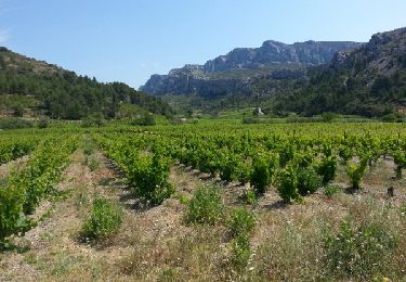
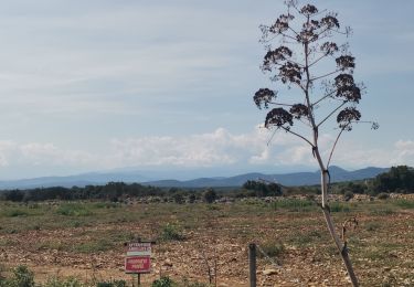
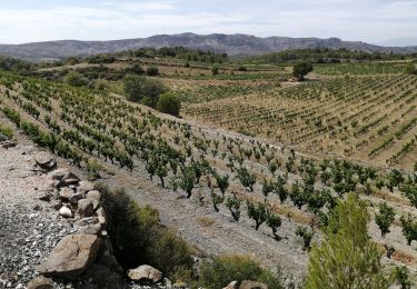
belle promenade à travers les pins et les vignes. Les gorges sont inaccessibles aux familles.
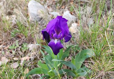
Très belle balade qui condence les plus beaux paysages de la région !