Trail Mountain bike Le Sappey - Le Salève par l'alpage de la Thuile - 18071 - UtagawaVTT.com - Photo

Le Salève par l'alpage de la Thuile - 18071 - UtagawaVTT.com

 HG74250
HG74250

User

© OpenStreetMap contributors
Length
Length
35 km
Boucle
Boucle
Yes
Creation date :
2020-06-21 18:19:19.465
Updated on :
2020-06-21 18:26:06.045

(0 Reviews)

Mountain bike
Mountain bike
3h00
Difficulty : Difficult

Scan this QR Code to open this trail in the SityTrail application

FREE GPS app for hiking

Logo SityTrail SityTrail

IGN / Geographical institutes

Download SityTrail from the App Store Download SityTrail from Google Play

Logo SityTrail SityTrail World

The world is yours!

Download SityTrail from the App Store Download SityTrail from Google Play Download SityTrail on Huawei AppGallery

About

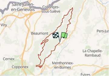
Trail Mountain bike of 35 km to be discovered at Auvergne-Rhône-Alpes, Upper Savoy, Le Sappey. This trail is proposed by HG74250.

Description

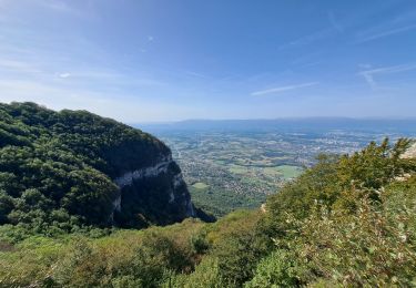
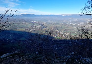
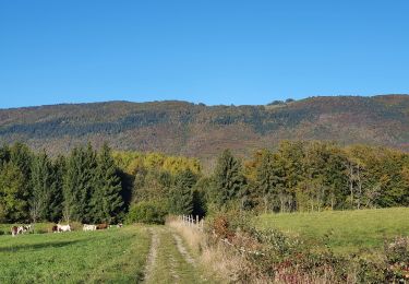
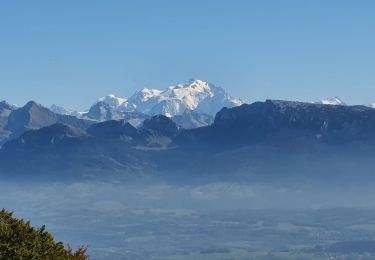
Itinéraire très varié qui permet une approche du Salève ludique et assez complète. Le départ et le retour s'effectuent par une petite route, mais ce n'est pas vraiment un problème. Échauffement pour le départ et contemplation pour le retour. Le chemin de crête, à travers les alpages, avec vue sur Genève d'un côté et le lac d'Annecy de l'autre est vraiment un régal. La descente sur l'alpage de la Thuile est conseillée par temps sec. Pas mal de racines et un secteur souvent mouillé.

Elevation profile

Positioning

Country:
France
Region :
Auvergne-Rhône-Alpes
Department/Province :
Upper Savoy
Municipality :
Le Sappey
Location:
Unknown
Start:(UTM)
280934 ; 5107820 (32T) N.

Trails nearby

Trail Walking Menthonnex-en-Bornes - Tour du plateau ds bornes - Photo
Walking
Nico222

Walking

Easy
(2)
Menthonnex-en-Bornes, Auvergne-Rhône-Alpes, Upper Savoy, France
11.6 km | 15 km-effort
3h 12min
Yes
Trail Walking La Muraz - La Croisette - Téléphérique  - Photo
Walking
Jackoyo

Walking

Easy
La Muraz, Auvergne-Rhône-Alpes, Upper Savoy, France
11.3 km | 16.4 km-effort
2h 39min
Yes
Trail Walking Collonges-sous-Salève - Le Salève en boucle,  orjobet , corraterie, belvédère, grande gorge  - Photo
Walking
Zasa

Walking

Very difficult
Collonges-sous-Salève, Auvergne-Rhône-Alpes, Upper Savoy, France
12.2 km | 23 km-effort
5h 0min
Yes
Trail Walking Collonges-sous-Salève - SALEVE - Photo
Walking
Jean-Paulchoux

Walking

Medium
Collonges-sous-Salève, Auvergne-Rhône-Alpes, Upper Savoy, France
10 km | 15.3 km-effort
2h 48min
Yes
Trail Walking Collonges-sous-Salève - GRAND SALEVE: GROTTES ET SENTIER-BALCON - Photo
Walking
djeepee74

Walking

Medium
Collonges-sous-Salève, Auvergne-Rhône-Alpes, Upper Savoy, France
9.4 km | 19.5 km-effort
4h 5min
Yes
Trail Walking Collonges-sous-Salève - Le salave .on arrive a collonge sur saleve et on part du parking du coin  - Photo
Walking
colomb24

Walking

Very difficult
Collonges-sous-Salève, Auvergne-Rhône-Alpes, Upper Savoy, France
15.8 km | 29 km-effort
53h 24min
Yes
Trail Walking Arbusigny - 23-04-2022 Arbusigny-Reignier - Photo
Walking
GUIDE
Kargil

Walking

Medium
Arbusigny, Auvergne-Rhône-Alpes, Upper Savoy, France
19.2 km | 27 km-effort
4h 6min
Yes
Trail Walking Arbusigny - Autour d'Arbusigny  - Photo
Walking
GUIDE
Kargil

Walking

Easy
Arbusigny, Auvergne-Rhône-Alpes, Upper Savoy, France
19.4 km | 26 km-effort
4h 21min
Yes
Trail Walking Collonges-sous-Salève - La Croisette - Plan du Salève - Photo
Walking
GUIDE
Kargil

Walking

Easy
Collonges-sous-Salève, Auvergne-Rhône-Alpes, Upper Savoy, France
16.6 km | 24 km-effort
4h 25min
Yes


Close
My subscriptions