![](/images/other/stat-length.png)
![Trail Electric bike Saint-Leu - Activity - Photo](https://media.geolcdn.com/t/1900/400/ext.pjpeg?maxdim=2&url=https%3A%2F%2Fstatic1.geolcdn.com%2Fsiteimages%2Fupload%2Ffiles%2F1524743154velo.jpg)
Activity
Thierry Boisselier
User
![Length](/images/other/stat-length.png)
Length
49 km
![Max alt](https://static1.geolcdn.com/siteimages/upload/files/1508320355ic_sort_altitude_max_24dp.png)
Max alt
2193 m
![Uphill gradient](https://static1.geolcdn.com/siteimages/upload/files/1508320355ic_sort_den_pos_24dp.png)
Uphill gradient
1686 m
![Km-Effort](/images/other/stat-length.png)
Km-Effort
72 km
![Min alt](https://static1.geolcdn.com/siteimages/upload/files/1508320355ic_sort_altitude_min_24dp.png)
Min alt
829 m
![Downhill gradient](https://static1.geolcdn.com/siteimages/upload/files/1508320355ic_sort_den_neg_24dp.png)
Downhill gradient
1691 m
![Boucle](https://static1.geolcdn.com/siteimages/upload/files/16400158638029165_repeat_loop_refresh_sync_direction_icon.png)
Boucle
Yes
Creation date :
2020-06-21 13:37:05.587
Updated on :
2020-06-26 08:53:18.426
![Electric bike](https://static1.geolcdn.com/sitytour/trail-icons/205.png)
--
Difficulty : Difficult
![Scan this QR Code to open this trail in the SityTrail application](https://capi.geolives.com/qq0zvz2zws4bq2lad0pu/sitytour/trails/2444812/qr.png?size=200)
FREE GPS app for hiking
About
Trail Electric bike of 49 km to be discovered at Réunion, Unknown, Saint-Leu. This trail is proposed by Thierry Boisselier.
Description
Aller par la route. Retour par route forestière très défoncée et difficile.
Tombé en panne à 1km de l'arrivée avec batterie 500 !
Positioning
Country:
France
Region :
Réunion
Department/Province :
Unknown
Municipality :
Saint-Leu
Location:
Unknown
Start:(Dec)
Start:(UTM)
324980 ; 7661122 (40K) S.
Comments
Trails nearby
![Trail Walking Saint-Leu - La Réunion - Secteur Saint Leu - Boucle Saint-Christophe par les sentiers de la Salette et Pavé. - Photo](https://media.geolcdn.com/t/375/260/ext.jpg?maxdim=2&url=https%3A%2F%2Fservices.sitytrail.com%2FGeolivesWS%2FDownloadMedia.ashx%3FTrailID%3D319177%26Media%3Dfix__20140629114557.jpg)
![Walking Walking](https://static1.geolcdn.com/sitytour/trail-icons/101.png)
La Réunion - Secteur Saint Leu - Boucle Saint-Christophe par les sentiers de ...
Walking
Medium
Saint-Leu,
Réunion,
Unknown,
France
![](/images/other/stat-length.png)
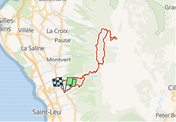
15.8 km | 28 km-effort
4h 45min
![](https://static1.geolcdn.com/siteimages/upload/files/16400158638029165_repeat_loop_refresh_sync_direction_icon.png)
Yes
![Trail Walking Les Trois-Bassins - La Grande Ravine - Les Trois-Bassins - Photo](https://media.geolcdn.com/t/375/260/ext.jpg?maxdim=2&url=https%3A%2F%2Fservices.sitytrail.com%2FGeolivesWS%2FDownloadMedia.ashx%3FTrailID%3D317916%26Media%3D17334_6.jpg)
![Walking Walking](https://static1.geolcdn.com/sitytour/trail-icons/101.png)
La Grande Ravine - Les Trois-Bassins
Walking
Difficult
Les Trois-Bassins,
Réunion,
Unknown,
France
![](/images/other/stat-length.png)
21 km | 38 km-effort
6h 30min
![](https://static1.geolcdn.com/siteimages/upload/files/16400158638029165_repeat_loop_refresh_sync_direction_icon.png)
Yes
![Trail Mountain bike Saint-Leu - 2010-11-07 - 10h44m01 - Photo](https://media.geolcdn.com/t/375/260/ext.jpg?maxdim=2&url=https%3A%2F%2Fservices.sitytrail.com%2FGeolivesWS%2FDownloadMedia.ashx%3FTrailID%3D47991%26Media%3D20101107102924.jpg)
![Mountain bike Mountain bike](https://static1.geolcdn.com/sitytour/trail-icons/202.png)
2010-11-07 - 10h44m01
Mountain bike
Very easy
Saint-Leu,
Réunion,
Unknown,
France
![](/images/other/stat-length.png)
17.4 km | 25 km-effort
Unknown
![](https://static1.geolcdn.com/siteimages/upload/files/16400158638029165_repeat_loop_refresh_sync_direction_icon.png)
No
![Trail Walking Saint-Leu - St Leu Le Cap Camélia - Photo](https://media.geolcdn.com/t/375/260/92ca7314-1976-4004-ae23-9dc4d05c4cc2.jpg&format=jpg&maxdim=2)
![Walking Walking](https://static1.geolcdn.com/sitytour/trail-icons/101.png)
St Leu Le Cap Camélia
Walking
Medium
Saint-Leu,
Réunion,
Unknown,
France
![](/images/other/stat-length.png)
14.9 km | 22 km-effort
3h 20min
![](https://static1.geolcdn.com/siteimages/upload/files/16400158638029165_repeat_loop_refresh_sync_direction_icon.png)
No
![Trail Walking Saint-Leu - St Leu - Etang-Salé par le littoral - Photo](https://media.geolcdn.com/t/375/260/a9edc3e9-6842-41b9-b29e-7ff7844c867a.jpg&format=jpg&maxdim=2)
![Walking Walking](https://static1.geolcdn.com/sitytour/trail-icons/101.png)
St Leu - Etang-Salé par le littoral
Walking
Easy
Saint-Leu,
Réunion,
Unknown,
France
![](/images/other/stat-length.png)
13.7 km | 15.5 km-effort
3h 5min
![](https://static1.geolcdn.com/siteimages/upload/files/16400158638029165_repeat_loop_refresh_sync_direction_icon.png)
No
![Trail Walking Saint-Leu - Saint Leu - Photo](https://media.geolcdn.com/t/375/260/ext.jpg?maxdim=2&url=https%3A%2F%2Fstatic1.geolcdn.com%2Fsiteimages%2Fupload%2Ffiles%2F1553511878bg_sport_marche.png)
![Walking Walking](https://static1.geolcdn.com/sitytour/trail-icons/101.png)
Saint Leu
Walking
Difficult
Saint-Leu,
Réunion,
Unknown,
France
![](/images/other/stat-length.png)
7.7 km | 13.9 km-effort
3h 10min
![](https://static1.geolcdn.com/siteimages/upload/files/16400158638029165_repeat_loop_refresh_sync_direction_icon.png)
Yes
![Trail Mountain bike Les Trois-Bassins - 2019 05 - LE TOUR DU MAIDO EN VTT PAR LES ROUTES FORESTIERES - Photo](https://media.geolcdn.com/t/375/260/ext.jpg?maxdim=2&url=https%3A%2F%2Fstatic1.geolcdn.com%2Fsiteimages%2Fupload%2Ffiles%2F1524743154velo.jpg)
![Mountain bike Mountain bike](https://static1.geolcdn.com/sitytour/trail-icons/202.png)
2019 05 - LE TOUR DU MAIDO EN VTT PAR LES ROUTES FORESTIERES
Mountain bike
Difficult
Les Trois-Bassins,
Réunion,
Unknown,
France
![](/images/other/stat-length.png)
34 km | 49 km-effort
2h 17min
![](https://static1.geolcdn.com/siteimages/upload/files/16400158638029165_repeat_loop_refresh_sync_direction_icon.png)
Yes
![Trail Walking Saint-Leu - TEST - Photo](https://media.geolcdn.com/t/375/260/ext.jpg?maxdim=2&url=https%3A%2F%2Fstatic1.geolcdn.com%2Fsiteimages%2Fupload%2Ffiles%2F1553511878bg_sport_marche.png)
![Walking Walking](https://static1.geolcdn.com/sitytour/trail-icons/101.png)
![Trail Walking Saint-Leu - Traverser Cayenne sans dévier de l'escalier central - Photo](https://media.geolcdn.com/t/375/260/ext.jpg?maxdim=2&url=https%3A%2F%2Fstatic1.geolcdn.com%2Fsiteimages%2Fupload%2Ffiles%2F1553511878bg_sport_marche.png)
![Walking Walking](https://static1.geolcdn.com/sitytour/trail-icons/101.png)
Traverser Cayenne sans dévier de l'escalier central
Walking
Medium
Saint-Leu,
Réunion,
Unknown,
France
![](/images/other/stat-length.png)
11.5 km | 23 km-effort
4h 36min
![](https://static1.geolcdn.com/siteimages/upload/files/16400158638029165_repeat_loop_refresh_sync_direction_icon.png)
Yes