Trail Walking Corconne - CORCONNE - 11.8Km - 05h00 - Dénivelé 300 m - Photo

CORCONNE - 11.8Km - 05h00 - Dénivelé 300 m

© OpenStreetMap contributors
Length
Length
11.8 km
Max alt
Max alt
339 m
Uphill gradient
Uphill gradient
321 m
Km-Effort
Km-Effort  
16.1 km
Min alt
Min alt
143 m
Downhill gradient
Downhill gradient
324 m
Boucle
Boucle
Yes
Creation date :
2014-12-10 00:00:00.0
Updated on :
2014-12-10 00:00:00.0

(0 Reviews)

Walking
Walking
3h25
Difficulty : Medium

Scan this QR Code to open this trail in the SityTrail application

FREE GPS app for hiking

Logo SityTrail SityTrail

IGN / Geographical institutes

Download SityTrail from the App Store Download SityTrail from Google Play

Logo SityTrail SityTrail World

The world is yours!

Download SityTrail from the App Store Download SityTrail from Google Play Download SityTrail on Huawei AppGallery

About

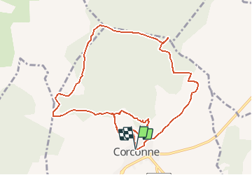
Trail Walking of 11.8 km to be discovered at Occitania, Gard, Corconne. This trail is proposed by dansmabulle.

Description

CORCONNE
11.8Km - 05h00
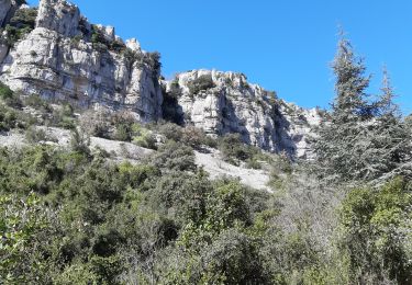
Départ randonnée : Petit village méditerranéen de Corconne (Gard) Nous monterons vers le pont du Hasard, très bel arche formé par la nature, ou nous ferons le tour de la corniche par l'Est ( chemin difficile à trouver.Nous visiterons le château et la chapelle avec une très belle vue sur le village.Nous emprunterons ensuite le chemin du Castelas, puis le chemin de Provençal jusqu'aux trois Termes, nous passerons par les Costes pour redescendre vers le village qu'il ne faut pas manquer de visiter.Bonne randonnée.

Elevation profile

Positioning

Country:
France
Region :
Occitania
Department/Province :
Gard
Municipality :
Corconne
Location:
Unknown
Start:(UTM)
575500 ; 4858188 (31T) N.

Trails nearby

Trail Walking Quissac - Quissac - Photo
Walking
JEANJOSY

Walking

Easy
(1)
Quissac, Occitania, Gard, France
11 km | 13.1 km-effort
2h 57min
Yes
Trail Walking Carnas - Carnas bois de Paris - Photo
Walking
CAMBON

Walking

Medium
(2)
Carnas, Occitania, Gard, France
12.8 km | 15.6 km-effort
4h 0min
Yes
Trail On foot Liouc - Les chênes de Coutach - Photo
On foot
GUIDE+

On foot

Easy
Liouc, Occitania, Gard, France
6.7 km | 10.6 km-effort
2h 24min
No
Trail Walking Lauret - lac de Matane / moulin de la Fous - Photo
Walking
GUIDE
nadinebondoux

Walking

Medium
Lauret, Occitania, Hérault, France
12.3 km | 17.7 km-effort
5h 5min
Yes
Trail Walking Corconne - 30 corconne - Photo
Walking
GUIDE
randodyssée

Walking

Easy
Corconne, Occitania, Gard, France
8.8 km | 12.4 km-effort
3h 45min
Yes
Trail Walking Claret - LL34 Reculée de Claret - Photo
Walking
alainandrejoly

Walking

Medium
(2)
Claret, Occitania, Hérault, France
17.1 km | 22 km-effort
5h 30min
Yes
Trail Walking Claret - LL34 Reculée de Claret-1 - Photo
Walking
alainandrejoly

Walking

Easy
(1)
Claret, Occitania, Hérault, France
12.9 km | 16.6 km-effort
3h 52min
Yes
Trail Walking Corconne - Corconne et la forêt de Coutach - Photo
Walking
grageot

Walking

Easy
(2)
Corconne, Occitania, Gard, France
18.1 km | 25 km-effort
5h 26min
Yes
Trail Walking Corconne - Corconne - Photo
Walking
Ptitjack30

Walking

Medium
(1)
Corconne, Occitania, Gard, France
11.4 km | 15.2 km-effort
3h 28min
No


Close
My subscriptions