![](/images/other/stat-length.png)
![Trail Walking Daluis - Gorges du Daluis - Photo](https://media.geolcdn.com/t/1900/400/38db2acd-ddab-438c-8fd8-215a6512b64e.jpg&format=pjpeg&maxdim=2)
Gorges du Daluis
domi06
User
![Length](/images/other/stat-length.png)
![Max alt](https://static1.geolcdn.com/siteimages/upload/files/1508320355ic_sort_altitude_max_24dp.png)
![Uphill gradient](https://static1.geolcdn.com/siteimages/upload/files/1508320355ic_sort_den_pos_24dp.png)
![Km-Effort](/images/other/stat-length.png)
![Min alt](https://static1.geolcdn.com/siteimages/upload/files/1508320355ic_sort_altitude_min_24dp.png)
![Downhill gradient](https://static1.geolcdn.com/siteimages/upload/files/1508320355ic_sort_den_neg_24dp.png)
![Boucle](https://static1.geolcdn.com/siteimages/upload/files/16400158638029165_repeat_loop_refresh_sync_direction_icon.png)
![Walking](https://static1.geolcdn.com/sitytour/trail-icons/101.png)
4h41
Difficulty : Medium
![Scan this QR Code to open this trail in the SityTrail application](https://capi.geolives.com/qq0zvz2zws4bq2lad0pu/sitytour/trails/2438607/qr.png?size=200)
FREE GPS app for hiking
About
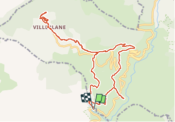
Trail Walking of 13.3 km to be discovered at Provence-Alpes-Côte d'Azur, Maritime Alps, Daluis. This trail is proposed by domi06.
Description
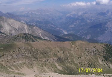
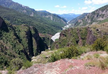
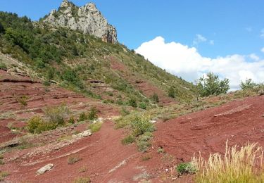
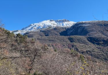
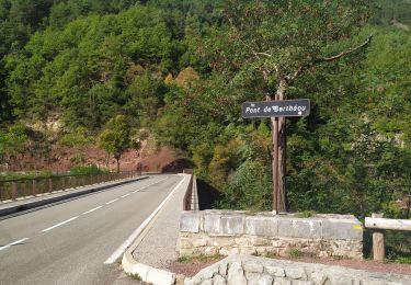
Boucle au départ du pont de Bertheou. Le sentier monte dans des zones boisées ou dénudées jusqu’à rejoindre une ancienne ferme sur le plateau de la Saussette et la petite chapelle Saint- Jacques . Rejoindre le hameau de Villeplane point culminant de ce circuit au pied du Mt St Honorat. Retour par le même sentier jusqu’à la B.69 . Prendre direction pont de Cante, descente parmi chênes et garrigues jusqu’à la balise 8. Prendre la route sur quelques centaines de mètres. A la B7, prendre le sentier en aller-retour pour atteindre le point sublime , puis une dernière descente parmi les dalles rouges pour retrouver le parking.
Positioning
Comments
Trails nearby
![Trail On foot Guillaumes - Gorges de Daluis - Photo](https://media.geolcdn.com/t/375/260/cf6f6166-06c7-4fb4-b3e6-a1ea2ecf5d7a.jpeg&format=jpg&maxdim=2)
![On foot On foot](https://static1.geolcdn.com/sitytour/trail-icons/100.png)
On foot
![](/images/other/stat-length.png)
![](https://static1.geolcdn.com/siteimages/upload/files/16400158638029165_repeat_loop_refresh_sync_direction_icon.png)
![Trail On foot Daluis - Mont Saint-Honorat - Photo](https://media.geolcdn.com/t/375/260/fc1ba9a1-932e-4ff5-9aac-8dc781637060.jpeg&format=jpg&maxdim=2)
![On foot On foot](https://static1.geolcdn.com/sitytour/trail-icons/100.png)
On foot
![](/images/other/stat-length.png)
![](https://static1.geolcdn.com/siteimages/upload/files/16400158638029165_repeat_loop_refresh_sync_direction_icon.png)
![Trail Walking Daluis - Daluis - Point Sublime - 4 km 150m - 2016 06 17 - Photo](https://media.geolcdn.com/t/375/260/ext.jpg?maxdim=2&url=https%3A%2F%2Fservices.sitytrail.com%2FGeolivesWS%2FDownloadMedia.ashx%3FTrailID%3D597790%26Media%3Dfix__20160617120004.jpg)
![Walking Walking](https://static1.geolcdn.com/sitytour/trail-icons/101.png)
Walking
![](/images/other/stat-length.png)
![](https://static1.geolcdn.com/siteimages/upload/files/16400158638029165_repeat_loop_refresh_sync_direction_icon.png)
![Trail Walking Daluis - Gorges de Daluis - Photo](https://media.geolcdn.com/t/375/260/ext.jpg?maxdim=2&url=https%3A%2F%2Fstatic1.geolcdn.com%2Fsiteimages%2Fupload%2Ffiles%2F1553511878bg_sport_marche.png)
![Walking Walking](https://static1.geolcdn.com/sitytour/trail-icons/101.png)
Walking
![](/images/other/stat-length.png)
![](https://static1.geolcdn.com/siteimages/upload/files/16400158638029165_repeat_loop_refresh_sync_direction_icon.png)
![Trail Walking Guillaumes - Gorges de Daluis - Boucle au départ du pont de Cante - Photo](https://media.geolcdn.com/t/375/260/ext.jpg?maxdim=2&url=https%3A%2F%2Fservices.sitytrail.com%2FGeolivesWS%2FDownloadMedia.ashx%3FTrailID%3D348279%26Media%3Dfix__20140925141956.jpg)
![Walking Walking](https://static1.geolcdn.com/sitytour/trail-icons/101.png)
Walking
![](/images/other/stat-length.png)
![](https://static1.geolcdn.com/siteimages/upload/files/16400158638029165_repeat_loop_refresh_sync_direction_icon.png)
![Trail Snowshoes La Croix-sur-Roudoule - Haute Mihubi - Photo](https://media.geolcdn.com/t/375/260/1d4f53a5-26a7-401e-8036-fe63dce3123b.jpg&format=jpg&maxdim=2)
![Snowshoes Snowshoes](https://static1.geolcdn.com/sitytour/trail-icons/504.png)
Snowshoes
![](/images/other/stat-length.png)
![](https://static1.geolcdn.com/siteimages/upload/files/16400158638029165_repeat_loop_refresh_sync_direction_icon.png)
![Trail Walking Daluis - Gorges de Daluis - Photo](https://media.geolcdn.com/t/375/260/617cb6d2-42fa-4d55-b1a3-65b3424d4778.jpg&format=jpg&maxdim=2)
![Walking Walking](https://static1.geolcdn.com/sitytour/trail-icons/101.png)
Walking
![](/images/other/stat-length.png)
![](https://static1.geolcdn.com/siteimages/upload/files/16400158638029165_repeat_loop_refresh_sync_direction_icon.png)
![Trail Walking Saint-Léger - Tete de Pibossan Col de Roua depuis ST Leger - Photo](https://media.geolcdn.com/t/375/260/9aee2a88-acc3-4522-8a50-f8a6868f4421.jpg&format=jpg&maxdim=2)
![Walking Walking](https://static1.geolcdn.com/sitytour/trail-icons/101.png)
Walking
![](/images/other/stat-length.png)
![](https://static1.geolcdn.com/siteimages/upload/files/16400158638029165_repeat_loop_refresh_sync_direction_icon.png)
![Trail On foot Guillaumes - Circuit d'Amen - Photo](https://media.geolcdn.com/t/375/260/faf9e9ab-a880-4a21-b636-bc915b90fa63.jpeg&format=jpg&maxdim=2)
![On foot On foot](https://static1.geolcdn.com/sitytour/trail-icons/100.png)
On foot
![](/images/other/stat-length.png)
![](https://static1.geolcdn.com/siteimages/upload/files/16400158638029165_repeat_loop_refresh_sync_direction_icon.png)