![](/images/other/stat-length.png)
![Trail Mountain bike Saint-Paul-Trois-Châteaux - Circuit Bleu n°7 Autour de Chanabasset - Photo](https://media.geolcdn.com/t/1900/400/49282f7f-d6e6-4867-8b37-f77b67fd79c1.png&format=pjpeg&maxdim=2)
Circuit Bleu n°7 Autour de Chanabasset
lespoulpes
User
![Length](/images/other/stat-length.png)
![Max alt](https://static1.geolcdn.com/siteimages/upload/files/1508320355ic_sort_altitude_max_24dp.png)
![Uphill gradient](https://static1.geolcdn.com/siteimages/upload/files/1508320355ic_sort_den_pos_24dp.png)
![Km-Effort](/images/other/stat-length.png)
![Min alt](https://static1.geolcdn.com/siteimages/upload/files/1508320355ic_sort_altitude_min_24dp.png)
![Downhill gradient](https://static1.geolcdn.com/siteimages/upload/files/1508320355ic_sort_den_neg_24dp.png)
![Boucle](https://static1.geolcdn.com/siteimages/upload/files/16400158638029165_repeat_loop_refresh_sync_direction_icon.png)
![Mountain bike](https://static1.geolcdn.com/sitytour/trail-icons/202.png)
1h33
Difficulty : Easy
![Scan this QR Code to open this trail in the SityTrail application](https://capi.geolives.com/qq0zvz2zws4bq2lad0pu/sitytour/trails/2437647/qr.png?size=200)
FREE GPS app for hiking
About
Trail Mountain bike of 20 km to be discovered at Auvergne-Rhône-Alpes, Drôme, Saint-Paul-Trois-Châteaux. This trail is proposed by lespoulpes.
Description
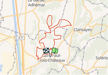
7 - FACILE | 21 km | 190 m déniv. | 1h45 Départ : Saint-Paul-Trois-Châteaux
En pays Tricastin, vous prendrez des petites routes et chemins près d’un centre équestre avant de rejoindre le bois " La Fayette " au sentier très ludique. Vous traverserez les collines de Chanabasset aux paysages et parfums méditerranéens avant d’emprunter la " voie verte " pour terminer votre ballade avec l’atypique bois de Pièjoux et rejoindre l’arrivée.
Parcours :
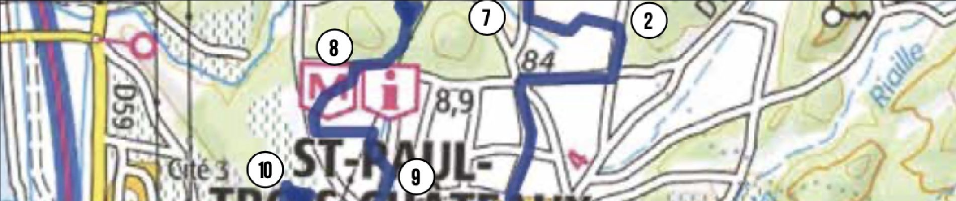
DÉPART : Place Chausy (point d’eau). Tourner à droite et suivre le balisage n°7. Emprunter des petites ruelles et atteindre un rond point. Attention voitures !
1. Prendre la 3e sortie jusqu'à un centre équestre. Plus loin, emprunter la 2e route à droite. Continuer tout droit et prendre à gauche à la prochaine bifurcation.
0,5 km
2. Prendre à gauche un chemin carrossable. À une route, tourner à droite. Attention voitures ! Prendre à nouveau à droite à la prochaine bifurcation et continuer tout droit.
2,8 km
3. Après un pont, tourner à gauche sur le chemin. Puis, plus loin, atteindre un croisement. Tourner à gauche, puis de suite à droite. Continuer tout droit sur " la petite plaine".
5,6 km
4. Au carrefour, prendre à gauche. Passer devant " la ferme des Rosières " - à découvrir ! Continuer tout droit et tourner à droite sur un pont.
6,9 km
5. Suivre à droite un chemin. Passer devant une belle bâtisse, puis s'engager à gauche sur un sentier ludique dans le bois " La Fayette ". Plus loin, tourner à gauche en suivant un chemin.
8,5 km
6. À une maison, bifurquer à gauche sur un chemin descendant jusqu'à une petite route, prendre à gauche. Attention voitures ! Repasser sur le pont pris à l'aller et continer tout droit.
9,9 km
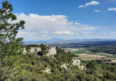
7. Prendre à droite une petite route, puis plus loin, à gauche sur un sentier en montée parfois technique (racines et pierres). Vous êtes dans les collines de " Chanabasset ".
11,7 km
8. Arriver sur une petite route, prendre en face et rejoindre la D158. Tourner à gauche, puis à 150 m bifurquer encore à gauche sur un chemin qui longe des cultures. Attention voitures !
13 km
9. Continuer à droite pour rejoindre un lotissement, le traverser en tournant à gauche. Déboucher sur la route, prendre en face et monter pour atteindre tout droit un plateau.
14,3 km
10. Au croisement, prendre à gauche et continuer au milieu des vignes. Descendre, puis à gauche traverser un lotissement en suivant bien le balisage jusqu' à une grande surface.
15,5 km
11. Emprunter " la voie verte". Soyez vigilant aux traversées de routes. Continuer toujours tout droit et atteindre " Traverse de Péjoux " (alt.83 m)
17 km
12. Tourner à gauche pour atteindre et faire le tour du bois de Piéjoux par un sentier ludique et enchanteur ! Rejoindre la voie verte et le cheminement pris à l'aller.
18,3 km
ARRIVÉE : Place Chausy (point d’eau) devant l'office de tourisme.
21 km
Positioning
Comments
Trails nearby
![Trail Walking Clansayes - SityTrail - Clansayes Le Rouvergue 6km - Photo](https://media.geolcdn.com/t/375/260/de3feb6f-5587-4e87-a580-1261cf3df48e.jpg&format=jpg&maxdim=2)
![Walking Walking](https://static1.geolcdn.com/sitytour/trail-icons/101.png)
Walking
![](/images/other/stat-length.png)
![](https://static1.geolcdn.com/siteimages/upload/files/16400158638029165_repeat_loop_refresh_sync_direction_icon.png)
![Trail Walking Saint-Restitut - St Restitut Le Barry 12km - Photo](https://media.geolcdn.com/t/375/260/52d96bcf-650b-4fd0-a59a-69f2b2d3703d.jpg&format=jpg&maxdim=2)
![Walking Walking](https://static1.geolcdn.com/sitytour/trail-icons/101.png)
Walking
![](/images/other/stat-length.png)
![](https://static1.geolcdn.com/siteimages/upload/files/16400158638029165_repeat_loop_refresh_sync_direction_icon.png)
![Trail Walking Bollène - Barry Chabrières Enclume 7,5km - Photo](https://media.geolcdn.com/t/375/260/3a4e67d1-088f-449d-b525-af6a45f2f0d7.jpg&format=jpg&maxdim=2)
![Walking Walking](https://static1.geolcdn.com/sitytour/trail-icons/101.png)
Walking
![](/images/other/stat-length.png)
![](https://static1.geolcdn.com/siteimages/upload/files/16400158638029165_repeat_loop_refresh_sync_direction_icon.png)
![Trail Walking Saint-Restitut - St Restitut Barry 14km - Photo](https://media.geolcdn.com/t/375/260/919620e4-c2f5-475b-864c-8c28884f4028.jpg&format=jpg&maxdim=2)
![Walking Walking](https://static1.geolcdn.com/sitytour/trail-icons/101.png)
Walking
![](/images/other/stat-length.png)
![](https://static1.geolcdn.com/siteimages/upload/files/16400158638029165_repeat_loop_refresh_sync_direction_icon.png)
![Trail Walking Saint-Restitut - Les carrières de Sainte Juste - Saint Restitut - Photo](https://media.geolcdn.com/t/375/260/ext.jpg?maxdim=2&url=https%3A%2F%2Fservices.sitytrail.com%2FGeolivesWS%2FDownloadMedia.ashx%3FTrailID%3D317462%26Media%3D16693_6.jpg)
![Walking Walking](https://static1.geolcdn.com/sitytour/trail-icons/101.png)
Walking
![](/images/other/stat-length.png)
![](https://static1.geolcdn.com/siteimages/upload/files/16400158638029165_repeat_loop_refresh_sync_direction_icon.png)
![Trail Walking Suze-la-Rousse - soleirieu - Photo](https://media.geolcdn.com/t/375/260/ext.jpg?maxdim=2&url=https%3A%2F%2Fstatic1.geolcdn.com%2Fsiteimages%2Fupload%2Ffiles%2F1553511878bg_sport_marche.png)
![Walking Walking](https://static1.geolcdn.com/sitytour/trail-icons/101.png)
Walking
![](/images/other/stat-length.png)
![](https://static1.geolcdn.com/siteimages/upload/files/16400158638029165_repeat_loop_refresh_sync_direction_icon.png)
![Trail Walking Clansayes - 2022-06-24_19h24m07_Clansayes Le Rouvergue 11km.gpx.xml - Photo](https://media.geolcdn.com/t/375/260/89c952dc-9c57-4311-93c9-63263f0349ef.jpg&format=jpg&maxdim=2)
![Walking Walking](https://static1.geolcdn.com/sitytour/trail-icons/101.png)
Walking
![](/images/other/stat-length.png)
![](https://static1.geolcdn.com/siteimages/upload/files/16400158638029165_repeat_loop_refresh_sync_direction_icon.png)
![Trail Walking Clansayes - 2022-05-26_08h43m46_Clansayes Le Rouvergue 8km.gpx.xml - Photo](https://media.geolcdn.com/t/375/260/00183d4b-7799-462e-b9b9-5e3d9f7cb776.jpg&format=jpg&maxdim=2)
![Walking Walking](https://static1.geolcdn.com/sitytour/trail-icons/101.png)
Walking
![](/images/other/stat-length.png)
![](https://static1.geolcdn.com/siteimages/upload/files/16400158638029165_repeat_loop_refresh_sync_direction_icon.png)
![Trail Walking Clansayes - SityTrail - 2656269 - chantemerle-clansayes-15km - Photo](https://media.geolcdn.com/t/375/260/10944c4f-f60a-41d6-ab1f-e2a3431a6612.jpg&format=jpg&maxdim=2)
![Walking Walking](https://static1.geolcdn.com/sitytour/trail-icons/101.png)
Walking
![](/images/other/stat-length.png)
![](https://static1.geolcdn.com/siteimages/upload/files/16400158638029165_repeat_loop_refresh_sync_direction_icon.png)