![](/images/other/stat-length.png)
![Trail Mountain bike Braine-l’Alleud - VTT 40 KM au départ de Braine-l'alleud - Photo](https://media.geolcdn.com/t/1900/400/ext.pjpeg?maxdim=2&url=https%3A%2F%2Fstatic1.geolcdn.com%2Fsiteimages%2Fupload%2Ffiles%2F1524743154velo.jpg)
VTT 40 KM au départ de Braine-l'alleud
DidierDHane
User
![Length](/images/other/stat-length.png)
Length
35 km
![Max alt](https://static1.geolcdn.com/siteimages/upload/files/1508320355ic_sort_altitude_max_24dp.png)
Max alt
157 m
![Uphill gradient](https://static1.geolcdn.com/siteimages/upload/files/1508320355ic_sort_den_pos_24dp.png)
Uphill gradient
539 m
![Km-Effort](/images/other/stat-length.png)
Km-Effort
43 km
![Min alt](https://static1.geolcdn.com/siteimages/upload/files/1508320355ic_sort_altitude_min_24dp.png)
Min alt
46 m
![Downhill gradient](https://static1.geolcdn.com/siteimages/upload/files/1508320355ic_sort_den_neg_24dp.png)
Downhill gradient
540 m
![Boucle](https://static1.geolcdn.com/siteimages/upload/files/16400158638029165_repeat_loop_refresh_sync_direction_icon.png)
Boucle
Yes
Creation date :
2020-06-14 08:57:03.956
Updated on :
2020-06-14 12:16:16.735
![Mountain bike](https://static1.geolcdn.com/sitytour/trail-icons/202.png)
2h06
Difficulty : Very easy
![Scan this QR Code to open this trail in the SityTrail application](https://capi.geolives.com/qq0zvz2zws4bq2lad0pu/sitytour/trails/2435750/qr.png?size=200)
FREE GPS app for hiking
About
Trail Mountain bike of 35 km to be discovered at Wallonia, Walloon Brabant, Braine-l’Alleud. This trail is proposed by DidierDHane.
Description
40 km au départ de Braine-l'alleud vers Ittre , arrêt chez Thuur au bois de Lembeek 👍🏽retour par le bois de Halle vers l'Ermite 👍🏽🖕
Positioning
Country:
Belgium
Region :
Wallonia
Department/Province :
Walloon Brabant
Municipality :
Braine-l’Alleud
Location:
Braine-l’Alleud
Start:(Dec)
Start:(UTM)
597223 ; 5614433 (31U) N.
Comments
Trails nearby
![Trail Walking Braine-l’Alleud - RB-Bw-13_Braine-l'Alleud - Photo](https://media.geolcdn.com/t/375/260/ext.jpg?maxdim=2&url=https%3A%2F%2Fservices.sitytrail.com%2FGeolivesWS%2FDownloadMedia.ashx%3FTrailID%3D179588%26Media%3D9ffdd7b7-2039-4356-b235-ee33d9a18bd7.jpg)
![Walking Walking](https://static1.geolcdn.com/sitytour/trail-icons/101.png)
RB-Bw-13_Braine-l'Alleud
Walking
Very difficult
(5)
Braine-l’Alleud,
Wallonia,
Walloon Brabant,
Belgium
![](/images/other/stat-length.png)
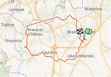
21 km | 27 km-effort
6h 2min
![](https://static1.geolcdn.com/siteimages/upload/files/16400158638029165_repeat_loop_refresh_sync_direction_icon.png)
Yes
![Trail Walking Braine-l’Alleud - RB-Bw-13 - Raccourci - Le Hain entre deux Braines - Photo](https://media.geolcdn.com/t/375/260/ext.jpg?maxdim=2&url=https%3A%2F%2Fservices.sitytrail.com%2FGeolivesWS%2FDownloadMedia.ashx%3FTrailID%3D220430%26Media%3D9ffdd7b7-2039-4356-b235-ee33d9a18bd7.jpg)
![Walking Walking](https://static1.geolcdn.com/sitytour/trail-icons/101.png)
RB-Bw-13 - Raccourci - Le Hain entre deux Braines
Walking
Difficult
(6)
Braine-l’Alleud,
Wallonia,
Walloon Brabant,
Belgium
![](/images/other/stat-length.png)
14.8 km | 18.8 km-effort
4h 16min
![](https://static1.geolcdn.com/siteimages/upload/files/16400158638029165_repeat_loop_refresh_sync_direction_icon.png)
Yes
![Trail Mountain bike Braine-l’Alleud - O2bikers_58_Waterloo - Photo](https://media.geolcdn.com/t/375/260/ext.jpg?maxdim=2&url=https%3A%2F%2Fstatic1.geolcdn.com%2Fsiteimages%2Fupload%2Ffiles%2F1524743154velo.jpg)
![Mountain bike Mountain bike](https://static1.geolcdn.com/sitytour/trail-icons/202.png)
O2bikers_58_Waterloo
Mountain bike
Very easy
(5)
Braine-l’Alleud,
Wallonia,
Walloon Brabant,
Belgium
![](/images/other/stat-length.png)
30 km | 37 km-effort
4h 11min
![](https://static1.geolcdn.com/siteimages/upload/files/16400158638029165_repeat_loop_refresh_sync_direction_icon.png)
Yes
![Mountain bike Mountain bike](https://static1.geolcdn.com/sitytour/trail-icons/202.png)
VTT a plancenoit
Mountain bike
Difficult
(1)
Lasne,
Wallonia,
Walloon Brabant,
Belgium
![](/images/other/stat-length.png)
28 km | 34 km-effort
2h 20min
![](https://static1.geolcdn.com/siteimages/upload/files/16400158638029165_repeat_loop_refresh_sync_direction_icon.png)
Yes
![Trail Mountain bike Waterloo - De Waterloo à la forêt de Soignes - Photo](https://media.geolcdn.com/t/375/260/ext.jpg?maxdim=2&url=https%3A%2F%2Fservices.sitytrail.com%2FGeolivesWS%2FDownloadMedia.ashx%3FTrailID%3D688453%26Media%3D31ac41f9-68d5-4a4a-9a8e-a882e9787769.JPG)
![Mountain bike Mountain bike](https://static1.geolcdn.com/sitytour/trail-icons/202.png)
De Waterloo à la forêt de Soignes
Mountain bike
Medium
(1)
Waterloo,
Wallonia,
Walloon Brabant,
Belgium
![](/images/other/stat-length.png)
39 km | 47 km-effort
3h 1min
![](https://static1.geolcdn.com/siteimages/upload/files/16400158638029165_repeat_loop_refresh_sync_direction_icon.png)
Yes
![Walking Walking](https://static1.geolcdn.com/sitytour/trail-icons/101.png)
#240315 - Ohain Golf de Waterloo Marache
Walking
Medium
(1)
Lasne,
Wallonia,
Walloon Brabant,
Belgium
![](/images/other/stat-length.png)
6.3 km | 7.4 km-effort
1h 41min
![](https://static1.geolcdn.com/siteimages/upload/files/16400158638029165_repeat_loop_refresh_sync_direction_icon.png)
Yes
![Trail Walking Braine-l’Alleud - #221003 - Braine-l'Alleud, Timpe et Tard et Bois du Foriest, Parc et Lac du Paradis*** - Photo](https://media.geolcdn.com/t/375/260/7ca9587d-0fe0-4627-96a6-2d18fe7f584a.jpg&format=jpg&maxdim=2)
![Walking Walking](https://static1.geolcdn.com/sitytour/trail-icons/101.png)
#221003 - Braine-l'Alleud, Timpe et Tard et Bois du Foriest, Parc et Lac du P...
Walking
Medium
(1)
Braine-l’Alleud,
Wallonia,
Walloon Brabant,
Belgium
![](/images/other/stat-length.png)
8.1 km | 9.8 km-effort
2h 13min
![](https://static1.geolcdn.com/siteimages/upload/files/16400158638029165_repeat_loop_refresh_sync_direction_icon.png)
Yes
![Walking Walking](https://static1.geolcdn.com/sitytour/trail-icons/101.png)
RB 11 Plancenoit - Lasnes
Walking
Easy
(1)
Lasne,
Wallonia,
Walloon Brabant,
Belgium
![](/images/other/stat-length.png)
12.8 km | 15.6 km-effort
2h 42min
![](https://static1.geolcdn.com/siteimages/upload/files/16400158638029165_repeat_loop_refresh_sync_direction_icon.png)
Yes
![Trail Cycle Waterloo - Du Domaine Solvay (Château de La Hulpe + Fondation Folon) à la Butte du Lion - Photo](https://media.geolcdn.com/t/375/260/6e2b14e5-7f01-4b82-86ec-767250ffcdcd.jpg&format=jpg&maxdim=2)
![Cycle Cycle](https://static1.geolcdn.com/sitytour/trail-icons/200.png)
Du Domaine Solvay (Château de La Hulpe + Fondation Folon) à la Butte du Lion
Cycle
Very easy
(2)
Waterloo,
Wallonia,
Walloon Brabant,
Belgium
![](/images/other/stat-length.png)
28 km | 32 km-effort
Unknown
![](https://static1.geolcdn.com/siteimages/upload/files/16400158638029165_repeat_loop_refresh_sync_direction_icon.png)
No