Trail Other activity Comines-Warneton - ploegsteert - Photo
 1418
1418

User

© OpenStreetMap contributors
Length
Length
10.8 km
Max alt
Max alt
38 m
Uphill gradient
Uphill gradient
67 m
Km-Effort
Km-Effort  
11.6 km
Min alt
Min alt
14 m
Downhill gradient
Downhill gradient
67 m
Boucle
Boucle
Yes
Creation date :
2014-12-10 00:00:00.0
Updated on :
2014-12-10 00:00:00.0

(0 Reviews)

Other activity
Other activity
--
Difficulty : Unknown

Scan this QR Code to open this trail in the SityTrail application

FREE GPS app for hiking

Logo SityTrail SityTrail

IGN / Geographical institutes

Download SityTrail from the App Store Download SityTrail from Google Play

Logo SityTrail SityTrail World

The world is yours!

Download SityTrail from the App Store Download SityTrail from Google Play Download SityTrail on Huawei AppGallery

About

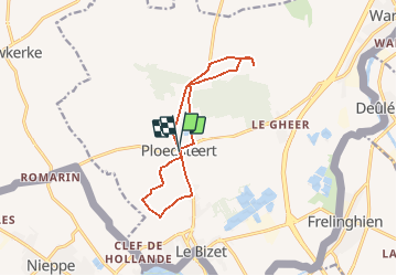
Trail Other activity of 10.8 km to be discovered at Wallonia, Hainaut, Comines-Warneton. This trail is proposed by 1418.

Elevation profile

Positioning

Country:
Belgium
Region :
Wallonia
Department/Province :
Hainaut
Municipality :
Comines-Warneton
Location:
Ploegsteert
Start:(UTM)
491549 ; 5619431 (31U) N.

Trails nearby

Trail On foot Heuvelland - Geuzen wandelroute - Photo
On foot
GUIDE+

On foot

Easy
Heuvelland, Flanders, West Flanders, Belgium
9.7 km | 11.4 km-effort
2h 35min
Yes
Trail Walking Frelinghien - Frelinghien 10,9 km - Photo
Walking
GUIDE
rvapeldo

Walking

Medium
Frelinghien, Hauts-de-France, Nord, France
10.9 km | 11.7 km-effort
2h 56min
Yes
Trail Walking Armentières - Armantiere 11 km - Photo
Walking
GUIDE
rvapeldo

Walking

Easy
Armentières, Hauts-de-France, Nord, France
10.9 km | 11.6 km-effort
3h 41min
Yes
Trail Walking Frelinghien - Frelinghien Deule 13 km - Photo
Walking
GUIDE
rvapeldo

Walking

Easy
Frelinghien, Hauts-de-France, Nord, France
13.2 km | 14 km-effort
4h 3min
Yes
Trail Walking Heuvelland - Nieuwekerke Bailleul 17,5 km - Photo
Walking
GUIDE
rvapeldo

Walking

Medium
Heuvelland, Flanders, West Flanders, Belgium
18.7 km | 21 km-effort
4h 53min
Yes
Trail Walking Armentières - Au fil de l''eau - Armentières - Photo
Walking
tracegps

Walking

Medium
Armentières, Hauts-de-France, Nord, France
8.5 km | 9.1 km-effort
2h 10min
Yes
Trail Mountain bike Armentières - Vers la confluence de la Lys et de la Deûle - Armentières - Photo
Mountain bike
tracegps

Mountain bike

Medium
Armentières, Hauts-de-France, Nord, France
23 km | 25 km-effort
2h 30min
Yes
Trail Walking Armentières - Vers la confluence de la Lys et de la Deûle - Armentières - Photo
Walking
tracegps

Walking

Very difficult
Armentières, Hauts-de-France, Nord, France
23 km | 25 km-effort
6h 0min
Yes
Trail Mountain bike Armentières - La Lys du plat pays entre Serpentine et Warnave - Armentières - Photo
Mountain bike
tracegps

Mountain bike

Medium
Armentières, Hauts-de-France, Nord, France
37 km | 40 km-effort
3h 0min
Yes


Close
My subscriptions