Trail Walking Hénon - Dans le bois des pins. - Photo

Dans le bois des pins.

 Alphe
Alphe

User

© OpenStreetMap contributors
Length
Length
9.5 km
Max alt
Max alt
217 m
Uphill gradient
Uphill gradient
190 m
Km-Effort
Km-Effort  
12 km
Min alt
Min alt
105 m
Downhill gradient
Downhill gradient
184 m
Boucle
Boucle
Yes
Creation date :
2020-06-09 07:10:11.195
Updated on :
2020-06-09 10:51:32.601

(0 Reviews)

Walking
Walking
2h13
Difficulty : Easy

Scan this QR Code to open this trail in the SityTrail application

FREE GPS app for hiking

Logo SityTrail SityTrail

IGN / Geographical institutes

Download SityTrail from the App Store Download SityTrail from Google Play

Logo SityTrail SityTrail World

The world is yours!

Download SityTrail from the App Store Download SityTrail from Google Play Download SityTrail on Huawei AppGallery

About

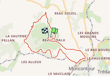
Trail Walking of 9.5 km to be discovered at Brittany, Côtes-d'Armor, Hénon. This trail is proposed by Alphe.

Description

Départ au village de Beaucadolu, et prendre en descendant le village un sentier sur la gauche qui conduit dans le bois. Suivre la trace enregistrèe sur un circuit en sous-bois très diversifié qui conduit vers une vue sur les remparts de Moncontour. Arrivé sur la route, après l'entrée du château des Granges prendre la première route a gauche qui conduit  au point de départ.

Elevation profile

Photos

Positioning

Country:
France
Region :
Brittany
Department/Province :
Côtes-d'Armor
Municipality :
Hénon
Location:
Unknown
Start:(UTM)
525815 ; 5357605 (30U) N.

Trails nearby

Trail Walking Trédaniel - Tredaniel - Montcontour - Photo
Walking
nolsim

Walking

Medium
(1)
Trédaniel, Brittany, Côtes-d'Armor, France
20 km | 26 km-effort
5h 12min
Yes
Trail Walking Trédaniel - moncontour - Photo
Walking
ballay

Walking

Easy
Trédaniel, Brittany, Côtes-d'Armor, France
20 km | 26 km-effort
6h 11min
No
Trail Running Plémy - La Crapahute, Menestrail - Photo
Running
philoustetou

Running

Medium
Plémy, Brittany, Côtes-d'Armor, France
11.9 km | 14.9 km-effort
1h 10min
Yes
Trail Walking Trédaniel - Col du mont Bel-Air 336m - Photo
Walking
elieb

Walking

Medium
Trédaniel, Brittany, Côtes-d'Armor, France
9.1 km | 12.4 km-effort
2h 14min
No


Close
My subscriptions