![](/images/other/stat-length.png)
![Trail Walking Saint-Donat-sur-l'Herbasse - Saint Donat - Photo](https://media.geolcdn.com/t/1900/400/ext.pjpeg?maxdim=2&url=https%3A%2F%2Fstatic1.geolcdn.com%2Fsiteimages%2Fupload%2Ffiles%2F1553511878bg_sport_marche.png)
Saint Donat
meillon
User
![Length](/images/other/stat-length.png)
Length
10.4 km
![Max alt](https://static1.geolcdn.com/siteimages/upload/files/1508320355ic_sort_altitude_max_24dp.png)
Max alt
361 m
![Uphill gradient](https://static1.geolcdn.com/siteimages/upload/files/1508320355ic_sort_den_pos_24dp.png)
Uphill gradient
270 m
![Km-Effort](/images/other/stat-length.png)
Km-Effort
14 km
![Min alt](https://static1.geolcdn.com/siteimages/upload/files/1508320355ic_sort_altitude_min_24dp.png)
Min alt
205 m
![Downhill gradient](https://static1.geolcdn.com/siteimages/upload/files/1508320355ic_sort_den_neg_24dp.png)
Downhill gradient
269 m
![Boucle](https://static1.geolcdn.com/siteimages/upload/files/16400158638029165_repeat_loop_refresh_sync_direction_icon.png)
Boucle
Yes
Creation date :
2020-06-05 07:55:34.418
Updated on :
2020-06-05 12:35:09.385
![Walking](https://static1.geolcdn.com/sitytour/trail-icons/101.png)
4h38
Difficulty : Very easy
![Scan this QR Code to open this trail in the SityTrail application](https://capi.geolives.com/qq0zvz2zws4bq2lad0pu/sitytour/trails/2425233/qr.png?size=200)
FREE GPS app for hiking
About
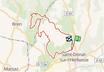
Trail Walking of 10.4 km to be discovered at Auvergne-Rhône-Alpes, Drôme, Saint-Donat-sur-l'Herbasse. This trail is proposed by meillon.
Description
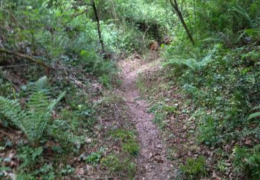
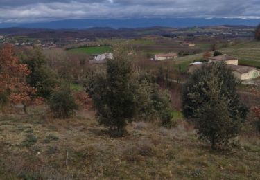
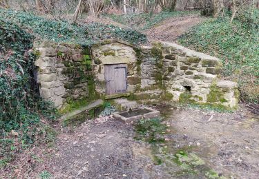
En partant du cimetière de Saint Donat à travers collines. Passage près de la croix bleue, but de rogations au dix-neuvième siècle. merci à celui qui a créé le parcours. Quelques ronces à franchir...
Positioning
Country:
France
Region :
Auvergne-Rhône-Alpes
Department/Province :
Drôme
Municipality :
Saint-Donat-sur-l'Herbasse
Location:
Unknown
Start:(Dec)
Start:(UTM)
655862 ; 4998890 (31T) N.
Comments
Trails nearby
![Trail Walking Bren - 26 bren 29 04 2021 - Photo](https://media.geolcdn.com/t/375/260/0cd863fd-960e-47f7-9bdd-faf5e995b7a6.jpg&format=jpg&maxdim=2)
![Walking Walking](https://static1.geolcdn.com/sitytour/trail-icons/101.png)
26 bren 29 04 2021
Walking
Easy
Bren,
Auvergne-Rhône-Alpes,
Drôme,
France
![](/images/other/stat-length.png)
17.4 km | 24 km-effort
6h 1min
![](https://static1.geolcdn.com/siteimages/upload/files/16400158638029165_repeat_loop_refresh_sync_direction_icon.png)
No
![Trail sport Chavannes - Étang du Mouchet , Chavannes, Chantemerle les Blés - Photo](https://media.geolcdn.com/t/375/260/717d30e8-d521-4dfb-b0ab-2496eaa170d4.jpg&format=jpg&maxdim=2)
Étang du Mouchet , Chavannes, Chantemerle les Blés
sport
Very easy
Chavannes,
Auvergne-Rhône-Alpes,
Drôme,
France
![](/images/other/stat-length.png)
12.4 km | 15.7 km-effort
Unknown
![](https://static1.geolcdn.com/siteimages/upload/files/16400158638029165_repeat_loop_refresh_sync_direction_icon.png)
Yes
![Trail Walking Saint-Bardoux - 26 st bardoux - Photo](https://media.geolcdn.com/t/375/260/c6008a2f-fee4-4474-b4e7-42a6de67bb8a.jpg&format=jpg&maxdim=2)
![Walking Walking](https://static1.geolcdn.com/sitytour/trail-icons/101.png)
26 st bardoux
Walking
Easy
Saint-Bardoux,
Auvergne-Rhône-Alpes,
Drôme,
France
![](/images/other/stat-length.png)
21 km | 28 km-effort
6h 2min
![](https://static1.geolcdn.com/siteimages/upload/files/16400158638029165_repeat_loop_refresh_sync_direction_icon.png)
Yes
![Trail Walking Saint-Donat-sur-l'Herbasse - 26 st donat sizay 18 04 2021 - Photo](https://media.geolcdn.com/t/375/260/fa2afb1e-c323-4ed6-b995-4570b7209fea.jpg&format=jpg&maxdim=2)
![Walking Walking](https://static1.geolcdn.com/sitytour/trail-icons/101.png)
26 st donat sizay 18 04 2021
Walking
Easy
Saint-Donat-sur-l'Herbasse,
Auvergne-Rhône-Alpes,
Drôme,
France
![](/images/other/stat-length.png)
19.9 km | 26 km-effort
6h 20min
![](https://static1.geolcdn.com/siteimages/upload/files/16400158638029165_repeat_loop_refresh_sync_direction_icon.png)
No
![Trail Walking Saint-Donat-sur-l'Herbasse - lac de champos bois de sizay - Photo](https://media.geolcdn.com/t/375/260/ext.jpg?maxdim=2&url=https%3A%2F%2Fstatic1.geolcdn.com%2Fsiteimages%2Fupload%2Ffiles%2F1553511878bg_sport_marche.png)
![Walking Walking](https://static1.geolcdn.com/sitytour/trail-icons/101.png)
lac de champos bois de sizay
Walking
Very easy
(1)
Saint-Donat-sur-l'Herbasse,
Auvergne-Rhône-Alpes,
Drôme,
France
![](/images/other/stat-length.png)
11.2 km | 14.6 km-effort
3h 1min
![](https://static1.geolcdn.com/siteimages/upload/files/16400158638029165_repeat_loop_refresh_sync_direction_icon.png)
Yes
![Trail Walking Saint-Donat-sur-l'Herbasse - pendillon covid - Photo](https://media.geolcdn.com/t/375/260/ext.jpg?maxdim=2&url=https%3A%2F%2Fstatic1.geolcdn.com%2Fsiteimages%2Fupload%2Ffiles%2F1553511878bg_sport_marche.png)
![Walking Walking](https://static1.geolcdn.com/sitytour/trail-icons/101.png)
pendillon covid
Walking
Very easy
(1)
Saint-Donat-sur-l'Herbasse,
Auvergne-Rhône-Alpes,
Drôme,
France
![](/images/other/stat-length.png)
8.8 km | 12.1 km-effort
1h 32min
![](https://static1.geolcdn.com/siteimages/upload/files/16400158638029165_repeat_loop_refresh_sync_direction_icon.png)
Yes
![Trail Walking Saint-Donat-sur-l'Herbasse - le bois de Sizay - Photo](https://media.geolcdn.com/t/375/260/ext.jpg?maxdim=2&url=https%3A%2F%2Fservices.sitytrail.com%2FGeolivesWS%2FDownloadMedia.ashx%3FTrailID%3D224105%26Media%3Dfix__20130928165223.jpg)
![Walking Walking](https://static1.geolcdn.com/sitytour/trail-icons/101.png)
le bois de Sizay
Walking
Very easy
Saint-Donat-sur-l'Herbasse,
Auvergne-Rhône-Alpes,
Drôme,
France
![](/images/other/stat-length.png)
6.1 km | 8.6 km-effort
1h 52min
![](https://static1.geolcdn.com/siteimages/upload/files/16400158638029165_repeat_loop_refresh_sync_direction_icon.png)
Yes
![Trail Walking Saint-Donat-sur-l'Herbasse - 26 st donar pas a pas - Photo](https://media.geolcdn.com/t/375/260/445b6fdb-5ea9-41cd-9dc1-78408223b891.jpg&format=jpg&maxdim=2)
![Walking Walking](https://static1.geolcdn.com/sitytour/trail-icons/101.png)
26 st donar pas a pas
Walking
Very easy
Saint-Donat-sur-l'Herbasse,
Auvergne-Rhône-Alpes,
Drôme,
France
![](/images/other/stat-length.png)
10.6 km | 15.7 km-effort
3h 24min
![](https://static1.geolcdn.com/siteimages/upload/files/16400158638029165_repeat_loop_refresh_sync_direction_icon.png)
No
![Trail Walking Saint-Donat-sur-l'Herbasse - champo bois de sizey rb azur - Photo](https://media.geolcdn.com/t/375/260/b9dfb9cd-71fa-4516-9af8-3166ad957935.jpg&format=jpg&maxdim=2)
![Walking Walking](https://static1.geolcdn.com/sitytour/trail-icons/101.png)
champo bois de sizey rb azur
Walking
Medium
Saint-Donat-sur-l'Herbasse,
Auvergne-Rhône-Alpes,
Drôme,
France
![](/images/other/stat-length.png)
14.8 km | 18.3 km-effort
4h 36min
![](https://static1.geolcdn.com/siteimages/upload/files/16400158638029165_repeat_loop_refresh_sync_direction_icon.png)
Yes