Trail On foot Thollon-les-Mémises - Le Grand Roc et retour - Photo
 otbernex
otbernex

User

© OpenStreetMap contributors
Length
Length
4 km
Max alt
Max alt
1060 m
Uphill gradient
Uphill gradient
104 m
Km-Effort
Km-Effort  
5.4 km
Min alt
Min alt
1013 m
Downhill gradient
Downhill gradient
104 m
Boucle
Boucle
Yes
Creation date :
2020-06-05 08:06:45.691
Updated on :
2020-06-05 08:08:41.462

(0 Reviews)

On foot
On foot
1h10
Difficulty : Very easy

Scan this QR Code to open this trail in the SityTrail application

FREE GPS app for hiking

Logo SityTrail SityTrail

IGN / Geographical institutes

Download SityTrail from the App Store Download SityTrail from Google Play

Logo SityTrail SityTrail World

The world is yours!

Download SityTrail from the App Store Download SityTrail from Google Play Download SityTrail on Huawei AppGallery

About

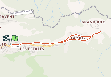
Trail On foot of 4 km to be discovered at Auvergne-Rhône-Alpes, Upper Savoy, Thollon-les-Mémises. This trail is proposed by otbernex.

Description

Depuis Thollon Tourisme, suivre les
indications pour Lajoux en longeant la
route goudronnée. Avant le restaurant
l’Outa, prendre à gauche le chemin
piéton puis vous passerez devant la
grotte de Notre Dame des Auguets.
Prendre sur la droite le chemin de
Croix. Vous arrivez à l’entrée du
hameau de Lajoux et suivre la route
goudronnée Le Grand Roc. Dans le
virage, superbe belvédère sur le haut
lac. Vue sur l’embouchure du Rhône,
les Alpes Vaudoises et Valaisannes.
Vous avez en face de vous le coeur des
Alpes Suisses. Retour par le même chemin.

Elevation profile

Positioning

Country:
France
Region :
Auvergne-Rhône-Alpes
Department/Province :
Upper Savoy
Municipality :
Thollon-les-Mémises
Location:
Unknown
Start:(UTM)
324159 ; 5139970 (32T) N.

Trails nearby

Trail Walking Bernex - Dent d'Oche - coucher de soleil  - Photo
Walking
dalla.anthony

Walking

Medium
(4)
Bernex, Auvergne-Rhône-Alpes, Upper Savoy, France
9.2 km | 22 km-effort
3h 13min
Yes
Trail Walking Bernex - Pic des mémises . colombier par Creusaz  - Photo
Walking
GUIDE
nadd73

Walking

Medium
Bernex, Auvergne-Rhône-Alpes, Upper Savoy, France
8 km | 15.1 km-effort
4h 7min
No
Trail Walking Bernex - Rando Bernex - Photo
Walking
Fab-Oz

Walking

Difficult
Bernex, Auvergne-Rhône-Alpes, Upper Savoy, France
15.9 km | 30 km-effort
5h 25min
Yes
Trail Walking Bernex - DENT D'OCHE ET LAC D'ARBON - Photo
Walking
djeepee74

Walking

Very difficult
Bernex, Auvergne-Rhône-Alpes, Upper Savoy, France
10.5 km | 26 km-effort
5h 51min
Yes
Trail Walking Bernex - Boucle depuis Pre Richard.. - Photo
Walking
tyax93

Walking

Medium
Bernex, Auvergne-Rhône-Alpes, Upper Savoy, France
10 km | 19.6 km-effort
4h 46min
Yes
Trail Walking Thollon-les-Mémises - Pic des Mémises-Col de Pertuis-Le Hameau de L’Ain retour Parking - Photo
Walking
Schaff

Walking

Difficult
Thollon-les-Mémises, Auvergne-Rhône-Alpes, Upper Savoy, France
11.4 km | 16.2 km-effort
2h 32min
No
Trail Walking Bernex - Tour du Mont César - Photo
Walking
perenhout

Walking

Medium
Bernex, Auvergne-Rhône-Alpes, Upper Savoy, France
4.4 km | 9.4 km-effort
1h 44min
Yes
Trail Nordic walking Bernex - DENT D OCHE PAR PIC BOLLE  - Photo
Nordic walking
leclaude74

Nordic walking

Difficult
Bernex, Auvergne-Rhône-Alpes, Upper Savoy, France
16 km | 34 km-effort
5h 37min
Yes
Trail Walking Saint-Paul-en-Chablais - lac noir grand tour - Photo
Walking
DMathieu10

Walking

Very easy
(2)
Saint-Paul-en-Chablais, Auvergne-Rhône-Alpes, Upper Savoy, France
6.4 km | 8 km-effort
1h 45min
Yes


Close
My subscriptions