![](/images/other/stat-length.png)
![Trail Walking La Bollène-Vésubie - Tour de la Calmette - Photo](https://media.geolcdn.com/t/1900/400/ext.pjpeg?maxdim=2&url=https%3A%2F%2Fstatic1.geolcdn.com%2Fsiteimages%2Fupload%2Ffiles%2F1553511878bg_sport_marche.png)
Tour de la Calmette
![Length](/images/other/stat-length.png)
![Max alt](https://static1.geolcdn.com/siteimages/upload/files/1508320355ic_sort_altitude_max_24dp.png)
![Uphill gradient](https://static1.geolcdn.com/siteimages/upload/files/1508320355ic_sort_den_pos_24dp.png)
![Km-Effort](/images/other/stat-length.png)
![Min alt](https://static1.geolcdn.com/siteimages/upload/files/1508320355ic_sort_altitude_min_24dp.png)
![Downhill gradient](https://static1.geolcdn.com/siteimages/upload/files/1508320355ic_sort_den_neg_24dp.png)
![Boucle](https://static1.geolcdn.com/siteimages/upload/files/16400158638029165_repeat_loop_refresh_sync_direction_icon.png)
![Walking](https://static1.geolcdn.com/sitytour/trail-icons/101.png)
1h18
Difficulty : Easy
![Scan this QR Code to open this trail in the SityTrail application](https://capi.geolives.com/qq0zvz2zws4bq2lad0pu/sitytour/trails/242090/qr.png?size=200)
FREE GPS app for hiking
About
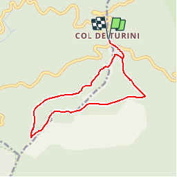
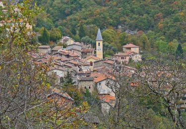
Trail Walking of 3.7 km to be discovered at Provence-Alpes-Côte d'Azur, Maritime Alps, La Bollène-Vésubie. This trail is proposed by jean.marie.litzler@gmail.com.
Description
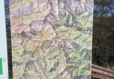
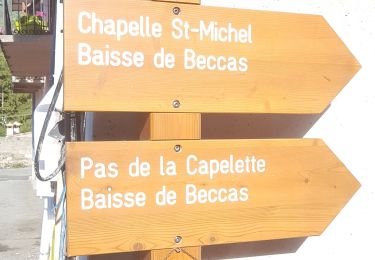
Circuit de découverte du col de Turini alternant portions en balcon et cheminement en forêt avec des points de vue privilégiés depuis les crêtes de la Calmette. Partagée entre les communes de la Bollène-Vésubie, Lantosque, Moulinet et Lucéram, l'immense forêt de conifères (pins, épicéas, sapins) qui relie le site de Turini à la station de Peïra-Cava ("pierre creuse" en provençal) recèle d'innombrables parcours pédestres sillonnant la ligne de partage des eaux entre la Vésubie et la Bévéra. Tour à tour paradis des chercheurs de champignons à l'automne, centre de ski nordique ou alpin en hiver, le col de Turini doit surtout sa réputation mythique aux rallyes automobiles qui drainent chaque année plusieurs jours durant de fervents amateurs de sensations fortes.
360m - 3h30
Positioning
Comments
Trails nearby
![Trail Walking Lantosque - cime de Suorcas en boucle - Photo](https://media.geolcdn.com/t/375/260/0ecdc4ca-4a6f-455e-849d-12769607394f.jpg&format=jpg&maxdim=2)
![Walking Walking](https://static1.geolcdn.com/sitytour/trail-icons/101.png)
Walking
![](/images/other/stat-length.png)
![](https://static1.geolcdn.com/siteimages/upload/files/16400158638029165_repeat_loop_refresh_sync_direction_icon.png)
![Trail On foot Moulinet - Crêtes de l'Arpiha - Photo](https://media.geolcdn.com/t/375/260/c07cc7b3-d5b2-4e51-bdf4-03929243643c.jpeg&format=jpg&maxdim=2)
![On foot On foot](https://static1.geolcdn.com/sitytour/trail-icons/100.png)
On foot
![](/images/other/stat-length.png)
![](https://static1.geolcdn.com/siteimages/upload/files/16400158638029165_repeat_loop_refresh_sync_direction_icon.png)
![Trail On foot Moulinet - Tour de la Calmette - Photo](https://media.geolcdn.com/t/375/260/f1319e6f-f58e-4543-ba7d-7f850f27f51a.jpeg&format=jpg&maxdim=2)
![On foot On foot](https://static1.geolcdn.com/sitytour/trail-icons/100.png)
On foot
![](/images/other/stat-length.png)
![](https://static1.geolcdn.com/siteimages/upload/files/16400158638029165_repeat_loop_refresh_sync_direction_icon.png)
![Trail On foot Moulinet - Cime du Diable - Photo](https://media.geolcdn.com/t/375/260/94134920-c5fc-4b95-a9f6-aeabb0ba95c2.jpeg&format=jpg&maxdim=2)
![On foot On foot](https://static1.geolcdn.com/sitytour/trail-icons/100.png)
On foot
![](/images/other/stat-length.png)
![](https://static1.geolcdn.com/siteimages/upload/files/16400158638029165_repeat_loop_refresh_sync_direction_icon.png)
![Trail Snowshoes Moulinet - Baisse Cavaline - Photo](https://media.geolcdn.com/t/375/260/b5a21962-1dcd-409b-822e-6e34602431de.jpg&format=jpg&maxdim=2)
![Snowshoes Snowshoes](https://static1.geolcdn.com/sitytour/trail-icons/504.png)
Snowshoes
![](/images/other/stat-length.png)
![](https://static1.geolcdn.com/siteimages/upload/files/16400158638029165_repeat_loop_refresh_sync_direction_icon.png)
![Trail Walking Moulinet - Grand Tour de Lauthion - Photo](https://media.geolcdn.com/t/375/260/fc421b10-23aa-4b7a-b4cf-80322f7edc29.jpg&format=jpg&maxdim=2)
![Walking Walking](https://static1.geolcdn.com/sitytour/trail-icons/101.png)
Walking
![](/images/other/stat-length.png)
![](https://static1.geolcdn.com/siteimages/upload/files/16400158638029165_repeat_loop_refresh_sync_direction_icon.png)
![Trail On foot Moulinet - Baisse de Peira Cava - Photo](https://media.geolcdn.com/t/375/260/dbec6e0a-5512-4263-b11e-6e8d3e38cd6e.jpeg&format=jpg&maxdim=2)
![On foot On foot](https://static1.geolcdn.com/sitytour/trail-icons/100.png)
On foot
![](/images/other/stat-length.png)
![](https://static1.geolcdn.com/siteimages/upload/files/16400158638029165_repeat_loop_refresh_sync_direction_icon.png)
![Trail Walking Moulinet - Turini- tour de la Calmette - Photo](https://media.geolcdn.com/t/375/260/65c623cf-7185-4ec8-a258-6191b868284a.jpg&format=jpg&maxdim=2)
![Walking Walking](https://static1.geolcdn.com/sitytour/trail-icons/101.png)
Walking
![](/images/other/stat-length.png)
![](https://static1.geolcdn.com/siteimages/upload/files/16400158638029165_repeat_loop_refresh_sync_direction_icon.png)
![Trail Walking Moulinet - Baisse de Bécass - Photo](https://media.geolcdn.com/t/375/260/10e54f39-88d4-4b84-9364-47a11d8f39f0.jpg&format=jpg&maxdim=2)
![Walking Walking](https://static1.geolcdn.com/sitytour/trail-icons/101.png)
Walking
![](/images/other/stat-length.png)
![](https://static1.geolcdn.com/siteimages/upload/files/16400158638029165_repeat_loop_refresh_sync_direction_icon.png)