Trail On foot Montbellet - Pont de Fleurville / La truchère en longeant la Saône. - Photo

Pont de Fleurville / La truchère en longeant la Saône.

© OpenStreetMap contributors
Length
Length
11.4 km
Max alt
Max alt
179 m
Uphill gradient
Uphill gradient
75 m
Km-Effort
Km-Effort  
12.4 km
Min alt
Min alt
165 m
Downhill gradient
Downhill gradient
72 m
Boucle
Boucle
No
Creation date :
2020-06-01 11:27:51.66
Updated on :
2020-06-01 11:38:42.806

(0 Reviews)

On foot
On foot
--
Difficulty : Very easy

Scan this QR Code to open this trail in the SityTrail application

FREE GPS app for hiking

Logo SityTrail SityTrail

IGN / Geographical institutes

Download SityTrail from the App Store Download SityTrail from Google Play

Logo SityTrail SityTrail World

The world is yours!

Download SityTrail from the App Store Download SityTrail from Google Play Download SityTrail on Huawei AppGallery

About

Trail On foot of 11.4 km to be discovered at Bourgogne-Franche-Comté, Saône-et-Loire, Montbellet. This trail is proposed by robertdurand.

Description

Du pont de Fleurville en passant par les lacs de Montblet, le camping d'Uchisy, la prairie nous arrivons sur les bords  de la rivière "La Seille"

Elevation profile

Positioning

Country:
France
Region :
Bourgogne-Franche-Comté
Department/Province :
Saône-et-Loire
Municipality :
Montbellet
Location:
Unknown
Start:(UTM)
645543 ; 5145566 (31T) N.

Comments

Please log in to post a review or rate the element
 

Trails nearby

Trail Walking Burgy - rando burgy - Photo
Walking
Lillie Zennily

Walking

Difficult
Burgy, Bourgogne-Franche-Comté, Saône-et-Loire, France
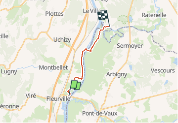
11.4 km | 16.2 km-effort
2h 37min
Yes
Trail Walking Viré - vire RST - Photo
Walking
hubert REVILLOT 2

Walking

Easy
Viré, Bourgogne-Franche-Comté, Saône-et-Loire, France
9.8 km | 13 km-effort
2h 56min
No
Trail Road bike Pont-de-Vaux - week end vélo 2024 - Photo
Road bike
lulu7469

Road bike

Very easy
Pont-de-Vaux, Auvergne-Rhône-Alpes, Ain, France
41 km | 45 km-effort
2h 28min
Yes
Trail Walking Burgy - rando clesse - Photo
Walking
liviniki

Walking

Difficult
Burgy, Bourgogne-Franche-Comté, Saône-et-Loire, France
11.2 km | 15.9 km-effort
2h 35min
Yes
Trail Walking Gorrevod - rando gorrevod - Photo
Walking
Lillie Zennily

Walking

Difficult
Gorrevod, Auvergne-Rhône-Alpes, Ain, France
15.5 km | 17.4 km-effort
2h 41min
No
Trail Walking Reyssouze - Pont de vaux - Photo
Walking
JPA GRS

Walking

Easy
Reyssouze, Auvergne-Rhône-Alpes, Ain, France
5.7 km | 6.1 km-effort
1h 31min
Yes
Trail Walking Burgy - 2022-11-23_08h00m08_Burgy 13.7km grande 21_11_22 J.D - Photo
Walking
Bcomb

Walking

Very difficult
Burgy, Bourgogne-Franche-Comté, Saône-et-Loire, France
13.7 km | 19.3 km-effort
4h 23min
Yes
Trail Walking Viré - vire - Photo
Walking
JPA GRS

Walking

Easy
Viré, Bourgogne-Franche-Comté, Saône-et-Loire, France
5 km | 5.5 km-effort
1h 39min
Yes
Trail Nordic walking Viré - Viré - Photo
Nordic walking
danylucien

Nordic walking

Viré, Bourgogne-Franche-Comté, Saône-et-Loire, France
9.5 km | 12.4 km-effort
2h 30min
Yes


Close
My subscriptions