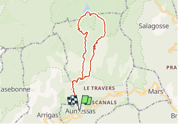
Trail Walking Aumessas - Gard - Aumessas Lac des Pises 17km 958m - Photo

Gard - Aumessas Lac des Pises 17km 958m

 RandoVal
RandoVal

User

© OpenStreetMap contributors
Length
Length
16.7 km
Max alt
Max alt
1332 m
Uphill gradient
Uphill gradient
975 m
Km-Effort
Km-Effort  
30 km
Min alt
Min alt
456 m
Downhill gradient
Downhill gradient
974 m
Boucle
Boucle
Yes
Creation date :
2020-06-01 06:00:14.207
Updated on :
2020-06-01 16:51:03.141

(0 Reviews)

Walking
Walking
--
Difficulty : Unknown

Scan this QR Code to open this trail in the SityTrail application

FREE GPS app for hiking

Logo SityTrail SityTrail

IGN / Geographical institutes

Download SityTrail from the App Store Download SityTrail from Google Play

Logo SityTrail SityTrail World

The world is yours!

Download SityTrail from the App Store Download SityTrail from Google Play Download SityTrail on Huawei AppGallery

About

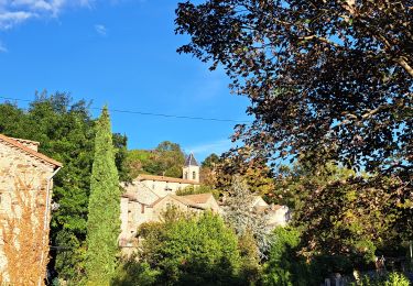
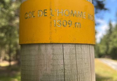
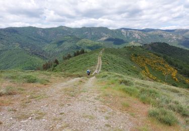
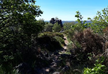
Trail Walking of 16.7 km to be discovered at Occitania, Gard, Aumessas. This trail is proposed by RandoVal.

Description

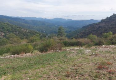
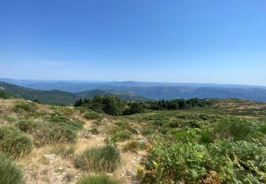
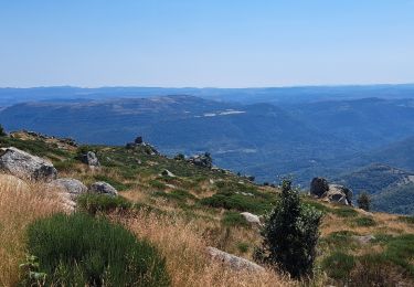
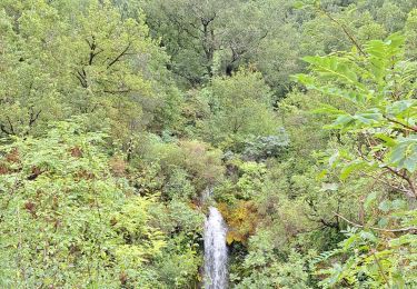
Rando en boucle au départ d'Aumessas vers le lac des Pises. Parking et départ sous les arbres sur l'ancienne voie ferrée, sens horaire. Belle Montée. Le pique-nique au bord du lac est cool. Au retour on fait la descente le long du torrent.

Elevation profile

Positioning

Country:
France
Region :
Occitania
Department/Province :
Gard
Municipality :
Aumessas
Location:
Unknown
Start:(UTM)
540333 ; 4871014 (31T) N.

Trails nearby

Trail Walking Aumessas - Lac les Pisés départ Travers - Photo
Walking
GUIDE
Roger Philippe Wallez

Walking

Very difficult
Aumessas, Occitania, Gard, France
16.3 km | 27 km-effort
6h 35min
Yes
Trail Walking Aumessas - Lac de Pises au départ Le Travers - Photo
Walking
GUIDE
nadinebondoux

Walking

Difficult
Aumessas, Occitania, Gard, France
16.7 km | 27 km-effort
7h 13min
Yes
Trail Walking Arre - Vallée de l'Arre - Photo
Walking
GUIDE
nadinebondoux

Walking

Medium
Arre, Occitania, Gard, France
17.7 km | 25 km-effort
5h 57min
Yes
Trail Walking Arrigas - Col de l’Homme mort  le Saint Guiral - Photo
Walking
boudpn

Walking

Difficult
Arrigas, Occitania, Gard, France
9.9 km | 13 km-effort
4h 11min
Yes
Trail Walking Alzon - vers le St guiral puis le rocher de l'aigle - Photo
Walking
labarone

Walking

Difficult
Alzon, Occitania, Gard, France
17.7 km | 29 km-effort
6h 51min
Yes
Trail Walking Aumessas - Aumessas-27-05-21 - Photo
Walking
Christiancordin

Walking

Medium
Aumessas, Occitania, Gard, France
11.8 km | 20 km-effort
4h 51min
Yes
Trail Walking Arrigas - de Arrigas au Mont saint Guiral - Photo
Walking
labarone

Walking

Medium
Arrigas, Occitania, Gard, France
22 km | 35 km-effort
5h 35min
Yes
Trail Walking Alzon - Alzon-Cazebonne - Photo
Walking
JEANJOSY

Walking

Easy
Alzon, Occitania, Gard, France
10.7 km | 16.3 km-effort
3h 54min
Yes
Trail Walking Alzon - Alzon-Cazebonne - Photo
Walking
JEANJOSY

Walking

Easy
Alzon, Occitania, Gard, France
10.7 km | 16.3 km-effort
3h 54min
Yes


Close
My subscriptions