![](/images/other/stat-length.png)
![Trail Electric bike Bièvre - IC: Circuit de 25km (campagne vers Vresse) départ/arrivée de l'Instant Ch'Oizy - Photo](https://media.geolcdn.com/t/1900/400/ext.pjpeg?maxdim=2&url=https%3A%2F%2Fstatic1.geolcdn.com%2Fsiteimages%2Fupload%2Ffiles%2F1524743154velo.jpg)
IC: Circuit de 25km (campagne vers Vresse) départ/arrivée de l'Instant Ch'Oizy
papadoc
User
![Length](/images/other/stat-length.png)
Length
24 km
![Max alt](https://static1.geolcdn.com/siteimages/upload/files/1508320355ic_sort_altitude_max_24dp.png)
Max alt
415 m
![Uphill gradient](https://static1.geolcdn.com/siteimages/upload/files/1508320355ic_sort_den_pos_24dp.png)
Uphill gradient
528 m
![Km-Effort](/images/other/stat-length.png)
Km-Effort
31 km
![Min alt](https://static1.geolcdn.com/siteimages/upload/files/1508320355ic_sort_altitude_min_24dp.png)
Min alt
185 m
![Downhill gradient](https://static1.geolcdn.com/siteimages/upload/files/1508320355ic_sort_den_neg_24dp.png)
Downhill gradient
526 m
![Boucle](https://static1.geolcdn.com/siteimages/upload/files/16400158638029165_repeat_loop_refresh_sync_direction_icon.png)
Boucle
Yes
Creation date :
2020-05-29 20:41:51.627
Updated on :
2020-05-29 20:42:20.652
![Electric bike](https://static1.geolcdn.com/sitytour/trail-icons/205.png)
--
Difficulty : Medium
![Scan this QR Code to open this trail in the SityTrail application](https://capi.geolives.com/qq0zvz2zws4bq2lad0pu/sitytour/trails/2416463/qr.png?size=200)
FREE GPS app for hiking
About
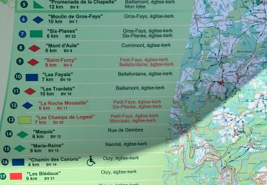
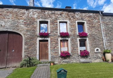
Trail Electric bike of 24 km to be discovered at Wallonia, Namur, Bièvre. This trail is proposed by papadoc.
Description
Très jolie promenade en boucle (25km) départ et arrivée à L'Instant Ch'Oizy Idéale pour essayer le vélo électrique pendant un petit séjour à Oizy Passage par - La vallée du Ruaumoulin (très jolie vallée avec un ruisseau à longer) - Vresse sur Semois (avec restaurants et bars)
Positioning
Country:
Belgium
Region :
Wallonia
Department/Province :
Namur
Municipality :
Bièvre
Location:
Oizy
Start:(Dec)
Start:(UTM)
644703 ; 5528817 (31U) N.
Comments
Trails nearby
![Walking Walking](https://static1.geolcdn.com/sitytour/trail-icons/101.png)
RB-Na-31-Un pays d’étangs et de pépinières
Walking
Very difficult
(5)
Bièvre,
Wallonia,
Namur,
Belgium
![](/images/other/stat-length.png)
21 km | 27 km-effort
6h 14min
![](https://static1.geolcdn.com/siteimages/upload/files/16400158638029165_repeat_loop_refresh_sync_direction_icon.png)
Yes
![Trail Walking Bouillon - RB-Lu-12 - Premier contact avec la Semois au Tombeau du Géant - Photo](https://media.geolcdn.com/t/375/260/ext.jpg?maxdim=2&url=https%3A%2F%2Fservices.sitytrail.com%2FGeolivesWS%2FDownloadMedia.ashx%3FTrailID%3D179617%26Media%3Dd1ff11f2-43fb-4a27-8679-182dbfec36f0.jpg)
![Walking Walking](https://static1.geolcdn.com/sitytour/trail-icons/101.png)
RB-Lu-12 - Premier contact avec la Semois au Tombeau du Géant
Walking
Very difficult
(6)
Bouillon,
Wallonia,
Luxembourg,
Belgium
![](/images/other/stat-length.png)
19.1 km | 27 km-effort
6h 7min
![](https://static1.geolcdn.com/siteimages/upload/files/16400158638029165_repeat_loop_refresh_sync_direction_icon.png)
Yes
![Walking Walking](https://static1.geolcdn.com/sitytour/trail-icons/101.png)
RB-Na-31-Racc_Un-pays-d’étangs-et-de-pépinières
Walking
Very difficult
(2)
Bièvre,
Wallonia,
Namur,
Belgium
![](/images/other/stat-length.png)
16.1 km | 21 km-effort
4h 49min
![](https://static1.geolcdn.com/siteimages/upload/files/16400158638029165_repeat_loop_refresh_sync_direction_icon.png)
Yes
![Trail Walking Bièvre - La roche mouselle bv11 - Photo](https://media.geolcdn.com/t/375/260/180021d9-3dfc-4c34-835a-76474bb7f028.jpg&format=jpg&maxdim=2)
![Walking Walking](https://static1.geolcdn.com/sitytour/trail-icons/101.png)
La roche mouselle bv11
Walking
Easy
(2)
Bièvre,
Wallonia,
Namur,
Belgium
![](/images/other/stat-length.png)
5.5 km | 7.2 km-effort
1h 27min
![](https://static1.geolcdn.com/siteimages/upload/files/16400158638029165_repeat_loop_refresh_sync_direction_icon.png)
Yes
![Trail Walking Bièvre - Promenade de la Roche Mouselle - Petit-Fays - Photo](https://media.geolcdn.com/t/375/260/501e45df-6a5c-4127-b2f5-d1b068aa8215.jpg&format=jpg&maxdim=2)
![Walking Walking](https://static1.geolcdn.com/sitytour/trail-icons/101.png)
Promenade de la Roche Mouselle - Petit-Fays
Walking
Medium
Bièvre,
Wallonia,
Namur,
Belgium
![](/images/other/stat-length.png)
5.5 km | 7.2 km-effort
1h 38min
![](https://static1.geolcdn.com/siteimages/upload/files/16400158638029165_repeat_loop_refresh_sync_direction_icon.png)
Yes
![Trail Walking Paliseul - Marche ADEPS à Carlbourg. 9 km 200 - Photo](https://media.geolcdn.com/t/375/260/bea0c187-f0c2-4e7c-8aec-60125f26f246.jpg&format=jpg&maxdim=2)
![Walking Walking](https://static1.geolcdn.com/sitytour/trail-icons/101.png)
Marche ADEPS à Carlbourg. 9 km 200
Walking
Medium
Paliseul,
Wallonia,
Luxembourg,
Belgium
![](/images/other/stat-length.png)
9.4 km | 12 km-effort
1h 56min
![](https://static1.geolcdn.com/siteimages/upload/files/16400158638029165_repeat_loop_refresh_sync_direction_icon.png)
Yes
![Trail Walking Vresse-sur-Semois - Balade à Chairière - Vresse sur Semois - Photo](https://media.geolcdn.com/t/375/260/2c06f16b-5f0e-4b3d-b0ba-5f1b1ecacfff.jpeg&format=jpg&maxdim=2)
![Walking Walking](https://static1.geolcdn.com/sitytour/trail-icons/101.png)
Balade à Chairière - Vresse sur Semois
Walking
Difficult
(2)
Vresse-sur-Semois,
Wallonia,
Namur,
Belgium
![](/images/other/stat-length.png)
10.9 km | 14.7 km-effort
3h 20min
![](https://static1.geolcdn.com/siteimages/upload/files/16400158638029165_repeat_loop_refresh_sync_direction_icon.png)
Yes
![Trail Walking Bièvre - Balade à Bellefontaine - Bièvre - Photo](https://media.geolcdn.com/t/375/260/479b792a-217f-4a9c-be19-91532b972e2a.jpeg&format=jpg&maxdim=2)
![Walking Walking](https://static1.geolcdn.com/sitytour/trail-icons/101.png)
Balade à Bellefontaine - Bièvre
Walking
Difficult
Bièvre,
Wallonia,
Namur,
Belgium
![](/images/other/stat-length.png)
10 km | 12.9 km-effort
2h 56min
![](https://static1.geolcdn.com/siteimages/upload/files/16400158638029165_repeat_loop_refresh_sync_direction_icon.png)
Yes
![Trail Walking Paliseul - Marche ADEPS 10KM500 à Carlsbourg - Photo](https://media.geolcdn.com/t/375/260/68707cc8-4f4e-4044-881a-06d21ba7fd02.jpg&format=jpg&maxdim=2)
![Walking Walking](https://static1.geolcdn.com/sitytour/trail-icons/101.png)
Marche ADEPS 10KM500 à Carlsbourg
Walking
Easy
Paliseul,
Wallonia,
Luxembourg,
Belgium
![](/images/other/stat-length.png)
10.2 km | 12.7 km-effort
2h 2min
![](https://static1.geolcdn.com/siteimages/upload/files/16400158638029165_repeat_loop_refresh_sync_direction_icon.png)
Yes