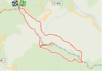
![](/images/other/stat-length.png)
![Trail Walking Osse-en-Aspe - Soum de Pirait - Photo](https://media.geolcdn.com/t/1900/400/df75ce45-3c33-44f8-949f-5e9cde571389.jpg&format=pjpeg&maxdim=2)
Soum de Pirait
bedous
User
![Length](/images/other/stat-length.png)
![Max alt](https://static1.geolcdn.com/siteimages/upload/files/1508320355ic_sort_altitude_max_24dp.png)
![Uphill gradient](https://static1.geolcdn.com/siteimages/upload/files/1508320355ic_sort_den_pos_24dp.png)
![Km-Effort](/images/other/stat-length.png)
![Min alt](https://static1.geolcdn.com/siteimages/upload/files/1508320355ic_sort_altitude_min_24dp.png)
![Downhill gradient](https://static1.geolcdn.com/siteimages/upload/files/1508320355ic_sort_den_neg_24dp.png)
![Boucle](https://static1.geolcdn.com/siteimages/upload/files/16400158638029165_repeat_loop_refresh_sync_direction_icon.png)
![Walking](https://static1.geolcdn.com/sitytour/trail-icons/101.png)
2h26
Difficulty : Easy
![Scan this QR Code to open this trail in the SityTrail application](https://capi.geolives.com/qq0zvz2zws4bq2lad0pu/sitytour/trails/2415571/qr.png?size=200)
FREE GPS app for hiking
About
Trail Walking of 5.9 km to be discovered at New Aquitaine, Pyrénées-Atlantiques, Osse-en-Aspe. This trail is proposed by bedous.
Description
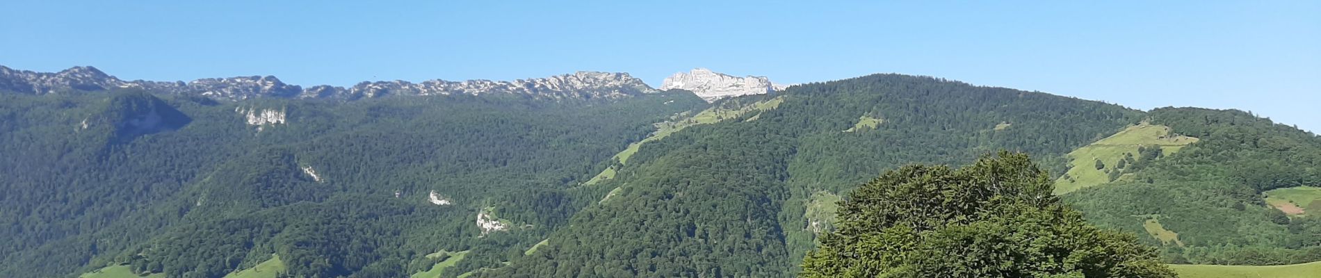
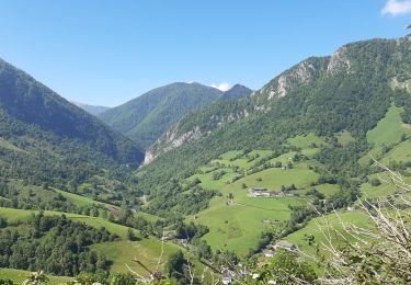
Rando dans le sens inverse des aiguilles. Du soum une magnifique vue sur la vallée d'aspe et les environs. Puis le sentier descend à travers des estives , deux fontaines sont rencontrées, la "bourissère" est trés agréable pour une pause à l'ombre avec des sièges naturels.
le 29.05.2020 le retour a été effectué par une route forestière non entretenue et envahie par la végétation ( contrôler son état avant de s'y engager et s'y nécessaire faire demi-tour. L'aller-retour est tout de même trés abréable à effectuer.
Positioning
Comments
Trails nearby
![Trail Walking Accous - ACCOUS Chapelle San Christau](https://media.geolcdn.com/t/375/260/40c2b7e8-ffbe-4c46-b83e-62c3011b6688.jpg&format=jpg&maxdim=2)
![Walking Walking](https://static1.geolcdn.com/sitytour/trail-icons/101.png)
Walking
![](/images/other/stat-length.png)
![](https://static1.geolcdn.com/siteimages/upload/files/16400158638029165_repeat_loop_refresh_sync_direction_icon.png)
![Trail Walking Lourdios-Ichère - Circuit les fougeraies lourdios-Ichère - Photo](https://media.geolcdn.com/t/375/260/7fb0581a-0f2a-4a22-aa40-0e0fe8fcd4ed.jpg&format=jpg&maxdim=2)
![Walking Walking](https://static1.geolcdn.com/sitytour/trail-icons/101.png)
Walking
![](/images/other/stat-length.png)
![](https://static1.geolcdn.com/siteimages/upload/files/16400158638029165_repeat_loop_refresh_sync_direction_icon.png)
![Trail Walking Bedous - Le Tour de Saudious - Photo](https://media.geolcdn.com/t/375/260/ext.jpg?maxdim=2&url=https%3A%2F%2Fservices.sitytrail.com%2FGeolivesWS%2FDownloadMedia.ashx%3FTrailID%3D110248%26Media%3D5551_6.jpg)
![Walking Walking](https://static1.geolcdn.com/sitytour/trail-icons/101.png)
Walking
![](/images/other/stat-length.png)
![](https://static1.geolcdn.com/siteimages/upload/files/16400158638029165_repeat_loop_refresh_sync_direction_icon.png)
![Trail Walking Bedous - BEDOUS le tour du Pouey autrement](https://media.geolcdn.com/t/375/260/03231525-2563-4126-84d1-fc81f72a3b22.jpg&format=jpg&maxdim=2)
![Walking Walking](https://static1.geolcdn.com/sitytour/trail-icons/101.png)
Walking
![](/images/other/stat-length.png)
![](https://static1.geolcdn.com/siteimages/upload/files/16400158638029165_repeat_loop_refresh_sync_direction_icon.png)
![Trail On foot Bedous - BEDOUS les chemins du gaves G4](https://media.geolcdn.com/t/375/260/9e91315c-b4be-4963-9ba8-48016c7d9f89.jpg&format=jpg&maxdim=2)
![On foot On foot](https://static1.geolcdn.com/sitytour/trail-icons/100.png)
On foot
![](/images/other/stat-length.png)
![](https://static1.geolcdn.com/siteimages/upload/files/16400158638029165_repeat_loop_refresh_sync_direction_icon.png)
![On foot On foot](https://static1.geolcdn.com/sitytour/trail-icons/100.png)
On foot
![](/images/other/stat-length.png)
![](https://static1.geolcdn.com/siteimages/upload/files/16400158638029165_repeat_loop_refresh_sync_direction_icon.png)
![Trail On foot Accous - Sommet du Poey asp122 - Photo](https://media.geolcdn.com/t/375/260/2d07cf2c-8954-4ab2-916e-821bbcb77891.jpeg&format=jpg&maxdim=2)
![On foot On foot](https://static1.geolcdn.com/sitytour/trail-icons/100.png)
On foot
![](/images/other/stat-length.png)
![](https://static1.geolcdn.com/siteimages/upload/files/16400158638029165_repeat_loop_refresh_sync_direction_icon.png)
![Trail On foot Osse-en-Aspe - Tour panoramique Osse-Athas asp109 - Photo](https://media.geolcdn.com/t/375/260/fd742eea-9420-4aa3-9b7d-11c6f4a57c86.jpeg&format=jpg&maxdim=2)
![On foot On foot](https://static1.geolcdn.com/sitytour/trail-icons/100.png)
On foot
![](/images/other/stat-length.png)
![](https://static1.geolcdn.com/siteimages/upload/files/16400158638029165_repeat_loop_refresh_sync_direction_icon.png)
![Trail On foot Bedous - Chemins du Gave asp12 - Photo](https://media.geolcdn.com/t/375/260/ec883c8e-b059-451f-9259-f3928d0e390d.jpeg&format=jpg&maxdim=2)
![On foot On foot](https://static1.geolcdn.com/sitytour/trail-icons/100.png)
On foot
![](/images/other/stat-length.png)
![](https://static1.geolcdn.com/siteimages/upload/files/16400158638029165_repeat_loop_refresh_sync_direction_icon.png)