![](/images/other/stat-length.png)
![Trail Electric bike Doische - La vallée du Viroin et la Calestienne - Photo](https://media.geolcdn.com/t/1900/400/ext.pjpeg?maxdim=2&url=https%3A%2F%2Fstatic1.geolcdn.com%2Fsiteimages%2Fupload%2Ffiles%2F1524743154velo.jpg)
La vallée du Viroin et la Calestienne
papadoc
User
![Length](/images/other/stat-length.png)
Length
55 km
![Max alt](https://static1.geolcdn.com/siteimages/upload/files/1508320355ic_sort_altitude_max_24dp.png)
Max alt
363 m
![Uphill gradient](https://static1.geolcdn.com/siteimages/upload/files/1508320355ic_sort_den_pos_24dp.png)
Uphill gradient
854 m
![Km-Effort](/images/other/stat-length.png)
Km-Effort
66 km
![Min alt](https://static1.geolcdn.com/siteimages/upload/files/1508320355ic_sort_altitude_min_24dp.png)
Min alt
123 m
![Downhill gradient](https://static1.geolcdn.com/siteimages/upload/files/1508320355ic_sort_den_neg_24dp.png)
Downhill gradient
855 m
![Boucle](https://static1.geolcdn.com/siteimages/upload/files/16400158638029165_repeat_loop_refresh_sync_direction_icon.png)
Boucle
Yes
Creation date :
2020-05-29 12:53:29.437
Updated on :
2020-05-29 12:54:10.123
![Electric bike](https://static1.geolcdn.com/sitytour/trail-icons/205.png)
--
Difficulty : Medium
![Scan this QR Code to open this trail in the SityTrail application](https://capi.geolives.com/qq0zvz2zws4bq2lad0pu/sitytour/trails/2415553/qr.png?size=200)
FREE GPS app for hiking
About
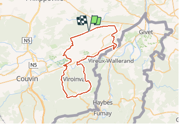
Trail Electric bike of 55 km to be discovered at Wallonia, Namur, Doische. This trail is proposed by papadoc.
Description
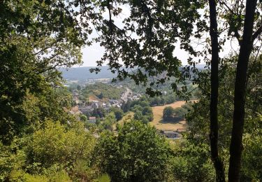
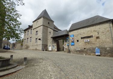
Magnifique boucle à la découverte de la Calestienne, entre Fagne et Ardenne, très variée tant au niveau des routes empruntées (RAVeL - bois - campagne - forêts) que des bijoux à traverser (par ex. Vierves-sur-Viroin en Belgique et Hierges en France).
Positioning
Country:
Belgium
Region :
Wallonia
Department/Province :
Namur
Municipality :
Doische
Location:
Unknown
Start:(Dec)
Start:(UTM)
619199 ; 5555118 (31U) N.
Comments
Trails nearby
![Trail Walking Viroinval - RB-Na-12 Ed4 Balade franco-belge chez Toine Culot - Photo](https://media.geolcdn.com/t/375/260/ext.jpg?maxdim=2&url=https%3A%2F%2Fservices.sitytrail.com%2FGeolivesWS%2FDownloadMedia.ashx%3FTrailID%3D794212%26Media%3D5fba0928-65b8-4f08-8244-3dd1e2295f4a.jpg)
![Walking Walking](https://static1.geolcdn.com/sitytour/trail-icons/101.png)
RB-Na-12 Ed4 Balade franco-belge chez Toine Culot
Walking
Medium
(3)
Viroinval,
Wallonia,
Namur,
Belgium
![](/images/other/stat-length.png)
14.8 km | 21 km-effort
6h 13min
![](https://static1.geolcdn.com/siteimages/upload/files/16400158638029165_repeat_loop_refresh_sync_direction_icon.png)
Yes
![Trail Walking Viroinval - Mazée, sur le sentier des Douaniers - Photo](https://media.geolcdn.com/t/375/260/e6a3fc86-55fd-4ddf-a6e6-df3228867288.jpg&format=jpg&maxdim=2)
![Walking Walking](https://static1.geolcdn.com/sitytour/trail-icons/101.png)
Mazée, sur le sentier des Douaniers
Walking
Very easy
(1)
Viroinval,
Wallonia,
Namur,
Belgium
![](/images/other/stat-length.png)
7.6 km | 10.5 km-effort
4h 2min
![](https://static1.geolcdn.com/siteimages/upload/files/16400158638029165_repeat_loop_refresh_sync_direction_icon.png)
Yes
![Trail Walking Doische - Promenade à Vodelée - Photo](https://media.geolcdn.com/t/375/260/ext.jpg?maxdim=2&url=https%3A%2F%2Fstatic1.geolcdn.com%2Fsiteimages%2Fupload%2Ffiles%2F1553511878bg_sport_marche.png)
![Walking Walking](https://static1.geolcdn.com/sitytour/trail-icons/101.png)
Promenade à Vodelée
Walking
Easy
(1)
Doische,
Wallonia,
Namur,
Belgium
![](/images/other/stat-length.png)
9.3 km | 11.4 km-effort
2h 15min
![](https://static1.geolcdn.com/siteimages/upload/files/16400158638029165_repeat_loop_refresh_sync_direction_icon.png)
Yes
![Trail On foot Viroinval - La Villa Gallo-Romaine - Photo](https://media.geolcdn.com/t/375/260/0fbc23cb-6394-4025-9f50-97c9c9ed0621.jpeg&format=jpg&maxdim=2)
![On foot On foot](https://static1.geolcdn.com/sitytour/trail-icons/100.png)
La Villa Gallo-Romaine
On foot
Easy
Viroinval,
Wallonia,
Namur,
Belgium
![](/images/other/stat-length.png)
3.7 km | 4.5 km-effort
1h 1min
![](https://static1.geolcdn.com/siteimages/upload/files/16400158638029165_repeat_loop_refresh_sync_direction_icon.png)
Yes
![Trail On foot Viroinval - Pré Aigret - Photo](https://media.geolcdn.com/t/375/260/0fbc23cb-6394-4025-9f50-97c9c9ed0621.jpeg&format=jpg&maxdim=2)
![On foot On foot](https://static1.geolcdn.com/sitytour/trail-icons/100.png)
![Trail On foot Viroinval - Les Rivelottes - Photo](https://media.geolcdn.com/t/375/260/0fbc23cb-6394-4025-9f50-97c9c9ed0621.jpeg&format=jpg&maxdim=2)
![On foot On foot](https://static1.geolcdn.com/sitytour/trail-icons/100.png)
![Trail On foot Viroinval - Les Elmonts - Photo](https://media.geolcdn.com/t/375/260/0fbc23cb-6394-4025-9f50-97c9c9ed0621.jpeg&format=jpg&maxdim=2)
![On foot On foot](https://static1.geolcdn.com/sitytour/trail-icons/100.png)
![Trail On foot Viroinval - Les Carrièrres - Photo](https://media.geolcdn.com/t/375/260/0fbc23cb-6394-4025-9f50-97c9c9ed0621.jpeg&format=jpg&maxdim=2)
![On foot On foot](https://static1.geolcdn.com/sitytour/trail-icons/100.png)
![Trail On foot Viroinval - Le Fond de Chaule - Photo](https://media.geolcdn.com/t/375/260/0fbc23cb-6394-4025-9f50-97c9c9ed0621.jpeg&format=jpg&maxdim=2)
![On foot On foot](https://static1.geolcdn.com/sitytour/trail-icons/100.png)
Le Fond de Chaule
On foot
Easy
Viroinval,
Wallonia,
Namur,
Belgium
![](/images/other/stat-length.png)
7.6 km | 9.7 km-effort
2h 12min
![](https://static1.geolcdn.com/siteimages/upload/files/16400158638029165_repeat_loop_refresh_sync_direction_icon.png)
Yes
Très belle randonnée ! Batteries bien chargées !