Trail On foot Vaugneray - Saint-Laurent-de-Vaux (69) - la Haute Bruyère - Photo

Saint-Laurent-de-Vaux (69) - la Haute Bruyère

© OpenStreetMap contributors
Length
Length
8.7 km
Max alt
Max alt
607 m
Uphill gradient
Uphill gradient
366 m
Km-Effort
Km-Effort  
13.5 km
Min alt
Min alt
419 m
Downhill gradient
Downhill gradient
366 m
Boucle
Boucle
Yes
Creation date :
2020-05-26 16:51:01.176
Updated on :
2020-05-26 16:53:06.426

(0 Reviews)

On foot
On foot
--
Difficulty : Medium

Scan this QR Code to open this trail in the SityTrail application

FREE GPS app for hiking

Logo SityTrail SityTrail

IGN / Geographical institutes

Download SityTrail from the App Store Download SityTrail from Google Play

Logo SityTrail SityTrail World

The world is yours!

Download SityTrail from the App Store Download SityTrail from Google Play Download SityTrail on Huawei AppGallery

About

Trail On foot of 8.7 km to be discovered at Auvergne-Rhône-Alpes, Rhône, Vaugneray. This trail is proposed by vazitonton.

Description

Cette jolie boucle facile au départ de Saint-Laurent-de-Vaux vous mènera sur d'agréables sentiers essentiellement en forêt. Si le temps est bien dégagé, la vue depuis le plateau du Plat Saint- Romain vous offrira un superbe panorama sur la chaîne des Alpes

Elevation profile

Positioning

Country:
France
Region :
Auvergne-Rhône-Alpes
Department/Province :
Rhône
Municipality :
Vaugneray
Location:
Saint-Laurent-de-Vaux
Start:(UTM)
626967 ; 5063681 (31T) N.

Trails nearby

Trail Walking Messimy - De Messimy au belvédère du Piragoy en boucle - Photo
Walking
galain

Walking

Easy
(1)
Messimy, Auvergne-Rhône-Alpes, Rhône, France
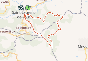
9.6 km | 13.6 km-effort
2h 31min
Yes
Trail Walking Thurins - tour du bois du baron - Photo
Walking
godbillon

Walking

Easy
(3)
Thurins, Auvergne-Rhône-Alpes, Rhône, France
7.4 km | 11.5 km-effort
1h 40min
Yes
Trail Walking Vaugneray - Sur les hauteurs de Vaugneray - Photo
Walking
tracegps

Walking

Medium
(4)
Vaugneray, Auvergne-Rhône-Alpes, Rhône, France
12.5 km | 19.2 km-effort
4h 0min
Yes
Trail Walking Courzieu - 2023-05-11_18h58m29_Fiche Verte n°5_Courzieu - Photo
Walking
daniellebou

Walking

Difficult
(1)
Courzieu, Auvergne-Rhône-Alpes, Rhône, France
9 km | 15 km-effort
3h 23min
Yes
Trail Walking Vaugneray - Vaugneray - Lac D'Yseron- Parc Animalier de Courzieu - Photo
Walking
jacques delaporte

Walking

Very difficult
(1)
Vaugneray, Auvergne-Rhône-Alpes, Rhône, France
38 km | 58 km-effort
13h 13min
Yes
Trail Mountain bike Vaugneray - Belle boucle!  800m sur 24kms. - Photo
Mountain bike
dup69

Mountain bike

Medium
(1)
Vaugneray, Auvergne-Rhône-Alpes, Rhône, France
25 km | 36 km-effort
3h 0min
Yes
Trail Mountain bike Messimy - monté technique - Photo
Mountain bike
journoud

Mountain bike

Difficult
(1)
Messimy, Auvergne-Rhône-Alpes, Rhône, France
26 km | 41 km-effort
3h 15min
Yes
Trail Mountain bike Vaugneray - VTT VAUGNERAY - Photo
Mountain bike
skwick

Mountain bike

Difficult
(1)
Vaugneray, Auvergne-Rhône-Alpes, Rhône, France
17.4 km | 26 km-effort
Unknown
Yes
Trail Mountain bike Grézieu-la-Varenne - scott25 - Photo
Mountain bike
bernardberard

Mountain bike

Very easy
(1)
Grézieu-la-Varenne, Auvergne-Rhône-Alpes, Rhône, France
26 km | 37 km-effort
Unknown
Yes


Close
My subscriptions