![](/images/other/stat-length.png)
![Trail Walking Bouvante - Serre Montué par la grotte du Berger, la pas de l'Infernet en circuit partiel - Photo](https://media.geolcdn.com/t/1900/400/9df202a1-b6fd-4969-9f66-0e28edea6fcb.jpg&format=pjpeg&maxdim=2)
Serre Montué par la grotte du Berger, la pas de l'Infernet en circuit partiel
Emelle
User
![Length](/images/other/stat-length.png)
Length
8.9 km
![Max alt](https://static1.geolcdn.com/siteimages/upload/files/1508320355ic_sort_altitude_max_24dp.png)
Max alt
1697 m
![Uphill gradient](https://static1.geolcdn.com/siteimages/upload/files/1508320355ic_sort_den_pos_24dp.png)
Uphill gradient
452 m
![Km-Effort](/images/other/stat-length.png)
Km-Effort
15 km
![Min alt](https://static1.geolcdn.com/siteimages/upload/files/1508320355ic_sort_altitude_min_24dp.png)
Min alt
1433 m
![Downhill gradient](https://static1.geolcdn.com/siteimages/upload/files/1508320355ic_sort_den_neg_24dp.png)
Downhill gradient
454 m
![Boucle](https://static1.geolcdn.com/siteimages/upload/files/16400158638029165_repeat_loop_refresh_sync_direction_icon.png)
Boucle
Yes
Creation date :
2020-05-25 08:48:55.711
Updated on :
2021-02-03 14:22:50.801
![Walking](https://static1.geolcdn.com/sitytour/trail-icons/101.png)
4h48
Difficulty : Difficult
![Scan this QR Code to open this trail in the SityTrail application](https://capi.geolives.com/qq0zvz2zws4bq2lad0pu/sitytour/trails/2410715/qr.png?size=200)
FREE GPS app for hiking
About
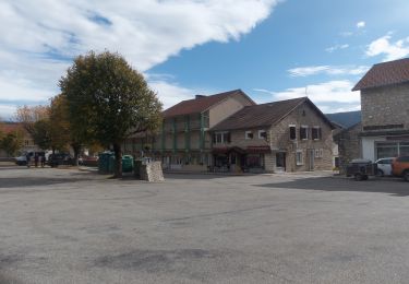
Trail Walking of 8.9 km to be discovered at Auvergne-Rhône-Alpes, Drôme, Bouvante. This trail is proposed by Emelle.
Description
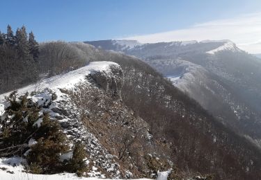
Sortie de la grotte et remontée sur le plateau délicate, aérienne nécessitant un pied sûr. Aucune difficulté pour le reste même si l'accès au sommet est hors sentier balisé. Très beau point de vue au sommet.
Positioning
Country:
France
Region :
Auvergne-Rhône-Alpes
Department/Province :
Drôme
Municipality :
Bouvante
Location:
Unknown
Start:(Dec)
Start:(UTM)
683198 ; 4974221 (31T) N.
Comments
Trails nearby
![Trail Snowshoes Bouvante - Les gagères en raquettes - Photo](https://media.geolcdn.com/t/375/260/2981cf80-2281-48d0-9011-dd17ca071224.jpg&format=jpg&maxdim=2)
![Snowshoes Snowshoes](https://static1.geolcdn.com/sitytour/trail-icons/504.png)
Les gagères en raquettes
Snowshoes
Medium
(1)
Bouvante,
Auvergne-Rhône-Alpes,
Drôme,
France
![](/images/other/stat-length.png)
9.2 km | 14.2 km-effort
3h 40min
![](https://static1.geolcdn.com/siteimages/upload/files/16400158638029165_repeat_loop_refresh_sync_direction_icon.png)
Yes
![Trail Walking Bouvante - 01 - Photo](https://media.geolcdn.com/t/375/260/ext.jpg?maxdim=2&url=https%3A%2F%2Fservices.sitytrail.com%2FGeolivesWS%2FDownloadMedia.ashx%3FTrailID%3D835352%26Media%3Dfix__20170924162337.jpg)
![Walking Walking](https://static1.geolcdn.com/sitytour/trail-icons/101.png)
01
Walking
Medium
(1)
Bouvante,
Auvergne-Rhône-Alpes,
Drôme,
France
![](/images/other/stat-length.png)
12.5 km | 19.5 km-effort
5h 7min
![](https://static1.geolcdn.com/siteimages/upload/files/16400158638029165_repeat_loop_refresh_sync_direction_icon.png)
Yes
![Trail Walking Bouvante - 26 bouvante pas ligue st truite - Photo](https://media.geolcdn.com/t/375/260/9494233e-7248-475d-add1-20018e6bbb97.jpg&format=jpg&maxdim=2)
![Walking Walking](https://static1.geolcdn.com/sitytour/trail-icons/101.png)
26 bouvante pas ligue st truite
Walking
Difficult
Bouvante,
Auvergne-Rhône-Alpes,
Drôme,
France
![](/images/other/stat-length.png)
18.7 km | 31 km-effort
8h 42min
![](https://static1.geolcdn.com/siteimages/upload/files/16400158638029165_repeat_loop_refresh_sync_direction_icon.png)
No
![Trail Walking La Chapelle-en-Vercors - Serre Plumé - Photo](https://media.geolcdn.com/t/375/260/86da3767-95d8-4e79-b2dd-2495b2dc9585.jpg&format=jpg&maxdim=2)
![Walking Walking](https://static1.geolcdn.com/sitytour/trail-icons/101.png)
Serre Plumé
Walking
Medium
La Chapelle-en-Vercors,
Auvergne-Rhône-Alpes,
Drôme,
France
![](/images/other/stat-length.png)
7.2 km | 11.5 km-effort
2h 42min
![](https://static1.geolcdn.com/siteimages/upload/files/16400158638029165_repeat_loop_refresh_sync_direction_icon.png)
Yes
![Trail Walking Bouvante - Boucle du Plateau de Font d'Urle - Photo](https://media.geolcdn.com/t/375/260/50aac9f1-41c9-480c-904d-17b530d5dbff.jpg&format=jpg&maxdim=2)
![Walking Walking](https://static1.geolcdn.com/sitytour/trail-icons/101.png)
Boucle du Plateau de Font d'Urle
Walking
Difficult
Bouvante,
Auvergne-Rhône-Alpes,
Drôme,
France
![](/images/other/stat-length.png)
11.2 km | 16.8 km-effort
3h 49min
![](https://static1.geolcdn.com/siteimages/upload/files/16400158638029165_repeat_loop_refresh_sync_direction_icon.png)
Yes
![Trail Walking Vassieux-en-Vercors - Vassieux-en-Vercors - Le Puy de la Gagère - Photo](https://media.geolcdn.com/t/375/260/1aad13f5-10ee-4304-b0fb-5635099ff701.jpg&format=jpg&maxdim=2)
![Walking Walking](https://static1.geolcdn.com/sitytour/trail-icons/101.png)
Vassieux-en-Vercors - Le Puy de la Gagère
Walking
Easy
Vassieux-en-Vercors,
Auvergne-Rhône-Alpes,
Drôme,
France
![](/images/other/stat-length.png)
13.1 km | 21 km-effort
3h 45min
![](https://static1.geolcdn.com/siteimages/upload/files/16400158638029165_repeat_loop_refresh_sync_direction_icon.png)
Yes
![Trail Walking Bouvante - Font d’Urle les Trois cloches Glacières les Gagères - Photo](https://media.geolcdn.com/t/375/260/d811593c-e678-4b00-a285-b7dce29eecce.jpg&format=jpg&maxdim=2)
![Walking Walking](https://static1.geolcdn.com/sitytour/trail-icons/101.png)
Font d’Urle les Trois cloches Glacières les Gagères
Walking
Difficult
Bouvante,
Auvergne-Rhône-Alpes,
Drôme,
France
![](/images/other/stat-length.png)
11.9 km | 17.9 km-effort
4h 4min
![](https://static1.geolcdn.com/siteimages/upload/files/16400158638029165_repeat_loop_refresh_sync_direction_icon.png)
Yes
![Trail Walking Vassieux-en-Vercors - But St Genis - Photo](https://media.geolcdn.com/t/375/260/7dc5994c-58ff-4977-a518-836cfc09796c.jpg&format=jpg&maxdim=2)
![Walking Walking](https://static1.geolcdn.com/sitytour/trail-icons/101.png)
But St Genis
Walking
Easy
Vassieux-en-Vercors,
Auvergne-Rhône-Alpes,
Drôme,
France
![](/images/other/stat-length.png)
12.8 km | 20 km-effort
3h 52min
![](https://static1.geolcdn.com/siteimages/upload/files/16400158638029165_repeat_loop_refresh_sync_direction_icon.png)
Yes
![Trail Walking Vassieux-en-Vercors - Forêt communale de Dié - Photo](https://media.geolcdn.com/t/375/260/81a065f0-a659-4198-8cfc-a4d3daa2067f.jpg&format=jpg&maxdim=2)
![Walking Walking](https://static1.geolcdn.com/sitytour/trail-icons/101.png)
Forêt communale de Dié
Walking
Difficult
Vassieux-en-Vercors,
Auvergne-Rhône-Alpes,
Drôme,
France
![](/images/other/stat-length.png)
10.7 km | 14.8 km-effort
3h 21min
![](https://static1.geolcdn.com/siteimages/upload/files/16400158638029165_repeat_loop_refresh_sync_direction_icon.png)
Yes