![](/images/other/stat-length.png)
![Trail Walking Saint-Pierre-de-Chandieu - 69-Saint Pierre de chandieu 18km 400m - Photo](https://media.geolcdn.com/t/1900/400/7b6850de-b07b-4775-afef-f8e49e5a4878.jpg&format=pjpeg&maxdim=2)
69-Saint Pierre de chandieu 18km 400m
SyMA
User
![Length](/images/other/stat-length.png)
Length
17.6 km
![Max alt](https://static1.geolcdn.com/siteimages/upload/files/1508320355ic_sort_altitude_max_24dp.png)
Max alt
366 m
![Uphill gradient](https://static1.geolcdn.com/siteimages/upload/files/1508320355ic_sort_den_pos_24dp.png)
Uphill gradient
401 m
![Km-Effort](/images/other/stat-length.png)
Km-Effort
23 km
![Min alt](https://static1.geolcdn.com/siteimages/upload/files/1508320355ic_sort_altitude_min_24dp.png)
Min alt
259 m
![Downhill gradient](https://static1.geolcdn.com/siteimages/upload/files/1508320355ic_sort_den_neg_24dp.png)
Downhill gradient
401 m
![Boucle](https://static1.geolcdn.com/siteimages/upload/files/16400158638029165_repeat_loop_refresh_sync_direction_icon.png)
Boucle
Yes
Creation date :
2020-05-25 06:10:07.355
Updated on :
2020-05-29 05:55:27.778
![Walking](https://static1.geolcdn.com/sitytour/trail-icons/101.png)
3h50
Difficulty : Easy
![Scan this QR Code to open this trail in the SityTrail application](https://capi.geolives.com/qq0zvz2zws4bq2lad0pu/sitytour/trails/2410336/qr.png?size=200)
FREE GPS app for hiking
About
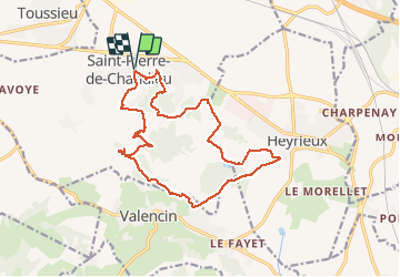
Trail Walking of 17.6 km to be discovered at Auvergne-Rhône-Alpes, Rhône, Saint-Pierre-de-Chandieu. This trail is proposed by SyMA.
Description
(reco avec passage vers remontée apres OZON (pas de chemin))
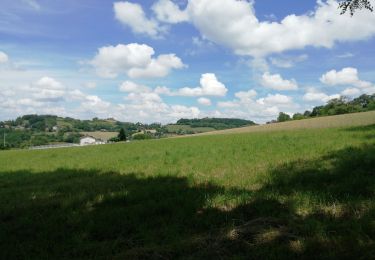
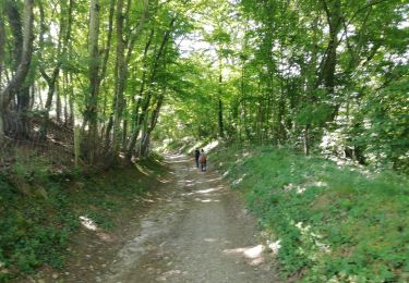
belle rando beaucoup d'ombrage et relativement peu de bitume
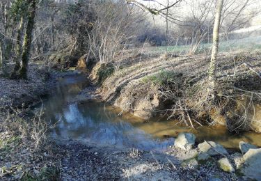
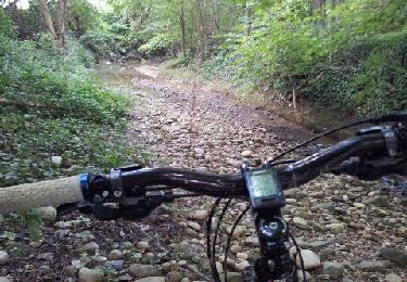
passage à gué de l'OZON
Positioning
Country:
France
Region :
Auvergne-Rhône-Alpes
Department/Province :
Rhône
Municipality :
Saint-Pierre-de-Chandieu
Location:
Unknown
Start:(Dec)
Start:(UTM)
656784 ; 5056518 (31T) N.
Comments
Trails nearby
![Trail Walking Saint-Pierre-de-Chandieu - 69-st-pierre-de-chandieu-boucle-ozon-9km - Photo](https://media.geolcdn.com/t/375/260/893760dc-b1b9-4ee1-98cb-443ac33d3041.jpg&format=jpg&maxdim=2)
![Walking Walking](https://static1.geolcdn.com/sitytour/trail-icons/101.png)
69-st-pierre-de-chandieu-boucle-ozon-9km
Walking
Easy
(1)
Saint-Pierre-de-Chandieu,
Auvergne-Rhône-Alpes,
Rhône,
France
![](/images/other/stat-length.png)
8.6 km | 10.5 km-effort
2h 8min
![](https://static1.geolcdn.com/siteimages/upload/files/16400158638029165_repeat_loop_refresh_sync_direction_icon.png)
Yes
![Trail Walking Toussieu - 69 Toussieu poypes 2 vallons 21km 420m - Photo](https://media.geolcdn.com/t/375/260/9791a08c-19f2-4a10-84d0-f188f7daef8a.jpg&format=jpg&maxdim=2)
![Walking Walking](https://static1.geolcdn.com/sitytour/trail-icons/101.png)
69 Toussieu poypes 2 vallons 21km 420m
Walking
Medium
Toussieu,
Auvergne-Rhône-Alpes,
Rhône,
France
![](/images/other/stat-length.png)
21 km | 27 km-effort
5h 54min
![](https://static1.geolcdn.com/siteimages/upload/files/16400158638029165_repeat_loop_refresh_sync_direction_icon.png)
Yes
![Trail Walking Saint-Pierre-de-Chandieu - 69-Saint Pierre de Chandieu 17km 400m MAI 2020 - Photo](https://media.geolcdn.com/t/375/260/f8fdc74b-023d-44f8-83cc-ebc4d9b701df.jpg&format=jpg&maxdim=2)
![Walking Walking](https://static1.geolcdn.com/sitytour/trail-icons/101.png)
69-Saint Pierre de Chandieu 17km 400m MAI 2020
Walking
Easy
Saint-Pierre-de-Chandieu,
Auvergne-Rhône-Alpes,
Rhône,
France
![](/images/other/stat-length.png)
17.4 km | 23 km-effort
4h 48min
![](https://static1.geolcdn.com/siteimages/upload/files/16400158638029165_repeat_loop_refresh_sync_direction_icon.png)
Yes
![Trail Mountain bike Saint-Pierre-de-Chandieu - autour de la ferme de savoye vers luzinay - Photo](https://media.geolcdn.com/t/375/260/ext.jpg?maxdim=2&url=https%3A%2F%2Fservices.sitytrail.com%2FGeolivesWS%2FDownloadMedia.ashx%3FTrailID%3D85531%26Media%3D20110918172032.jpeg)
![Mountain bike Mountain bike](https://static1.geolcdn.com/sitytour/trail-icons/202.png)
autour de la ferme de savoye vers luzinay
Mountain bike
Medium
Saint-Pierre-de-Chandieu,
Auvergne-Rhône-Alpes,
Rhône,
France
![](/images/other/stat-length.png)
31 km | 38 km-effort
Unknown
![](https://static1.geolcdn.com/siteimages/upload/files/16400158638029165_repeat_loop_refresh_sync_direction_icon.png)
Yes
![Trail Walking Saint-Pierre-de-Chandieu - 69 Saint Pierre Chandieu 2 17km 380m - Photo](https://media.geolcdn.com/t/375/260/0774c413-d1c5-46e5-a7c0-2a4c1854295e.jpg&format=jpg&maxdim=2)
![Walking Walking](https://static1.geolcdn.com/sitytour/trail-icons/101.png)
69 Saint Pierre Chandieu 2 17km 380m
Walking
Easy
Saint-Pierre-de-Chandieu,
Auvergne-Rhône-Alpes,
Rhône,
France
![](/images/other/stat-length.png)
17.4 km | 23 km-effort
4h 48min
![](https://static1.geolcdn.com/siteimages/upload/files/16400158638029165_repeat_loop_refresh_sync_direction_icon.png)
Yes
![Trail Horseback riding Saint-Bonnet-de-Mure - tttr - Photo](https://media.geolcdn.com/t/375/260/ext.jpg?maxdim=2&url=https%3A%2F%2Fstatic1.geolcdn.com%2Fsiteimages%2Fupload%2Ffiles%2F1524743154cheval.jpg)
![Horseback riding Horseback riding](https://static1.geolcdn.com/sitytour/trail-icons/301.png)
tttr
Horseback riding
Very easy
Saint-Bonnet-de-Mure,
Auvergne-Rhône-Alpes,
Rhône,
France
![](/images/other/stat-length.png)
121 km | 162 km-effort
15h 4min
![](https://static1.geolcdn.com/siteimages/upload/files/16400158638029165_repeat_loop_refresh_sync_direction_icon.png)
No
![Trail Walking Mions - moins 10 - Photo](https://media.geolcdn.com/t/375/260/ext.jpg?maxdim=2&url=https%3A%2F%2Fstatic1.geolcdn.com%2Fsiteimages%2Fupload%2Ffiles%2F1553511878bg_sport_marche.png)
![Walking Walking](https://static1.geolcdn.com/sitytour/trail-icons/101.png)
moins 10
Walking
Difficult
Mions,
Auvergne-Rhône-Alpes,
Métropole de Lyon,
France
![](/images/other/stat-length.png)
11.7 km | 0 m-effort
3h 36min
![](https://static1.geolcdn.com/siteimages/upload/files/16400158638029165_repeat_loop_refresh_sync_direction_icon.png)
Yes
![Trail Walking Mions - mions - Photo](https://media.geolcdn.com/t/375/260/ext.jpg?maxdim=2&url=https%3A%2F%2Fstatic1.geolcdn.com%2Fsiteimages%2Fupload%2Ffiles%2F1553511878bg_sport_marche.png)
![Walking Walking](https://static1.geolcdn.com/sitytour/trail-icons/101.png)
mions
Walking
Medium
Mions,
Auvergne-Rhône-Alpes,
Métropole de Lyon,
France
![](/images/other/stat-length.png)
6.6 km | 7.4 km-effort
1h 32min
![](https://static1.geolcdn.com/siteimages/upload/files/16400158638029165_repeat_loop_refresh_sync_direction_icon.png)
No
![Trail Mountain bike Luzinay - luzinay reel - Photo](https://media.geolcdn.com/t/375/260/ext.jpg?maxdim=2&url=https%3A%2F%2Fstatic1.geolcdn.com%2Fsiteimages%2Fupload%2Ffiles%2F1524743154velo.jpg)
![Mountain bike Mountain bike](https://static1.geolcdn.com/sitytour/trail-icons/202.png)
luzinay reel
Mountain bike
Easy
Luzinay,
Auvergne-Rhône-Alpes,
Isère,
France
![](/images/other/stat-length.png)
14 km | 17.1 km-effort
54min
![](https://static1.geolcdn.com/siteimages/upload/files/16400158638029165_repeat_loop_refresh_sync_direction_icon.png)
No