![](/images/other/stat-length.png)
![Trail Walking Peisey-Nancroix - Sentier lecture Rosuel et ballade des Cascades - Photo](https://media.geolcdn.com/t/1900/400/ext.pjpeg?maxdim=2&url=https%3A%2F%2Fstatic1.geolcdn.com%2Fsiteimages%2Fupload%2Ffiles%2F1553511878bg_sport_marche.png)
Sentier lecture Rosuel et ballade des Cascades
© OpenStreetMap contributors
![Walking](https://static1.geolcdn.com/sitytour/trail-icons/101.png)
Walking
3h23
Difficulty : Unknown
![Length](/images/other/stat-length.png)
Length
10.9 km
![Max alt](https://static1.geolcdn.com/siteimages/upload/files/1508320355ic_sort_altitude_max_24dp.png)
Max alt
1774 m
![Uphill gradient](https://static1.geolcdn.com/siteimages/upload/files/1508320355ic_sort_den_pos_24dp.png)
Uphill gradient
393 m
![Km-Effort](/images/other/stat-length.png)
Km-Effort
16.3 km
![Min alt](https://static1.geolcdn.com/siteimages/upload/files/1508320355ic_sort_altitude_min_24dp.png)
Min alt
1507 m
![Downhill gradient](https://static1.geolcdn.com/siteimages/upload/files/1508320355ic_sort_den_neg_24dp.png)
Downhill gradient
438 m
![Boucle](https://static1.geolcdn.com/siteimages/upload/files/16400158638029165_repeat_loop_refresh_sync_direction_icon.png)
Boucle
No
Creation date :
2020-05-24 12:22:24.0
Updated on :
2020-05-24 17:09:42.076
![Walking](https://static1.geolcdn.com/sitytour/trail-icons/101.png)
3h23
Difficulty : Unknown
![Scan this QR Code to open this trail in the SityTrail application](https://capi.geolives.com/qq0zvz2zws4bq2lad0pu/sitytour/trails/2409765/qr.png?size=200)
FREE GPS app for hiking
About
Trail Walking of 10.9 km to be discovered at Auvergne-Rhône-Alpes, Savoy, Peisey-Nancroix. This trail is proposed by Caroline Lheureux-Jaouen.
Description
GR 5 depuis rosuel pour sentier de lecture des paysages puis picnic le long de la rivière Ponturin puis ballade jusqu’aux cascades dans le fond de la vallée
Positioning
Country:
France
Region :
Auvergne-Rhône-Alpes
Department/Province :
Savoy
Municipality :
Peisey-Nancroix
Location:
Unknown
Start:(Dec)
Start:(UTM)
328505 ; 5042946 (32T) N.
Comments
Trails nearby
![Trail On foot Peisey-Nancroix - etape 2 - Photo](https://media.geolcdn.com/t/375/260/ext.jpg?maxdim=2&url=https%3A%2F%2Fstatic1.geolcdn.com%2Fsiteimages%2Fupload%2Ffiles%2F1545311037marcheuse_200dpi.jpg)
![On foot On foot](https://static1.geolcdn.com/sitytour/trail-icons/100.png)
etape 2
On foot
Easy
(1)
Peisey-Nancroix,
Auvergne-Rhône-Alpes,
Savoy,
France
![](/images/other/stat-length.png)
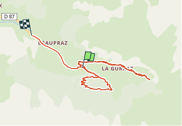
9.6 km | 20 km-effort
4h 32min
![](https://static1.geolcdn.com/siteimages/upload/files/16400158638029165_repeat_loop_refresh_sync_direction_icon.png)
No
![Trail Walking Peisey-Nancroix - Roselend- chapelle des Vernettes - Photo](https://media.geolcdn.com/t/375/260/caeb20d8-b45e-419b-83a2-db0814ea618a.jpg&format=jpg&maxdim=2)
![Walking Walking](https://static1.geolcdn.com/sitytour/trail-icons/101.png)
Roselend- chapelle des Vernettes
Walking
Easy
Peisey-Nancroix,
Auvergne-Rhône-Alpes,
Savoy,
France
![](/images/other/stat-length.png)
10.4 km | 16.6 km-effort
3h 18min
![](https://static1.geolcdn.com/siteimages/upload/files/16400158638029165_repeat_loop_refresh_sync_direction_icon.png)
Yes
![Trail Walking Peisey-Nancroix - la chapelle - Photo](https://media.geolcdn.com/t/375/260/7d1a0a4e-297d-405a-8b27-d2ee45329ab1.jpg&format=jpg&maxdim=2)
![Walking Walking](https://static1.geolcdn.com/sitytour/trail-icons/101.png)
la chapelle
Walking
Very easy
(1)
Peisey-Nancroix,
Auvergne-Rhône-Alpes,
Savoy,
France
![](/images/other/stat-length.png)
4.8 km | 7.3 km-effort
1h 34min
![](https://static1.geolcdn.com/siteimages/upload/files/16400158638029165_repeat_loop_refresh_sync_direction_icon.png)
Yes
![Trail Walking Peisey-Nancroix - Balade du Sanctuaire ND des Vernettes - Photo](https://media.geolcdn.com/t/375/260/ext.jpg?maxdim=2&url=https%3A%2F%2Fservices.sitytrail.com%2FGeolivesWS%2FDownloadMedia.ashx%3FTrailID%3D1033884%26Media%3D20180826152633.jpg)
![Walking Walking](https://static1.geolcdn.com/sitytour/trail-icons/101.png)
Balade du Sanctuaire ND des Vernettes
Walking
Medium
(1)
Peisey-Nancroix,
Auvergne-Rhône-Alpes,
Savoy,
France
![](/images/other/stat-length.png)
11.7 km | 21 km-effort
4h 11min
![](https://static1.geolcdn.com/siteimages/upload/files/16400158638029165_repeat_loop_refresh_sync_direction_icon.png)
Yes
![Trail Snowshoes Peisey-Nancroix - Autour de Rosuel - Photo](https://media.geolcdn.com/t/375/260/ext.jpg?maxdim=2&url=https%3A%2F%2Fservices.sitytrail.com%2FGeolivesWS%2FDownloadMedia.ashx%3FTrailID%3D913368%26Media%3Df405457e-81b0-40e6-865d-73d187d7b602.JPG)
![Snowshoes Snowshoes](https://static1.geolcdn.com/sitytour/trail-icons/504.png)
Autour de Rosuel
Snowshoes
Medium
Peisey-Nancroix,
Auvergne-Rhône-Alpes,
Savoy,
France
![](/images/other/stat-length.png)
6.1 km | 7.5 km-effort
2h 0min
![](https://static1.geolcdn.com/siteimages/upload/files/16400158638029165_repeat_loop_refresh_sync_direction_icon.png)
Yes
![Trail Snowshoes Peisey-Nancroix - Le sanctuaire des Vernettes - Photo](https://media.geolcdn.com/t/375/260/ext.jpg?maxdim=2&url=https%3A%2F%2Fservices.sitytrail.com%2FGeolivesWS%2FDownloadMedia.ashx%3FTrailID%3D912513%26Media%3Daf40344a-d6c9-4ee4-96b9-8f0082ef4938.JPG)
![Snowshoes Snowshoes](https://static1.geolcdn.com/sitytour/trail-icons/504.png)
Le sanctuaire des Vernettes
Snowshoes
Easy
Peisey-Nancroix,
Auvergne-Rhône-Alpes,
Savoy,
France
![](/images/other/stat-length.png)
5.8 km | 8.4 km-effort
2h 0min
![](https://static1.geolcdn.com/siteimages/upload/files/16400158638029165_repeat_loop_refresh_sync_direction_icon.png)
Yes
![Trail Walking Peisey-Nancroix - Cascades de Nant Putor et le Musée de la mine - Photo](https://media.geolcdn.com/t/375/260/f753e2f1-5225-42c2-adb9-332bc3fa30a8.jpg&format=jpg&maxdim=2)
![Walking Walking](https://static1.geolcdn.com/sitytour/trail-icons/101.png)
Cascades de Nant Putor et le Musée de la mine
Walking
Easy
Peisey-Nancroix,
Auvergne-Rhône-Alpes,
Savoy,
France
![](/images/other/stat-length.png)
10.6 km | 15.8 km-effort
5h 24min
![](https://static1.geolcdn.com/siteimages/upload/files/16400158638029165_repeat_loop_refresh_sync_direction_icon.png)
Yes
![Trail Walking Peisey-Nancroix - Peisey Vallandry Les Rossets Col d'Entreporte - Photo](https://media.geolcdn.com/t/375/260/13ebbf20-1090-4544-9f75-ac1ab2a608ef.jpg&format=jpg&maxdim=2)
![Walking Walking](https://static1.geolcdn.com/sitytour/trail-icons/101.png)
Peisey Vallandry Les Rossets Col d'Entreporte
Walking
Difficult
Peisey-Nancroix,
Auvergne-Rhône-Alpes,
Savoy,
France
![](/images/other/stat-length.png)
14.3 km | 26 km-effort
4h 51min
![](https://static1.geolcdn.com/siteimages/upload/files/16400158638029165_repeat_loop_refresh_sync_direction_icon.png)
Yes
![Trail Walking Peisey-Nancroix - Peisey Vallandry Les Charmettes Le Villaret - Photo](https://media.geolcdn.com/t/375/260/e9f0bda1-b82a-4265-849d-02e69427649f.jpg&format=jpg&maxdim=2)
![Walking Walking](https://static1.geolcdn.com/sitytour/trail-icons/101.png)
Peisey Vallandry Les Charmettes Le Villaret
Walking
Medium
Peisey-Nancroix,
Auvergne-Rhône-Alpes,
Savoy,
France
![](/images/other/stat-length.png)
6.3 km | 8.6 km-effort
1h 47min
![](https://static1.geolcdn.com/siteimages/upload/files/16400158638029165_repeat_loop_refresh_sync_direction_icon.png)
No