![](/images/other/stat-length.png)
![Trail Walking Concarneau - Concarneau_2020 - Photo](https://media.geolcdn.com/t/1900/400/ext.pjpeg?maxdim=2&url=https%3A%2F%2Fstatic1.geolcdn.com%2Fsiteimages%2Fupload%2Ffiles%2F1553511878bg_sport_marche.png)
Concarneau_2020
gmarchas
User
![Length](/images/other/stat-length.png)
Length
19.4 km
![Max alt](https://static1.geolcdn.com/siteimages/upload/files/1508320355ic_sort_altitude_max_24dp.png)
Max alt
29 m
![Uphill gradient](https://static1.geolcdn.com/siteimages/upload/files/1508320355ic_sort_den_pos_24dp.png)
Uphill gradient
201 m
![Km-Effort](/images/other/stat-length.png)
Km-Effort
22 km
![Min alt](https://static1.geolcdn.com/siteimages/upload/files/1508320355ic_sort_altitude_min_24dp.png)
Min alt
-2 m
![Downhill gradient](https://static1.geolcdn.com/siteimages/upload/files/1508320355ic_sort_den_neg_24dp.png)
Downhill gradient
201 m
![Boucle](https://static1.geolcdn.com/siteimages/upload/files/16400158638029165_repeat_loop_refresh_sync_direction_icon.png)
Boucle
Yes
Creation date :
2020-05-23 11:14:32.673
Updated on :
2020-05-23 19:21:09.313
![Walking](https://static1.geolcdn.com/sitytour/trail-icons/101.png)
4h02
Difficulty : Easy
![Scan this QR Code to open this trail in the SityTrail application](https://capi.geolives.com/qq0zvz2zws4bq2lad0pu/sitytour/trails/2407989/qr.png?size=200)
FREE GPS app for hiking
About
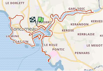
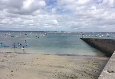
Trail Walking of 19.4 km to be discovered at Brittany, Finistère, Concarneau. This trail is proposed by gmarchas.
Description
19,6km 3D mais 600m avec le bac car celui-ci a été dévié vers l'office du tourisme qui est fermé. Et ceci pour déjouer les plans du virus. Sont-ils malins !
Positioning
Country:
France
Region :
Brittany
Department/Province :
Finistère
Municipality :
Concarneau
Location:
Unknown
Start:(Dec)
Start:(UTM)
431622 ; 5303004 (30T) N.
Comments
Trails nearby
![Trail Running Trégunc - GR34 - 31 - Photo](https://media.geolcdn.com/t/375/260/ext.jpg?maxdim=2&url=https%3A%2F%2Fstatic1.geolcdn.com%2Fsiteimages%2Fupload%2Ffiles%2F1524743154running.jpg)
![Running Running](https://static1.geolcdn.com/sitytour/trail-icons/103.png)
![Trail Walking Trégunc - Yregunc re ar wenodenn - Photo](https://media.geolcdn.com/t/375/260/920b2546-d768-4de0-82fe-cbd6fddcfc28.jpg&format=jpg&maxdim=2)
![Walking Walking](https://static1.geolcdn.com/sitytour/trail-icons/101.png)
Yregunc re ar wenodenn
Walking
Easy
Trégunc,
Brittany,
Finistère,
France
![](/images/other/stat-length.png)
5.8 km | 6.2 km-effort
1h 33min
![](https://static1.geolcdn.com/siteimages/upload/files/16400158638029165_repeat_loop_refresh_sync_direction_icon.png)
Yes
![Trail Walking Concarneau - Concarneau - Photo](https://media.geolcdn.com/t/375/260/2444e120-f150-4c71-a608-b49e9d318714.jpg&format=jpg&maxdim=2)
![Walking Walking](https://static1.geolcdn.com/sitytour/trail-icons/101.png)
![Trail Running Fouesnant - Des dunes à la mer blanche - Photo](https://media.geolcdn.com/t/375/260/7fdce5c7-5ee5-431b-bdc0-c7bba51fc745.jpg&format=jpg&maxdim=2)
![Running Running](https://static1.geolcdn.com/sitytour/trail-icons/103.png)
Des dunes à la mer blanche
Running
Very easy
Fouesnant,
Brittany,
Finistère,
France
![](/images/other/stat-length.png)
18.8 km | 19.8 km-effort
2h 18min
![](https://static1.geolcdn.com/siteimages/upload/files/16400158638029165_repeat_loop_refresh_sync_direction_icon.png)
Yes
![Trail Walking Trégunc - Tregunc - Photo](https://media.geolcdn.com/t/375/260/0294ed77-693d-4112-8e2e-97085a77d8cd.jpg&format=jpg&maxdim=2)
![Walking Walking](https://static1.geolcdn.com/sitytour/trail-icons/101.png)
![Trail On foot Concarneau - Sentier Côtier du Moros - Photo](https://media.geolcdn.com/t/375/260/370a1ef6-acb4-40b8-b86a-15fe25cfb993.jpeg&format=jpg&maxdim=2)
![On foot On foot](https://static1.geolcdn.com/sitytour/trail-icons/100.png)
Sentier Côtier du Moros
On foot
Easy
Concarneau,
Brittany,
Finistère,
France
![](/images/other/stat-length.png)
5 km | 6.1 km-effort
1h 22min
![](https://static1.geolcdn.com/siteimages/upload/files/16400158638029165_repeat_loop_refresh_sync_direction_icon.png)
Yes
![Trail Walking Concarneau - Concarneau - Photo](https://media.geolcdn.com/t/375/260/c8e14188-59e6-45fc-97a1-567ba3c5a7c1.jpg&format=jpg&maxdim=2)
![Walking Walking](https://static1.geolcdn.com/sitytour/trail-icons/101.png)
![Trail Walking Concarneau - Beg Meil kerambigorn -Concarneau - Photo](https://media.geolcdn.com/t/375/260/ext.jpg?maxdim=2&url=https%3A%2F%2Fservices.sitytrail.com%2FGeolivesWS%2FDownloadMedia.ashx%3FTrailID%3D797152%26Media%3D20170727154145.jpg)
![Walking Walking](https://static1.geolcdn.com/sitytour/trail-icons/101.png)
Beg Meil kerambigorn -Concarneau
Walking
Easy
Concarneau,
Brittany,
Finistère,
France
![](/images/other/stat-length.png)
23 km | 26 km-effort
4h 49min
![](https://static1.geolcdn.com/siteimages/upload/files/16400158638029165_repeat_loop_refresh_sync_direction_icon.png)
No
![Trail Walking Concarneau - 29-1-Concarneau Est - Photo](https://media.geolcdn.com/t/375/260/ext.jpg?maxdim=2&url=https%3A%2F%2Fstatic1.geolcdn.com%2Fsiteimages%2Fupload%2Ffiles%2F1553511878bg_sport_marche.png)
![Walking Walking](https://static1.geolcdn.com/sitytour/trail-icons/101.png)
29-1-Concarneau Est
Walking
Easy
(1)
Concarneau,
Brittany,
Finistère,
France
![](/images/other/stat-length.png)
12.4 km | 13.7 km-effort
3h 30min
![](https://static1.geolcdn.com/siteimages/upload/files/16400158638029165_repeat_loop_refresh_sync_direction_icon.png)
Yes