![](/images/other/stat-length.png)
![Trail Walking Risoul - Risoul 1850 Le Villaret - Photo](https://media.geolcdn.com/t/1900/400/ext.pjpeg?maxdim=2&url=https%3A%2F%2Fmedia.geolcdn.com%2Ff%2F67eefd3f-ef26-46c7-8d59-a559de4cf6c9.jpg)
Risoul 1850 Le Villaret
Sorriaux
User
![Length](/images/other/stat-length.png)
Length
12.3 km
![Max alt](https://static1.geolcdn.com/siteimages/upload/files/1508320355ic_sort_altitude_max_24dp.png)
Max alt
2044 m
![Uphill gradient](https://static1.geolcdn.com/siteimages/upload/files/1508320355ic_sort_den_pos_24dp.png)
Uphill gradient
224 m
![Km-Effort](/images/other/stat-length.png)
Km-Effort
18.1 km
![Min alt](https://static1.geolcdn.com/siteimages/upload/files/1508320355ic_sort_altitude_min_24dp.png)
Min alt
1035 m
![Downhill gradient](https://static1.geolcdn.com/siteimages/upload/files/1508320355ic_sort_den_neg_24dp.png)
Downhill gradient
1066 m
![Boucle](https://static1.geolcdn.com/siteimages/upload/files/16400158638029165_repeat_loop_refresh_sync_direction_icon.png)
Boucle
No
Creation date :
2020-05-20 07:42:36.328
Updated on :
2020-05-20 13:32:10.088
![Walking](https://static1.geolcdn.com/sitytour/trail-icons/101.png)
4h00
Difficulty : Medium
![Scan this QR Code to open this trail in the SityTrail application](https://capi.geolives.com/qq0zvz2zws4bq2lad0pu/sitytour/trails/2402808/qr.png?size=200)
FREE GPS app for hiking
About
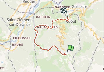
Trail Walking of 12.3 km to be discovered at Provence-Alpes-Côte d'Azur, Hautes-Alpes, Risoul. This trail is proposed by Sorriaux.
Description
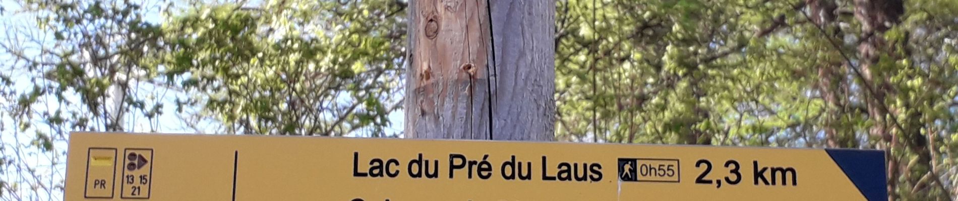
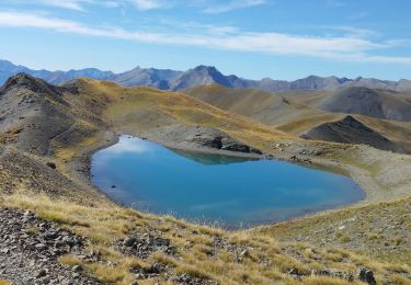
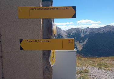
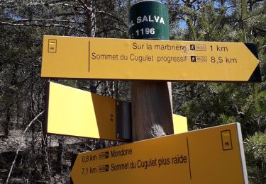
Lac du pre du laus, crête de Martinet, bois de Barbein, torrent de Salvet. Moyen dans le sens descendant, difficile dans le sens de la montée
Positioning
Country:
France
Region :
Provence-Alpes-Côte d'Azur
Department/Province :
Hautes-Alpes
Municipality :
Risoul
Location:
Unknown
Start:(Dec)
Start:(UTM)
312305 ; 4943583 (32T) N.
Comments
Trails nearby
![Trail Walking Guillestre - guillestre, rif bel,col de la scie, crete de vars,la coulette et retour par riou bel - Photo](https://media.geolcdn.com/t/375/260/ext.jpg?maxdim=2&url=https%3A%2F%2Fmedia.geolcdn.com%2Ff%2F54d13cf2-4d94-4565-98e3-f843a6841792.jpeg)
![Walking Walking](https://static1.geolcdn.com/sitytour/trail-icons/101.png)
guillestre, rif bel,col de la scie, crete de vars,la coulette et retour par r...
Walking
Very difficult
Guillestre,
Provence-Alpes-Côte d'Azur,
Hautes-Alpes,
France
![](/images/other/stat-length.png)
24 km | 45 km-effort
6h 24min
![](https://static1.geolcdn.com/siteimages/upload/files/16400158638029165_repeat_loop_refresh_sync_direction_icon.png)
Yes
![Trail Mountain bike Vars - lac de peyrol ,col de vars,crête de la maït,retour ST marcellin - Photo](https://media.geolcdn.com/t/375/260/ext.jpg?maxdim=2&url=https%3A%2F%2Fmedia.geolcdn.com%2Ff%2Fb4233dcf-6dc5-431e-a774-5dd68562ea78.jpeg)
![Mountain bike Mountain bike](https://static1.geolcdn.com/sitytour/trail-icons/202.png)
lac de peyrol ,col de vars,crête de la maït,retour ST marcellin
Mountain bike
Very difficult
Vars,
Provence-Alpes-Côte d'Azur,
Hautes-Alpes,
France
![](/images/other/stat-length.png)
32 km | 47 km-effort
3h 29min
![](https://static1.geolcdn.com/siteimages/upload/files/16400158638029165_repeat_loop_refresh_sync_direction_icon.png)
Yes
![Trail Walking Saint-André-d'Embrun - Chapelle de Pra-Leydon - Les Croix à partir du vallon de Pra-Mouton - Photo](https://media.geolcdn.com/t/375/260/ext.jpg?maxdim=2&url=https%3A%2F%2Fmedia.geolcdn.com%2Ff%2Faacec509-0b58-4c91-85a8-3755e48f0d89.jpg)
![Walking Walking](https://static1.geolcdn.com/sitytour/trail-icons/101.png)
Chapelle de Pra-Leydon - Les Croix à partir du vallon de Pra-Mouton
Walking
Very difficult
Saint-André-d'Embrun,
Provence-Alpes-Côte d'Azur,
Hautes-Alpes,
France
![](/images/other/stat-length.png)
6.8 km | 15.3 km-effort
3h 45min
![](https://static1.geolcdn.com/siteimages/upload/files/16400158638029165_repeat_loop_refresh_sync_direction_icon.png)
Yes
![Trail Walking Vars - Pic de Chabrières 2744m 31.7.22 - Photo](https://media.geolcdn.com/t/375/260/ext.jpg?maxdim=2&url=https%3A%2F%2Fmedia.geolcdn.com%2Ff%2F27b448de-709d-4eac-ac4d-b3bdd6c8e895.jpg)
![Walking Walking](https://static1.geolcdn.com/sitytour/trail-icons/101.png)
Pic de Chabrières 2744m 31.7.22
Walking
Difficult
Vars,
Provence-Alpes-Côte d'Azur,
Hautes-Alpes,
France
![](/images/other/stat-length.png)
9.7 km | 15.9 km-effort
3h 25min
![](https://static1.geolcdn.com/siteimages/upload/files/16400158638029165_repeat_loop_refresh_sync_direction_icon.png)
No
![Trail Walking Risoul - plan de phazy par la forêt de risoul en boucle - Photo](https://media.geolcdn.com/t/375/260/ext.jpg?maxdim=2&url=https%3A%2F%2Fmedia.geolcdn.com%2Ff%2Fc28620ac-cba0-40fe-a63d-d7c910dcbe1a.jpg)
![Walking Walking](https://static1.geolcdn.com/sitytour/trail-icons/101.png)
plan de phazy par la forêt de risoul en boucle
Walking
Difficult
Risoul,
Provence-Alpes-Côte d'Azur,
Hautes-Alpes,
France
![](/images/other/stat-length.png)
17.5 km | 34 km-effort
4h 38min
![](https://static1.geolcdn.com/siteimages/upload/files/16400158638029165_repeat_loop_refresh_sync_direction_icon.png)
Yes
![Trail Walking Guillestre - cugulet aller retour - Photo](https://media.geolcdn.com/t/375/260/ext.jpg?maxdim=2&url=https%3A%2F%2Fmedia.geolcdn.com%2Ff%2F6b6903a0-4e39-47ac-9b05-0cd4223cf15b.jpg)
![Walking Walking](https://static1.geolcdn.com/sitytour/trail-icons/101.png)
cugulet aller retour
Walking
Medium
Guillestre,
Provence-Alpes-Côte d'Azur,
Hautes-Alpes,
France
![](/images/other/stat-length.png)
14.6 km | 33 km-effort
4h 2min
![](https://static1.geolcdn.com/siteimages/upload/files/16400158638029165_repeat_loop_refresh_sync_direction_icon.png)
Yes
![Trail Walking Guillestre - Roche Rousse et Rocher de l'aigle à Guillestre - Photo](https://media.geolcdn.com/t/375/260/ext.jpg?maxdim=2&url=https%3A%2F%2Fmedia.geolcdn.com%2Ff%2Fef83071a-a3e5-4323-a0d2-2f834a181802.jpg)
![Walking Walking](https://static1.geolcdn.com/sitytour/trail-icons/101.png)
Roche Rousse et Rocher de l'aigle à Guillestre
Walking
Medium
Guillestre,
Provence-Alpes-Côte d'Azur,
Hautes-Alpes,
France
![](/images/other/stat-length.png)
8.6 km | 14 km-effort
2h 52min
![](https://static1.geolcdn.com/siteimages/upload/files/16400158638029165_repeat_loop_refresh_sync_direction_icon.png)
Yes
![Trail Walking Risoul - Crêtes de Penon - Photo](https://media.geolcdn.com/t/375/260/ext.jpg?maxdim=2&url=https%3A%2F%2Fmedia.geolcdn.com%2Ff%2F14f96927-0740-4f05-9cfe-ba43580669a7.jpg)
![Walking Walking](https://static1.geolcdn.com/sitytour/trail-icons/101.png)
Crêtes de Penon
Walking
Very easy
(1)
Risoul,
Provence-Alpes-Côte d'Azur,
Hautes-Alpes,
France
![](/images/other/stat-length.png)
10.6 km | 15.3 km-effort
3h 15min
![](https://static1.geolcdn.com/siteimages/upload/files/16400158638029165_repeat_loop_refresh_sync_direction_icon.png)
Yes
![Trail Walking Risoul - Le Villaret plan Phazy - Photo](https://media.geolcdn.com/t/375/260/ext.jpg?maxdim=2&url=https%3A%2F%2Fmedia.geolcdn.com%2Ff%2Fcf32f774-53da-40e4-b349-6bec0523a9a8.jpg)
![Walking Walking](https://static1.geolcdn.com/sitytour/trail-icons/101.png)
Le Villaret plan Phazy
Walking
Medium
Risoul,
Provence-Alpes-Côte d'Azur,
Hautes-Alpes,
France
![](/images/other/stat-length.png)
10.9 km | 16.5 km-effort
3h 11min
![](https://static1.geolcdn.com/siteimages/upload/files/16400158638029165_repeat_loop_refresh_sync_direction_icon.png)
Yes