![](/images/other/stat-length.png)
![Trail Walking Saint-Gervazy - St_Gervazy_Les_Chaux - Photo](https://media.geolcdn.com/t/1900/400/e0a88799-2f1c-49aa-9e90-83ffbccbf3c9.jpg&format=pjpeg&maxdim=2)
St_Gervazy_Les_Chaux
jagarnier
User GUIDE
![Length](/images/other/stat-length.png)
Length
14.3 km
![Max alt](https://static1.geolcdn.com/siteimages/upload/files/1508320355ic_sort_altitude_max_24dp.png)
Max alt
739 m
![Uphill gradient](https://static1.geolcdn.com/siteimages/upload/files/1508320355ic_sort_den_pos_24dp.png)
Uphill gradient
291 m
![Km-Effort](/images/other/stat-length.png)
Km-Effort
18.2 km
![Min alt](https://static1.geolcdn.com/siteimages/upload/files/1508320355ic_sort_altitude_min_24dp.png)
Min alt
495 m
![Downhill gradient](https://static1.geolcdn.com/siteimages/upload/files/1508320355ic_sort_den_neg_24dp.png)
Downhill gradient
291 m
![Boucle](https://static1.geolcdn.com/siteimages/upload/files/16400158638029165_repeat_loop_refresh_sync_direction_icon.png)
Boucle
Yes
Creation date :
2020-05-19 15:56:11.118
Updated on :
2022-07-24 11:25:12.814
![Walking](https://static1.geolcdn.com/sitytour/trail-icons/101.png)
4h15
Difficulty : Medium
![Scan this QR Code to open this trail in the SityTrail application](https://capi.geolives.com/qq0zvz2zws4bq2lad0pu/sitytour/trails/2401920/qr.png?size=200)
FREE GPS app for hiking
About
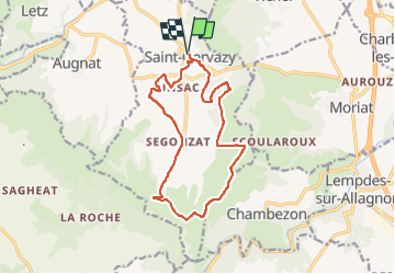
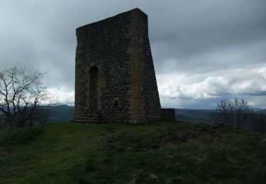
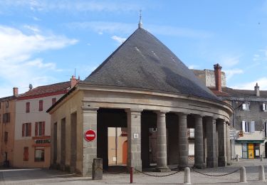
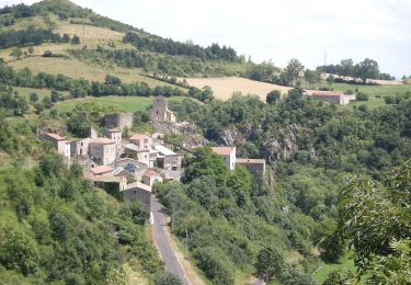
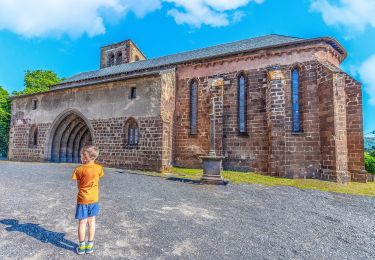
Trail Walking of 14.3 km to be discovered at Auvergne-Rhône-Alpes, Puy-de-Dôme, Saint-Gervazy. This trail is proposed by jagarnier.
Description
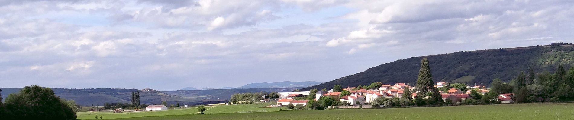
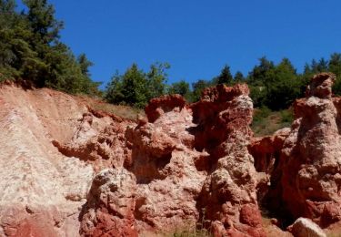
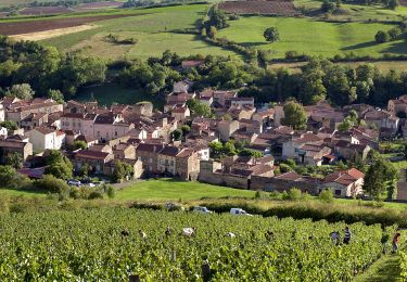
Saint-Gervazy, village à la pierre blonde ne manque pas de charme avec son château et son église abritant une vierge noire. Le sentier monte sur les chaux de calcaire formant un vaste promontoire avec vue imprenable sur le Livradois-Forez et le Cézallier.
Positioning
Country:
France
Region :
Auvergne-Rhône-Alpes
Department/Province :
Puy-de-Dôme
Municipality :
Saint-Gervazy
Location:
Unknown
Start:(Dec)
Start:(UTM)
516904 ; 5029104 (31T) N.
Comments
Trails nearby
![Trail Walking Boudes - Boudes_Cheminees_Fees - Photo](https://media.geolcdn.com/t/375/260/2d6f9b52-9afa-4443-acb4-142ca3c3881a.jpg&format=jpg&maxdim=2)
![Walking Walking](https://static1.geolcdn.com/sitytour/trail-icons/101.png)
Boudes_Cheminees_Fees
Walking
Easy
(1)
Boudes,
Auvergne-Rhône-Alpes,
Puy-de-Dôme,
France
![](/images/other/stat-length.png)
5.9 km | 8.2 km-effort
1h 45min
![](https://static1.geolcdn.com/siteimages/upload/files/16400158638029165_repeat_loop_refresh_sync_direction_icon.png)
Yes
![Trail Walking Boudes - Boudes_Vallee_Saints - Photo](https://media.geolcdn.com/t/375/260/75dcab49-0943-405f-9b02-ddf9cf506eea.jpg&format=jpg&maxdim=2)
![Walking Walking](https://static1.geolcdn.com/sitytour/trail-icons/101.png)
Boudes_Vallee_Saints
Walking
Medium
(1)
Boudes,
Auvergne-Rhône-Alpes,
Puy-de-Dôme,
France
![](/images/other/stat-length.png)
10.9 km | 15.1 km-effort
3h 15min
![](https://static1.geolcdn.com/siteimages/upload/files/16400158638029165_repeat_loop_refresh_sync_direction_icon.png)
Yes
![Trail Walking Boudes - Boudes_Coteaux - Photo](https://media.geolcdn.com/t/375/260/84417786-618e-40d7-80a8-c68612090218.jpg&format=jpg&maxdim=2)
![Walking Walking](https://static1.geolcdn.com/sitytour/trail-icons/101.png)
Boudes_Coteaux
Walking
Medium
(1)
Boudes,
Auvergne-Rhône-Alpes,
Puy-de-Dôme,
France
![](/images/other/stat-length.png)
11.1 km | 14.8 km-effort
3h 15min
![](https://static1.geolcdn.com/siteimages/upload/files/16400158638029165_repeat_loop_refresh_sync_direction_icon.png)
Yes
![Trail Walking Vichel - Saint Gervazy - Photo](https://media.geolcdn.com/t/375/260/ext.jpg?maxdim=2&url=https%3A%2F%2Fservices.sitytrail.com%2FGeolivesWS%2FDownloadMedia.ashx%3FTrailID%3D103263%26Media%3D5216_2.jpg)
![Walking Walking](https://static1.geolcdn.com/sitytour/trail-icons/101.png)
Saint Gervazy
Walking
Difficult
(1)
Vichel,
Auvergne-Rhône-Alpes,
Puy-de-Dôme,
France
![](/images/other/stat-length.png)
10.3 km | 14.8 km-effort
3h 0min
![](https://static1.geolcdn.com/siteimages/upload/files/16400158638029165_repeat_loop_refresh_sync_direction_icon.png)
Yes
![Trail On foot Lempdes-sur-Allagnon - Les Cotes de Lempdes - Photo](https://media.geolcdn.com/t/375/260/042ee3cd-d37d-4ebc-8664-1e976fdcf510.jpeg&format=jpg&maxdim=2)
![On foot On foot](https://static1.geolcdn.com/sitytour/trail-icons/100.png)
Les Cotes de Lempdes
On foot
Easy
Lempdes-sur-Allagnon,
Auvergne-Rhône-Alpes,
Haute-Loire,
France
![](/images/other/stat-length.png)
9 km | 11.6 km-effort
2h 37min
![](https://static1.geolcdn.com/siteimages/upload/files/16400158638029165_repeat_loop_refresh_sync_direction_icon.png)
Yes
![Trail On foot Madriat - Bard et Letz - Photo](https://media.geolcdn.com/t/375/260/e7b4e9aa-8c72-4cfb-b241-a0f535763702.jpeg&format=jpg&maxdim=2)
![On foot On foot](https://static1.geolcdn.com/sitytour/trail-icons/100.png)
Bard et Letz
On foot
Easy
Madriat,
Auvergne-Rhône-Alpes,
Puy-de-Dôme,
France
![](/images/other/stat-length.png)
9.9 km | 13.3 km-effort
3h 1min
![](https://static1.geolcdn.com/siteimages/upload/files/16400158638029165_repeat_loop_refresh_sync_direction_icon.png)
Yes
![Trail On foot Boudes - La Vallee des Saints - Photo](https://media.geolcdn.com/t/375/260/8b5212f5-c0d3-403b-b77d-cbcbaaa74e95.jpeg&format=jpg&maxdim=2)
![On foot On foot](https://static1.geolcdn.com/sitytour/trail-icons/100.png)
La Vallee des Saints
On foot
Easy
(1)
Boudes,
Auvergne-Rhône-Alpes,
Puy-de-Dôme,
France
![](/images/other/stat-length.png)
8.1 km | 11.1 km-effort
2h 31min
![](https://static1.geolcdn.com/siteimages/upload/files/16400158638029165_repeat_loop_refresh_sync_direction_icon.png)
Yes
![Trail On foot Apchat - La Chaux de Caure - Photo](https://media.geolcdn.com/t/375/260/56d74c0a-47b8-44fb-8594-945b1d52b539.jpeg&format=jpg&maxdim=2)
![On foot On foot](https://static1.geolcdn.com/sitytour/trail-icons/100.png)
La Chaux de Caure
On foot
Easy
Apchat,
Auvergne-Rhône-Alpes,
Puy-de-Dôme,
France
![](/images/other/stat-length.png)
11.6 km | 15.8 km-effort
3h 35min
![](https://static1.geolcdn.com/siteimages/upload/files/16400158638029165_repeat_loop_refresh_sync_direction_icon.png)
Yes
![Trail Walking Saint-Germain-Lembron - Entre béal et pigeonniers - Saint Germain Lembron - Photo](https://media.geolcdn.com/t/375/260/ext.jpg?maxdim=2&url=https%3A%2F%2Fstatic1.geolcdn.com%2Fsiteimages%2Fupload%2Ffiles%2F1553511878bg_sport_marche.png)
![Walking Walking](https://static1.geolcdn.com/sitytour/trail-icons/101.png)
Entre béal et pigeonniers - Saint Germain Lembron
Walking
Medium
(1)
Saint-Germain-Lembron,
Auvergne-Rhône-Alpes,
Puy-de-Dôme,
France
![](/images/other/stat-length.png)
9.8 km | 11.1 km-effort
2h 30min
![](https://static1.geolcdn.com/siteimages/upload/files/16400158638029165_repeat_loop_refresh_sync_direction_icon.png)
Yes