![](/images/other/stat-length.png)
![Trail Other activity Val-de-Travers - VB Tablettes Noiraiges - Photo](https://media.geolcdn.com/t/1900/400/ext.pjpeg?maxdim=2&url=https%3A%2F%2Fstatic1.geolcdn.com%2Fsiteimages%2Fupload%2Ffiles%2F1545311037marcheuse_200dpi.jpg)
VB Tablettes Noiraiges
hrb
User
![Length](/images/other/stat-length.png)
Length
13.8 km
![Max alt](https://static1.geolcdn.com/siteimages/upload/files/1508320355ic_sort_altitude_max_24dp.png)
Max alt
1284 m
![Uphill gradient](https://static1.geolcdn.com/siteimages/upload/files/1508320355ic_sort_den_pos_24dp.png)
Uphill gradient
663 m
![Km-Effort](/images/other/stat-length.png)
Km-Effort
23 km
![Min alt](https://static1.geolcdn.com/siteimages/upload/files/1508320355ic_sort_altitude_min_24dp.png)
Min alt
539 m
![Downhill gradient](https://static1.geolcdn.com/siteimages/upload/files/1508320355ic_sort_den_neg_24dp.png)
Downhill gradient
847 m
![Boucle](https://static1.geolcdn.com/siteimages/upload/files/16400158638029165_repeat_loop_refresh_sync_direction_icon.png)
Boucle
No
Creation date :
2014-12-11 00:00:00.0
Updated on :
2014-12-11 00:00:00.0
![Other activity](https://static1.geolcdn.com/sitytour/trail-icons/900.png)
--
Difficulty : Unknown
![Scan this QR Code to open this trail in the SityTrail application](https://capi.geolives.com/qq0zvz2zws4bq2lad0pu/sitytour/trails/23967/qr.png?size=200)
FREE GPS app for hiking
About
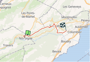
Trail Other activity of 13.8 km to be discovered at Neuchâtel, Unknown, Val-de-Travers. This trail is proposed by hrb.
Description
Ursprünglich war die Wanderung länger, aber die Wege entlang der Menthue waren saumässig verwildert!
Achtung: die Brücke bei Bois Dessous existierte am 2.05.2008 nicht mehr.
Positioning
Country:
Switzerland
Region :
Neuchâtel
Department/Province :
Unknown
Municipality :
Val-de-Travers
Location:
Unknown
Start:(Dec)
Start:(UTM)
326684 ; 5202666 (32T) N.
Comments
Trails nearby
![Trail On foot Val-de-Travers - Ferme du Soliat - La Banderette - Photo](https://media.geolcdn.com/t/375/260/592b5f1a-c4f5-43de-8e09-4f7fd6995df5.jpeg&format=jpg&maxdim=2)
![On foot On foot](https://static1.geolcdn.com/sitytour/trail-icons/100.png)
Ferme du Soliat - La Banderette
On foot
Easy
Val-de-Travers,
Neuchâtel,
Unknown,
Switzerland
![](/images/other/stat-length.png)
3.8 km | 7 km-effort
1h 35min
![](https://static1.geolcdn.com/siteimages/upload/files/16400158638029165_repeat_loop_refresh_sync_direction_icon.png)
No
![Trail On foot Val-de-Travers - Les Oeuillons-Le Soliat - Photo](https://media.geolcdn.com/t/375/260/d6dbfe3d-16a5-4a11-88ea-3fe674f56dd4.jpeg&format=jpg&maxdim=2)
![On foot On foot](https://static1.geolcdn.com/sitytour/trail-icons/100.png)
Les Oeuillons-Le Soliat
On foot
Easy
Val-de-Travers,
Neuchâtel,
Unknown,
Switzerland
![](/images/other/stat-length.png)
3 km | 7.3 km-effort
1h 39min
![](https://static1.geolcdn.com/siteimages/upload/files/16400158638029165_repeat_loop_refresh_sync_direction_icon.png)
No
![Trail Walking Val-de-Travers - Creux du Van Noiraigue (Suisse) 13.2km - Photo](https://media.geolcdn.com/t/375/260/ext.jpg?maxdim=2&url=https%3A%2F%2Fstatic1.geolcdn.com%2Fsiteimages%2Fupload%2Ffiles%2F1553511878bg_sport_marche.png)
![Walking Walking](https://static1.geolcdn.com/sitytour/trail-icons/101.png)
Creux du Van Noiraigue (Suisse) 13.2km
Walking
Difficult
(1)
Val-de-Travers,
Neuchâtel,
Unknown,
Switzerland
![](/images/other/stat-length.png)
13.2 km | 23 km-effort
3h 20min
![](https://static1.geolcdn.com/siteimages/upload/files/16400158638029165_repeat_loop_refresh_sync_direction_icon.png)
Yes
![Trail Other activity Val-de-Travers - Gorges de l''Areuse - Photo](https://media.geolcdn.com/t/375/260/ext.jpg?maxdim=2&url=https%3A%2F%2Fstatic1.geolcdn.com%2Fsiteimages%2Fupload%2Ffiles%2F1545311037marcheuse_200dpi.jpg)
![Other activity Other activity](https://static1.geolcdn.com/sitytour/trail-icons/900.png)
Gorges de l''Areuse
Other activity
Very easy
(1)
Val-de-Travers,
Neuchâtel,
Unknown,
Switzerland
![](/images/other/stat-length.png)
11.2 km | 14.1 km-effort
Unknown
![](https://static1.geolcdn.com/siteimages/upload/files/16400158638029165_repeat_loop_refresh_sync_direction_icon.png)
No
![Trail On foot Val-de-Travers - Noiraigue - Travers? - fixme - Photo](https://media.geolcdn.com/t/375/260/e50c19fd-e8f6-4615-bf26-22c1a6fca7f1.jpeg&format=jpg&maxdim=2)
![On foot On foot](https://static1.geolcdn.com/sitytour/trail-icons/100.png)
Noiraigue - Travers? - fixme
On foot
Easy
Val-de-Travers,
Neuchâtel,
Unknown,
Switzerland
![](/images/other/stat-length.png)
5.6 km | 6.6 km-effort
1h 30min
![](https://static1.geolcdn.com/siteimages/upload/files/16400158638029165_repeat_loop_refresh_sync_direction_icon.png)
No
![Trail Walking Val-de-Travers - Gorges de l'Areuse, Creux du Van - Photo](https://media.geolcdn.com/t/375/260/ext.jpg?maxdim=2&url=https%3A%2F%2Fservices.sitytrail.com%2FGeolivesWS%2FDownloadMedia.ashx%3FTrailID%3D635692%26Media%3Dfix__20160924113824.jpg)
![Walking Walking](https://static1.geolcdn.com/sitytour/trail-icons/101.png)
Gorges de l'Areuse, Creux du Van
Walking
Difficult
Val-de-Travers,
Neuchâtel,
Unknown,
Switzerland
![](/images/other/stat-length.png)
17.3 km | 30 km-effort
5h 19min
![](https://static1.geolcdn.com/siteimages/upload/files/16400158638029165_repeat_loop_refresh_sync_direction_icon.png)
Yes
![Trail Walking Val-de-Travers - Jour trois Jura - Photo](https://media.geolcdn.com/t/375/260/3138e73a-067b-49d6-a001-5fdda0d138a5.jpg&format=jpg&maxdim=2)
![Walking Walking](https://static1.geolcdn.com/sitytour/trail-icons/101.png)
Jour trois Jura
Walking
Medium
Val-de-Travers,
Neuchâtel,
Unknown,
Switzerland
![](/images/other/stat-length.png)
16.1 km | 27 km-effort
7h 52min
![](https://static1.geolcdn.com/siteimages/upload/files/16400158638029165_repeat_loop_refresh_sync_direction_icon.png)
No
![Trail Trail Provence - Creux des van - Photo](https://media.geolcdn.com/t/375/260/c9b8247a-118d-467b-8152-6c2f1ae5b769.jpg&format=jpg&maxdim=2)
![Trail Trail](https://static1.geolcdn.com/sitytour/trail-icons/104.png)
Creux des van
Trail
Easy
Provence,
Vaud,
District du Jura-Nord vaudois,
Switzerland
![](/images/other/stat-length.png)
57 km | 72 km-effort
3h 30min
![](https://static1.geolcdn.com/siteimages/upload/files/16400158638029165_repeat_loop_refresh_sync_direction_icon.png)
No
![Trail Walking Val-de-Travers - Creux du Van 1 mai 2019 CKCC - Photo](https://media.geolcdn.com/t/375/260/03cd3c1f-6bce-408c-aefa-acc6e10be2c0.jpg&format=jpg&maxdim=2)
![Walking Walking](https://static1.geolcdn.com/sitytour/trail-icons/101.png)
Creux du Van 1 mai 2019 CKCC
Walking
Very easy
Val-de-Travers,
Neuchâtel,
Unknown,
Switzerland
![](/images/other/stat-length.png)
13.4 km | 24 km-effort
7h 5min
![](https://static1.geolcdn.com/siteimages/upload/files/16400158638029165_repeat_loop_refresh_sync_direction_icon.png)
Yes