


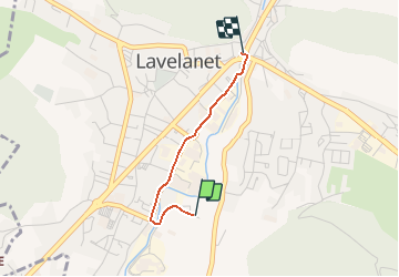

12.6 km | 21 km-effort


User


FREE GPS app for hiking
 SityTrail
IGN / Geographical institutes
SityTrail World
The world is yours!
Trail On foot of 1.7 km to be discovered at Occitania, Ariège, Lavelanet. This trail is proposed by jopost.
4ème parcours depuis le Village des BonsHommes vers le centre-ville.
a pied, en vélo ou en voiture, après le pont, prenez à droite la rue Jacquard jusqu'au bout puis encore à droite vers la rue Quille, longez le Touyre , vous arrivez au rond-point.

Walking
Electric bike
Walking

On foot

Walking
Walking

Walking

Walking

Walking