


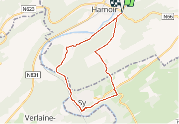

22 km | 28 km-effort

User


FREE GPS app for hiking
 SityTrail
IGN / Geographical institutes
SityTrail World
The world is yours!
Trail Walking of 7.3 km to be discovered at Wallonia, Liège, Hamoir. This trail is proposed by chrlouette.
Attention traversée de prairies avec vaches et taureaux. Promenade très variée, mais avec descente périlleuse sur Sy et les deux derniers kilomètres sur asphalte.


Walking

Walking

Walking

Walking

Walking

Walking
Walking
Walking

Walking