Trail Other activity Buus - BL Buseregg - Zuzgen - Mumpf - Photo

BL Buseregg - Zuzgen - Mumpf

 hrb
hrb

User

© OpenStreetMap contributors
Length
Length
11.4 km
Max alt
Max alt
666 m
Uphill gradient
Uphill gradient
392 m
Km-Effort
Km-Effort  
17.5 km
Min alt
Min alt
315 m
Downhill gradient
Downhill gradient
652 m
Boucle
Boucle
No
Creation date :
2014-12-11 00:00:00.0
Updated on :
2014-12-11 00:00:00.0

(0 Reviews)

Other activity
Other activity
--
Difficulty : Unknown

Scan this QR Code to open this trail in the SityTrail application

FREE GPS app for hiking

Logo SityTrail SityTrail

IGN / Geographical institutes

Download SityTrail from the App Store Download SityTrail from Google Play

Logo SityTrail SityTrail World

The world is yours!

Download SityTrail from the App Store Download SityTrail from Google Play Download SityTrail on Huawei AppGallery

About

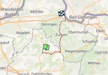
Trail Other activity of 11.4 km to be discovered at Basel-Landschaft, Bezirk Sissach, Buus. This trail is proposed by hrb.

Description

Abstieg nach Mumpf rel. steil.
Alternative oberhalb Schönegg nach links Pt. 371 und via Strässchen zum Bahnhof

Elevation profile

Positioning

Country:
Switzerland
Region :
Basel-Landschaft
Department/Province :
Bezirk Sissach
Municipality :
Buus
Location:
Unknown
Start:(UTM)
413825 ; 5260829 (32T) N.

Trails nearby

Trail On foot Gelterkinden - Gelterkinden - Rünenberg - Photo
On foot
GUIDE+

On foot

Easy
Gelterkinden, Basel-Landschaft, Bezirk Sissach, Switzerland
5.4 km | 8.2 km-effort
1h 51min
No
Trail On foot Gelterkinden - Gelterkinden - Wenslingen - Photo
On foot
GUIDE+

On foot

Easy
Gelterkinden, Basel-Landschaft, Bezirk Sissach, Switzerland
5.8 km | 8.5 km-effort
1h 55min
No
Trail On foot Gelterkinden - Gelterkinden - Tecknau - Photo
On foot
GUIDE+

On foot

Easy
Gelterkinden, Basel-Landschaft, Bezirk Sissach, Switzerland
3.6 km | 4.4 km-effort
59min
No
Trail On foot Wegenstetten - Usseri Weid - Rothenfluh - Photo
On foot
GUIDE+

On foot

Easy
Wegenstetten, Aargau, Bezirk Rheinfelden, Switzerland
3 km | 4 km-effort
54min
No
Trail On foot Ormalingen - Junkerschloss - Ormalingen - Photo
On foot
GUIDE+

On foot

Easy
Ormalingen, Basel-Landschaft, Bezirk Sissach, Switzerland
3.9 km | 6.1 km-effort
1h 22min
No
Trail On foot Zuzgen - Zuzgen Postauto - Schlegel - Photo
On foot
GUIDE+

On foot

Easy
Zuzgen, Aargau, Bezirk Rheinfelden, Switzerland
5 km | 8.1 km-effort
1h 49min
No
Trail On foot Maisprach - Sunneberg - Spitzgraben - Photo
On foot
GUIDE+

On foot

Easy
Maisprach, Basel-Landschaft, Bezirk Sissach, Switzerland
6.1 km | 9.4 km-effort
2h 8min
No
Trail On foot Wintersingen - Rebenweg - Photo
On foot
GUIDE+

On foot

Easy
Wintersingen, Basel-Landschaft, Bezirk Sissach, Switzerland
3.3 km | 4.4 km-effort
1h 0min
No
Trail On foot Wintersingen - Stockacher - Rickenbacher-Höchi - Photo
On foot
GUIDE+

On foot

Easy
Wintersingen, Basel-Landschaft, Bezirk Sissach, Switzerland
3.2 km | 3.9 km-effort
53min
No


Close
My subscriptions