Trail Walking La Comelle - Le jeu et les moulins - Photo
© OpenStreetMap contributors
Length
Length
9.6 km
Max alt
Max alt
391 m
Uphill gradient
Uphill gradient
182 m
Km-Effort
Km-Effort  
12.1 km
Min alt
Min alt
316 m
Downhill gradient
Downhill gradient
195 m
Boucle
Boucle
No
Creation date :
2014-12-10 00:00:00.0
Updated on :
2014-12-10 00:00:00.0

(0 Reviews)

Walking
Walking
2h36
Difficulty : Easy

Scan this QR Code to open this trail in the SityTrail application

FREE GPS app for hiking

Logo SityTrail SityTrail

IGN / Geographical institutes

Download SityTrail from the App Store Download SityTrail from Google Play

Logo SityTrail SityTrail World

The world is yours!

Download SityTrail from the App Store Download SityTrail from Google Play Download SityTrail on Huawei AppGallery

About

Trail Walking of 9.6 km to be discovered at Bourgogne-Franche-Comté, Saône-et-Loire, La Comelle. This trail is proposed by martinjacque.

Description

Le château du jeu situé au Nord Est de La Comelle est considéré comme l'une des plus belles demeures du Morvan. Départ devant l'église de Comelle.

Elevation profile

Positioning

Country:
France
Region :
Bourgogne-Franche-Comté
Department/Province :
Saône-et-Loire
Municipality :
La Comelle
Location:
Unknown
Start:(UTM)
584651 ; 5192341 (31T) N.

Trails nearby

Trail Walking Saint-Léger-sous-Beuvray - la chataigneraie - Photo
Walking
martinjacque

Walking

Very easy
(1)
Saint-Léger-sous-Beuvray, Bourgogne-Franche-Comté, Saône-et-Loire, France
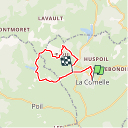
6.2 km | 8 km-effort
1h 44min
Yes
Trail Walking Poil - Circuit du bois du Mousseau - Photo
Walking
martinjacque

Walking

Easy
(1)
Poil, Bourgogne-Franche-Comté, Nièvre, France
8.4 km | 10.9 km-effort
2h 29min
Yes
Trail Walking Saint-Léger-sous-Beuvray - Des manoirs en seigneuries - Photo
Walking
martinjacque

Walking

Easy
(1)
Saint-Léger-sous-Beuvray, Bourgogne-Franche-Comté, Saône-et-Loire, France
7.1 km | 9.9 km-effort
2h 5min
Yes
Trail On foot Étang-sur-Arroux - Tour de la Butte de la Perrière - Photo
On foot
GUIDE+

On foot

Easy
Étang-sur-Arroux, Bourgogne-Franche-Comté, Saône-et-Loire, France
9.9 km | 11.5 km-effort
2h 36min
No
Trail On foot Saint-Didier-sur-Arroux - La vallée de la Bra - Photo
On foot
GUIDE+

On foot

Easy
Saint-Didier-sur-Arroux, Bourgogne-Franche-Comté, Saône-et-Loire, France
7.5 km | 9.1 km-effort
2h 3min
No
Trail On foot La Comelle - Le Jeu et les Moulins - Photo
On foot
GUIDE+

On foot

Easy
La Comelle, Bourgogne-Franche-Comté, Saône-et-Loire, France
4.8 km | 6.1 km-effort
1h 22min
No
Trail On foot Saint-Léger-sous-Beuvray - La Chataigneraie - Photo
On foot
GUIDE+

On foot

Easy
Saint-Léger-sous-Beuvray, Bourgogne-Franche-Comté, Saône-et-Loire, France
4.9 km | 6.4 km-effort
1h 26min
No
Trail Walking Saint-Léger-sous-Beuvray -
Walking
LucThomaere

Walking

Difficult
Saint-Léger-sous-Beuvray, Bourgogne-Franche-Comté, Saône-et-Loire, France
12.2 km | 16.2 km-effort
3h 41min
Yes
Trail Walking Poil - circuit du bois du Mousseau, Poil - Photo
Walking
martinjacque

Walking

Very easy
(1)
Poil, Bourgogne-Franche-Comté, Nièvre, France
5 km | 5.9 km-effort
1h 42min
Yes


Close
My subscriptions