Trail Walking Almont-les-Junies - 2020_07_Le Cabanou_allongé - Photo

2020_07_Le Cabanou_allongé

© OpenStreetMap contributors
Length
Length
11.5 km
Max alt
Max alt
460 m
Uphill gradient
Uphill gradient
329 m
Km-Effort
Km-Effort  
15.9 km
Min alt
Min alt
268 m
Downhill gradient
Downhill gradient
330 m
Boucle
Boucle
Yes
Creation date :
2020-04-27 13:03:31.288
Updated on :
2020-04-27 13:05:31.553

(0 Reviews)

Walking
Walking
2h40
Difficulty : Medium

Scan this QR Code to open this trail in the SityTrail application

FREE GPS app for hiking

Logo SityTrail SityTrail

IGN / Geographical institutes

Download SityTrail from the App Store Download SityTrail from Google Play

Logo SityTrail SityTrail World

The world is yours!

Download SityTrail from the App Store Download SityTrail from Google Play Download SityTrail on Huawei AppGallery

About

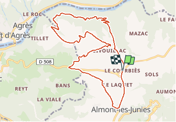
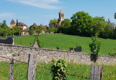
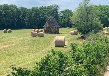
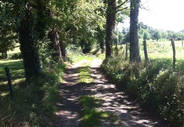
Trail Walking of 11.5 km to be discovered at Occitania, Aveyron, Almont-les-Junies. This trail is proposed by jeanlucien.

Description

Balisage Jaune jusqu'à Ginouilhac.
Ensuite sans balisage connu jusqu'à Almont les Junies et retour parking

Elevation profile

Positioning

Country:
France
Region :
Occitania
Department/Province :
Aveyron
Municipality :
Almont-les-Junies
Location:
Unknown
Start:(UTM)
444003 ; 4939392 (31T) N.

Trails nearby

Trail Other activity Decazeville - compostelle 2017 mt - Photo
Other activity
MAITHE

Other activity

Very easy
(5)
Decazeville, Occitania, Aveyron, France
214 km | 295 km-effort
1666h 40min
No
Trail Walking Conques-en-Rouergue - Les Pelies La Vinzelle : boucle rapide - Photo
Walking
lullaby92

Walking

Easy
(1)
Conques-en-Rouergue, Occitania, Aveyron, France
5.4 km | 8.8 km-effort
3h 19min
Yes
Trail Walking Conques-en-Rouergue - La Vinzelle - Grand Vabre - Photo
Walking
tracegps

Walking

Medium
(3)
Conques-en-Rouergue, Occitania, Aveyron, France
6.7 km | 11.1 km-effort
3h 30min
Yes
Trail Walking Livinhac-le-Haut - Livinhac le Haut - Figeac - Chemin de St-Jacques de Compostelle - Photo
Walking
tracegps

Walking

Very difficult
(4)
Livinhac-le-Haut, Occitania, Aveyron, France
26 km | 33 km-effort
5h 0min
No
Trail On foot Conques-en-Rouergue - Terra trail 10 - Photo
On foot
GUIDE+

On foot

Difficult
Conques-en-Rouergue, Occitania, Aveyron, France
22 km | 34 km-effort
7h 41min
Yes
Trail Walking Livinhac-le-Haut - Levinhac le Haut Figeac Avril  2018 - Photo
Walking
GUIDE
Kargil

Walking

Medium
Livinhac-le-Haut, Occitania, Aveyron, France
24 km | 31 km-effort
6h 27min
No
Trail Walking Decazeville - Étape 12 Decazeville a Figeac - Photo
Walking
lesduj

Walking

Medium
Decazeville, Occitania, Aveyron, France
29 km | 38 km-effort
6h 27min
No
Trail On foot Conques-en-Rouergue - Tieulet - Photo
On foot
GUIDE+

On foot

Easy
(1)
Conques-en-Rouergue, Occitania, Aveyron, France
6.6 km | 10.5 km-effort
2h 22min
No
Trail Walking Livinhac-le-Haut - Livinhac le Haut vers Figeac - Photo
Walking
choubaka77

Walking

Medium
Livinhac-le-Haut, Occitania, Aveyron, France
25 km | 32 km-effort
6h 1min
No


Close
My subscriptions