Trail Walking Beure - mercureau - fontain - arguel - Photo

mercureau - fontain - arguel

© OpenStreetMap contributors
Length
Length
7.9 km
Max alt
Max alt
504 m
Uphill gradient
Uphill gradient
251 m
Km-Effort
Km-Effort  
11.2 km
Min alt
Min alt
301 m
Downhill gradient
Downhill gradient
245 m
Boucle
Boucle
Yes
Creation date :
2020-04-25 12:06:53.325
Updated on :
2021-11-24 16:26:48.668

(0 Reviews)

Walking
Walking
2h15
Difficulty : Easy

Scan this QR Code to open this trail in the SityTrail application

FREE GPS app for hiking

Logo SityTrail SityTrail

IGN / Geographical institutes

Download SityTrail from the App Store Download SityTrail from Google Play

Logo SityTrail SityTrail World

The world is yours!

Download SityTrail from the App Store Download SityTrail from Google Play Download SityTrail on Huawei AppGallery

About

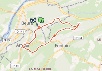
Trail Walking of 7.9 km to be discovered at Bourgogne-Franche-Comté, Doubs, Beure. This trail is proposed by eltonnermou.

Description

Randonnée à faire en famille ; ce  parcours pédestre vous entrainera le long du ruisseau "les mercureaux" (les écrevisses ont-elles disparues ? mais d'autres animaux méritent aussi l'observation).
Après avoir traversé le village d'Arguel dans la descente un peu rapide observez sous vos pieds les traces de la voie celtique/romaine . Profitez des nombreux points de vue tout au long du parcours en sous bois et sur le parcours des crêtes.   Avec un peu de chance, vous surprendrez des chamois sur les pentes escarpées du secteur. Vous pourrez apprécier la diversité de la flore.
Admirer les  cascades lors de la descente vers votre parking.

Elevation profile

Photos

21 photos in total. Please click on a photo to see them all in the gallery.

Positioning

Country:
France
Region :
Bourgogne-Franche-Comté
Department/Province :
Doubs
Municipality :
Beure
Location:
Unknown
Start:(UTM)
273616 ; 5232370 (32T) N.

Trails nearby

Trail Walking Beure - Beure de la pisseur au mercureau  - Photo
Walking
eltonnermou

Walking

Difficult
(1)
Beure, Bourgogne-Franche-Comté, Doubs, France
16.8 km | 24 km-effort
3h 48min
Yes
Trail Walking Beure -
Walking
eltonnermou

Walking

Medium
(1)
Beure, Bourgogne-Franche-Comté, Doubs, France
15.7 km | 22 km-effort
6h 35min
Yes
Trail Walking Montfaucon - Du chateau au fort de Monfaucon - Photo
Walking
yew

Walking

Easy
(1)
Montfaucon, Bourgogne-Franche-Comté, Doubs, France
6.9 km | 9.3 km-effort
1h 55min
Yes
Trail Walking Fontain - fontain - fort de Fontain - forêt de Fontain - Photo
Walking
eltonnermou

Walking

Very easy
(1)
Fontain, Bourgogne-Franche-Comté, Doubs, France
10.9 km | 14 km-effort
3h 11min
Yes
Trail On foot Fontain - Grande Boucle de Fontain - Photo
On foot
GUIDE+

On foot

Easy
Fontain, Bourgogne-Franche-Comté, Doubs, France
10 km | 13.2 km-effort
2h 59min
Yes
Trail On foot Morre - Sentier des Buis - Photo
On foot
GUIDE+

On foot

Easy
Morre, Bourgogne-Franche-Comté, Doubs, France
6.4 km | 9 km-effort
2h 2min
Yes
Trail On foot Fontain - Sentier des Grands Prés - Photo
On foot
GUIDE+

On foot

Easy
Fontain, Bourgogne-Franche-Comté, Doubs, France
6.6 km | 9.6 km-effort
2h 10min
Yes
Trail On foot Besançon - Circuit de Planoise - Photo
On foot
GUIDE+

On foot

Easy
Besançon, Bourgogne-Franche-Comté, Doubs, France
4.6 km | 7.6 km-effort
1h 43min
Yes
Trail On foot Besançon - Circuit du Fort de Chaudanne - Photo
On foot
GUIDE+

On foot

Easy
Besançon, Bourgogne-Franche-Comté, Doubs, France
6 km | 8.7 km-effort
1h 59min
Yes


Close
My subscriptions