Trail Mountain bike Wacquemoulin - Le chemin des Chars - Photo

Le chemin des Chars

© OpenStreetMap contributors
Length
Length
79 km
Max alt
Max alt
145 m
Uphill gradient
Uphill gradient
880 m
Km-Effort
Km-Effort  
91 km
Min alt
Min alt
56 m
Downhill gradient
Downhill gradient
881 m
Boucle
Boucle
No
Creation date :
2014-12-10 00:00:00.0
Updated on :
2014-12-10 00:00:00.0

(1 Reviews)

Mountain bike
Mountain bike
7h00
Difficulty : Medium

Scan this QR Code to open this trail in the SityTrail application

FREE GPS app for hiking

Logo SityTrail SityTrail

IGN / Geographical institutes

Download SityTrail from the App Store Download SityTrail from Google Play

Logo SityTrail SityTrail World

The world is yours!

Download SityTrail from the App Store Download SityTrail from Google Play Download SityTrail on Huawei AppGallery

About

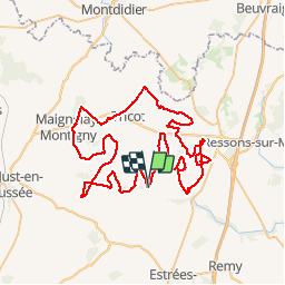
Trail Mountain bike of 79 km to be discovered at Hauts-de-France, Oise, Wacquemoulin. This trail is proposed by azerty.69696.

Description

Sortie VTT sur le chemin de la mémoire des chars.Départ de Wacquemoulin, 81 km de pistes et de routes de campagne en 7 heures.Très bon balisage, juste une balise invisible en sortant du bois de Montgérain.infos surhttp://www.oise-randonnee.com/A-velo/Itineraires-a-velo/Circuits-VTT-VTC/(offre)/RANDOPIC06000043

Elevation profile

Points of interest

Point of interest Courcelles-Epayelles - [EVT60] Courcelles Epayelles - Circuit des Chars. - Photo
azerty.69696
COURCELLES-EPAYELLES 
Point of interest Wacquemoulin - [EVT60] Wacquemoulin - La Gare. - Photo
azerty.69696
Point of interest Ménévillers - [EVT60] Menevillers - la Place du Village. - Photo
azerty.69696
Point of interest Ménévillers - IMG_00011 - Photo
azerty.69696
MÉNÉVILLERS 
Point of interest Ménévillers - IMG_00021 - Photo
azerty.69696
MÉNÉVILLERS 
Point of interest Maignelay-Montigny - IMG_00041 - Photo
azerty.69696
MAIGNELAY-MONTIGNY 
Point of interest Coivrel - IMG_00051 - Photo
azerty.69696
COIVREL 
Point of interest Courcelles-Epayelles - IMG_00061 - Photo
azerty.69696
COURCELLES-EPAYELLES 
Point of interest Lataule - IMG_00071 - Photo
azerty.69696
LATAULE 
Point of interest Gournay-sur-Aronde - IMG_00081 - Photo
azerty.69696
GOURNAY-SUR-ARONDE 
Point of interest Gournay-sur-Aronde - IMG_00091 - Photo
azerty.69696
GOURNAY-SUR-ARONDE 
Point of interest Méry-la-Bataille - IMG_00101 - Photo
azerty.69696
MÉRY-LA-BATAILLE 

Positioning

Country:
France
Region :
Hauts-de-France
Department/Province :
Oise
Municipality :
Wacquemoulin
Location:
Unknown
Start:(UTM)
471885 ; 5483437 (31U) N.

Comments

Please log in to post a review or rate the element


très bien


Trails nearby

Trail Walking Saint-Martin-aux-Bois - La vallée rouge à St Martin aux bois - Photo
Walking
José800

Walking

Medium
Saint-Martin-aux-Bois, Hauts-de-France, Oise, France
14.4 km | 16.7 km-effort
3h 26min
Yes
Trail Equestrian Gournay-sur-Aronde - Gournay sur Aronde - Circuit de la Somme d'Or - Photo
Equestrian
tracegps

Equestrian

Medium
Gournay-sur-Aronde, Hauts-de-France, Oise, France
5.7 km | 6.9 km-effort
1h 0min
Yes
Trail Mountain bike Gournay-sur-Aronde - Gournay sur Aronde - Circuit de la Somme d'Or - Photo
Mountain bike
tracegps

Mountain bike

Easy
Gournay-sur-Aronde, Hauts-de-France, Oise, France
5.7 km | 6.9 km-effort
30min
Yes
Trail Walking Gournay-sur-Aronde - Gournay sur Aronde - Circuit de la Somme d'Or - Photo
Walking
tracegps

Walking

Easy
Gournay-sur-Aronde, Hauts-de-France, Oise, France
5.7 km | 6.9 km-effort
1h 19min
Yes
Trail Walking Cressonsacq - 210603  - Photo
Walking
fab1761

Walking

Very easy
Cressonsacq, Hauts-de-France, Oise, France
3.4 km | 3.6 km-effort
45min
Yes
Trail Mountain bike Cressonsacq - 200829 - Photo
Mountain bike
fab1761

Mountain bike

Easy
Cressonsacq, Hauts-de-France, Oise, France
7.8 km | 8.7 km-effort
34min
Yes
Trail Walking Cressonsacq - 13- Le chemin des châteaux - Photo
Walking
fitz2014

Walking

Easy
Cressonsacq, Hauts-de-France, Oise, France
10.4 km | 11.7 km-effort
2h 16min
Yes
Trail On foot Saint-Martin-aux-Bois - Le chemin de la vallée rouge  - Photo
On foot
José800

On foot

Easy
Saint-Martin-aux-Bois, Hauts-de-France, Oise, France
11.6 km | 13.8 km-effort
3h 7min
Yes
Trail On foot Saint-Martin-aux-Bois - Le chemin de laVallée rouge - Photo
On foot
José800

On foot

Easy
Saint-Martin-aux-Bois, Hauts-de-France, Oise, France
9.5 km | 11.2 km-effort
2h 32min
Yes


Close
My subscriptions