Trail Walking Curvalle - 81_Miolles - Photo
 jab31
jab31

User

© OpenStreetMap contributors
Length
Length
15.1 km
Max alt
Max alt
553 m
Uphill gradient
Uphill gradient
622 m
Km-Effort
Km-Effort  
23 km
Min alt
Min alt
271 m
Downhill gradient
Downhill gradient
628 m
Boucle
Boucle
Yes
Creation date :
2020-04-08 06:56:08.715
Updated on :
2020-12-28 14:59:28.353

(0 Reviews)

Walking
Walking
--
Difficulty : Unknown

Scan this QR Code to open this trail in the SityTrail application

FREE GPS app for hiking

Logo SityTrail SityTrail

IGN / Geographical institutes

Download SityTrail from the App Store Download SityTrail from Google Play

Logo SityTrail SityTrail World

The world is yours!

Download SityTrail from the App Store Download SityTrail from Google Play Download SityTrail on Huawei AppGallery

About

Trail Walking of 15.1 km to be discovered at Occitania, Tarn, Curvalle. This trail is proposed by jab31.

Description

Sentiers de vignes et vergers: rando Tarn
et aller retour à Balaguier sur Rance

Elevation profile

Positioning

Country:
France
Region :
Occitania
Department/Province :
Tarn
Municipality :
Curvalle
Location:
Unknown
Start:(UTM)
462450 ; 4860641 (31T) N.

Trails nearby

Trail Walking Plaisance - plaisance est - Photo
Walking
CASSISFRAMBOISE

Walking

Difficult
Plaisance, Occitania, Aveyron, France
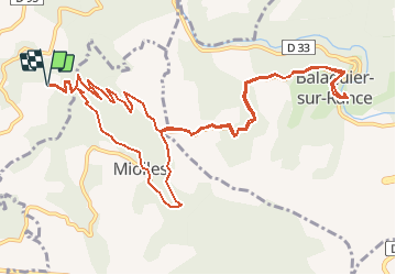
21 km | 32 km-effort
5h 44min
Yes
Trail Walking Plaisance - 3 sommets - Photo
Walking
FrançoisB

Walking

Very difficult
Plaisance, Occitania, Aveyron, France
23 km | 39 km-effort
7h 15min
Yes
Trail Walking Plaisance - la Rouquette  - Photo
Walking
FrançoisB

Walking

Difficult
Plaisance, Occitania, Aveyron, France
10.9 km | 16.2 km-effort
48min
Yes
Trail sport Miolles - Miolle si - Photo
sport
camares

sport

Very easy
Miolles, Occitania, Tarn, France
7.7 km | 11.6 km-effort
Unknown
Yes
Trail On foot Trébas - Sentier des Sources - Photo
On foot
tercla

On foot

Easy
Trébas, Occitania, Tarn, France
7.1 km | 10.1 km-effort
2h 17min
Yes
Trail Walking Trébas - Sentier de Gaycre par les rivages - Photo
Walking
tercla

Walking

Medium
Trébas, Occitania, Tarn, France
8.7 km | 11.6 km-effort
2h 37min
Yes
Trail Mountain bike Plaisance - vtt 2023 - Photo
Mountain bike
FrançoisB

Mountain bike

Very difficult
Plaisance, Occitania, Aveyron, France
32 km | 45 km-effort
3h 23min
No
Trail Walking Plaisance - sentier du Suc d'Armont - Photo
Walking
FrançoisB

Walking

Difficult
Plaisance, Occitania, Aveyron, France
11.3 km | 16.5 km-effort
45min
Yes
Trail Walking Plaisance - Solages  - Photo
Walking
FrançoisB

Walking

Very difficult
Plaisance, Occitania, Aveyron, France
20 km | 28 km-effort
3h 1min
Yes


Close
My subscriptions