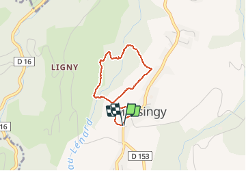
![](/images/other/stat-length.png)
![Trail Walking Massingy - 1 heure - rayon 1 Km Massingy 5 - Photo](https://media.geolcdn.com/t/1900/400/ext.pjpeg?maxdim=2&url=https%3A%2F%2Fstatic1.geolcdn.com%2Fsiteimages%2Fupload%2Ffiles%2F1553511878bg_sport_marche.png)
1 heure - rayon 1 Km Massingy 5
djeepee74
User
![Length](/images/other/stat-length.png)
![Max alt](https://static1.geolcdn.com/siteimages/upload/files/1508320355ic_sort_altitude_max_24dp.png)
![Uphill gradient](https://static1.geolcdn.com/siteimages/upload/files/1508320355ic_sort_den_pos_24dp.png)
![Km-Effort](/images/other/stat-length.png)
![Min alt](https://static1.geolcdn.com/siteimages/upload/files/1508320355ic_sort_altitude_min_24dp.png)
![Downhill gradient](https://static1.geolcdn.com/siteimages/upload/files/1508320355ic_sort_den_neg_24dp.png)
![Boucle](https://static1.geolcdn.com/siteimages/upload/files/16400158638029165_repeat_loop_refresh_sync_direction_icon.png)
![Walking](https://static1.geolcdn.com/sitytour/trail-icons/101.png)
1h00
Difficulty : Easy
![Scan this QR Code to open this trail in the SityTrail application](https://capi.geolives.com/qq0zvz2zws4bq2lad0pu/sitytour/trails/2375384/qr.png?size=200)
FREE GPS app for hiking
About
Trail Walking of 2.7 km to be discovered at Auvergne-Rhône-Alpes, Upper Savoy, Massingy. This trail is proposed by djeepee74.
Description
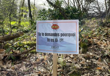
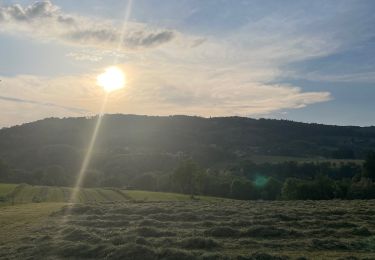
BOUCLE... spéciale confinement !
Adaptez la longueur votre sortie et/ou votre vitesse de marche afin de limiter votre périple à 1 heure au maximum... dans un rayon de 1 Km autour de votre domicile.
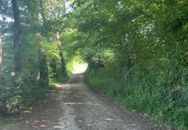
La traversée du "Lénard" pour rejoindre le virage de la "forestière" : C'est très raide, feuillu et glissant... Ne s'y engager que par terrain vraiment sec !
Le sentier n'existe pas... on peut suivre, de temps à autre, quelques traces d'animaux et s'inspirer des courbes de niveau, compte tenu de l'escarpement bien évidemment... mais ça passe !
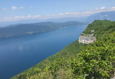
Sinon c'est très pittoresque !
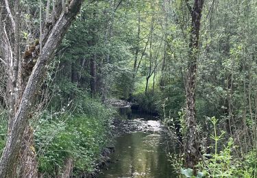
NOTA: Au Km 1.5, à la sortie du "Lénard" sur la boucle de la "forestière", le lit du ruisseau est beaucoup plus proche du chemin que représenté sur les cartes (15 m. tout au plus).
Positioning
Comments
Trails nearby
![Trail Walking Massingy - CLERGEON - Photo](https://media.geolcdn.com/t/375/260/ext.jpg?maxdim=2&url=https%3A%2F%2Fservices.sitytrail.com%2FGeolivesWS%2FDownloadMedia.ashx%3FTrailID%3D474185%26Media%3Dc01eb5a7-bf72-4ffc-98fa-1e923f8f3f43.jpg)
![Walking Walking](https://static1.geolcdn.com/sitytour/trail-icons/101.png)
Walking
![](/images/other/stat-length.png)
![](https://static1.geolcdn.com/siteimages/upload/files/16400158638029165_repeat_loop_refresh_sync_direction_icon.png)
![Trail Walking Entrelacs - SAPENAY / CLERGEON: GRANDE CUVE - Photo](https://media.geolcdn.com/t/375/260/81ea709e-f7b9-477c-93c3-923ab4e12c63.jpg&format=jpg&maxdim=2)
![Walking Walking](https://static1.geolcdn.com/sitytour/trail-icons/101.png)
Walking
![](/images/other/stat-length.png)
![](https://static1.geolcdn.com/siteimages/upload/files/16400158638029165_repeat_loop_refresh_sync_direction_icon.png)
![Trail Walking Entrelacs - ERAT 2024 - Photo](https://media.geolcdn.com/t/375/260/e53aa02e-5e29-4cdc-a141-71a7c9a33ac3.jpg&format=jpg&maxdim=2)
![Walking Walking](https://static1.geolcdn.com/sitytour/trail-icons/101.png)
Walking
![](/images/other/stat-length.png)
![](https://static1.geolcdn.com/siteimages/upload/files/16400158638029165_repeat_loop_refresh_sync_direction_icon.png)
![Trail Walking Entrelacs - 26-05-2023 Belvédère de Chambotte - Retour par Saint Germain et Lépau - Photo](https://media.geolcdn.com/t/375/260/21cca317-b85a-47d7-a962-82924b7d629e.jpg&format=jpg&maxdim=2)
![Walking Walking](https://static1.geolcdn.com/sitytour/trail-icons/101.png)
Walking
![](/images/other/stat-length.png)
![](https://static1.geolcdn.com/siteimages/upload/files/16400158638029165_repeat_loop_refresh_sync_direction_icon.png)
![Trail Walking Entrelacs - Ronde des fours Albens - Photo](https://media.geolcdn.com/t/375/260/f2666e0b-68cf-4aa4-9713-51600128943f.jpg&format=jpg&maxdim=2)
![Walking Walking](https://static1.geolcdn.com/sitytour/trail-icons/101.png)
Walking
![](/images/other/stat-length.png)
![](https://static1.geolcdn.com/siteimages/upload/files/16400158638029165_repeat_loop_refresh_sync_direction_icon.png)
![Trail Walking Entrelacs - La Biolle et Albens - Photo](https://media.geolcdn.com/t/375/260/54787595-584f-43aa-94b8-b759dd22b064.jpg&format=jpg&maxdim=2)
![Walking Walking](https://static1.geolcdn.com/sitytour/trail-icons/101.png)
Walking
![](/images/other/stat-length.png)
![](https://static1.geolcdn.com/siteimages/upload/files/16400158638029165_repeat_loop_refresh_sync_direction_icon.png)
![Trail Walking Entrelacs - Tour d’albens - Photo](https://media.geolcdn.com/t/375/260/31c68e67-710d-4c38-ab3f-955ee8ff9617.jpg&format=jpg&maxdim=2)
![Walking Walking](https://static1.geolcdn.com/sitytour/trail-icons/101.png)
Walking
![](/images/other/stat-length.png)
![](https://static1.geolcdn.com/siteimages/upload/files/16400158638029165_repeat_loop_refresh_sync_direction_icon.png)
![Trail Walking Entrelacs - Ptit tour Albens - Photo](https://media.geolcdn.com/t/375/260/416e9181-dd27-4917-bea8-f883a2086a2a.jpg&format=jpg&maxdim=2)
![Walking Walking](https://static1.geolcdn.com/sitytour/trail-icons/101.png)
Walking
![](/images/other/stat-length.png)
![](https://static1.geolcdn.com/siteimages/upload/files/16400158638029165_repeat_loop_refresh_sync_direction_icon.png)
![Trail Walking Chindrieux - SAPENAY / CLERGEON: COL DU SAPENAY - ROJUX - GRANDE CUVE - MONTCLERGEON - Photo](https://media.geolcdn.com/t/375/260/ec0fabdb-a998-4b52-ac46-d11021fde1e5.jpg&format=jpg&maxdim=2)
![Walking Walking](https://static1.geolcdn.com/sitytour/trail-icons/101.png)
Walking
![](/images/other/stat-length.png)
![](https://static1.geolcdn.com/siteimages/upload/files/16400158638029165_repeat_loop_refresh_sync_direction_icon.png)