![](/images/other/stat-length.png)
La Soufrière et le retour par le Col de l'Échelle
ETMU5496
User
![Length](/images/other/stat-length.png)
![Max alt](https://static1.geolcdn.com/siteimages/upload/files/1508320355ic_sort_altitude_max_24dp.png)
![Uphill gradient](https://static1.geolcdn.com/siteimages/upload/files/1508320355ic_sort_den_pos_24dp.png)
![Km-Effort](/images/other/stat-length.png)
![Min alt](https://static1.geolcdn.com/siteimages/upload/files/1508320355ic_sort_altitude_min_24dp.png)
![Downhill gradient](https://static1.geolcdn.com/siteimages/upload/files/1508320355ic_sort_den_neg_24dp.png)
![Boucle](https://static1.geolcdn.com/siteimages/upload/files/16400158638029165_repeat_loop_refresh_sync_direction_icon.png)
![On foot](https://static1.geolcdn.com/sitytour/trail-icons/100.png)
--
Difficulty : Difficult
![Scan this QR Code to open this trail in the SityTrail application](https://capi.geolives.com/qq0zvz2zws4bq2lad0pu/sitytour/trails/2373078/qr.png?size=200)
FREE GPS app for hiking
About
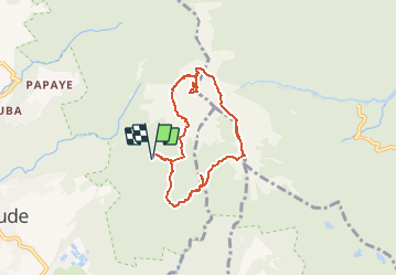
Trail On foot of 9.2 km to be discovered at Guadeloupe, Unknown, Saint-Claude. This trail is proposed by ETMU5496.
Description
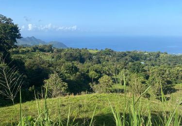
Un joli parcours au départ des bains jaunes pour une classique ascension de la soufrière et retour par le col de l'échelle.
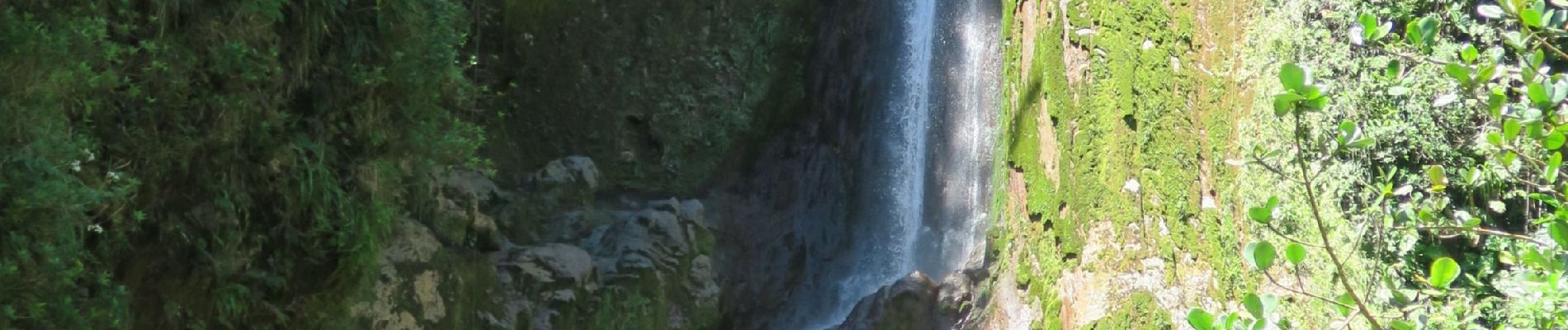
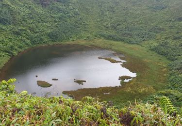
Eviter un retour direct et préférer vous diriger en direction de la citerne pour emprunter ensuite la trace de l'armistice et aller voir la chute du galion (une corde fixée sur la roche permet de se hisser au plus près car la pente est sévère).
Retour ensuite par le sentier qui ramène au pas du Roy puis aux bains jaunes et le parking de départ sur la route.
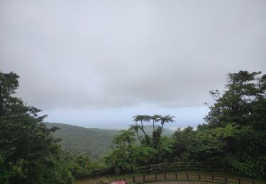
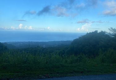
remarque : profiter du paysage au passage dans la forêt qui ramène au pas du Roy pour apercevoir l'archipel des Saintes.
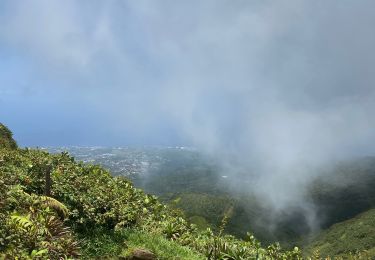
Compter 5h en tout pour prendre le temps d'admirer la vue et l'activité de la Soufrière (fumeroles permanentes) ainsi que les sites de la citerne et de la belle chute du Galion.
Positioning
Comments
Trails nearby
![Trail Other activity Trois-Rivières - trace des poteaux monté armistice l'echelle soufrière carmichael matouba - Photo](https://media.geolcdn.com/t/375/260/ext.jpg?maxdim=2&url=https%3A%2F%2Fservices.sitytrail.com%2FGeolivesWS%2FDownloadMedia.ashx%3FTrailID%3D1004711%26Media%3D20180705171811.jpg)
![Other activity Other activity](https://static1.geolcdn.com/sitytour/trail-icons/900.png)
Other activity
![](/images/other/stat-length.png)
![](https://static1.geolcdn.com/siteimages/upload/files/16400158638029165_repeat_loop_refresh_sync_direction_icon.png)
![Trail Walking Saint-Claude - Guadeloupe - Chute du Galion - La Citerne - Photo](https://media.geolcdn.com/t/375/260/eec73e29-92ac-4bc1-9083-7f50f5622fbd.jpg&format=jpg&maxdim=2)
![Walking Walking](https://static1.geolcdn.com/sitytour/trail-icons/101.png)
Walking
![](/images/other/stat-length.png)
![](https://static1.geolcdn.com/siteimages/upload/files/16400158638029165_repeat_loop_refresh_sync_direction_icon.png)
![Trail Walking Capesterre-Belle-Eau - chutes du carbets 1 et 2 🇬🇵 - Photo](https://media.geolcdn.com/t/375/260/3b2fd3aa-aa4e-4881-8bff-99583d58f440.jpg&format=jpg&maxdim=2)
![Walking Walking](https://static1.geolcdn.com/sitytour/trail-icons/101.png)
Walking
![](/images/other/stat-length.png)
![](https://static1.geolcdn.com/siteimages/upload/files/16400158638029165_repeat_loop_refresh_sync_direction_icon.png)
![Trail Walking Saint-Claude - Guadeloupe - La Soufrière - La Citerne - Photo](https://media.geolcdn.com/t/375/260/b0295af4-d31e-494f-95e4-ba418af820be.jpg&format=jpg&maxdim=2)
![Walking Walking](https://static1.geolcdn.com/sitytour/trail-icons/101.png)
Walking
![](/images/other/stat-length.png)
![](https://static1.geolcdn.com/siteimages/upload/files/16400158638029165_repeat_loop_refresh_sync_direction_icon.png)
![Trail Walking Saint-Claude - la souffriere - Photo](https://media.geolcdn.com/t/375/260/ext.jpg?maxdim=2&url=https%3A%2F%2Fstatic1.geolcdn.com%2Fsiteimages%2Fupload%2Ffiles%2F1553511878bg_sport_marche.png)
![Walking Walking](https://static1.geolcdn.com/sitytour/trail-icons/101.png)
Walking
![](/images/other/stat-length.png)
![](https://static1.geolcdn.com/siteimages/upload/files/16400158638029165_repeat_loop_refresh_sync_direction_icon.png)
![Trail Trail Saint-Claude - Beausoleil - Photo](https://media.geolcdn.com/t/375/260/ca090071-d4cf-4e69-b0ab-dd0d3a28db41.jpg&format=jpg&maxdim=2)
![Trail Trail](https://static1.geolcdn.com/sitytour/trail-icons/104.png)
Trail
![](/images/other/stat-length.png)
![](https://static1.geolcdn.com/siteimages/upload/files/16400158638029165_repeat_loop_refresh_sync_direction_icon.png)
![Trail Trail Saint-Claude - Beausoleil - Photo](https://media.geolcdn.com/t/375/260/7e7bf917-0954-46a9-bcc9-e0e65e77f667.jpg&format=jpg&maxdim=2)
![Trail Trail](https://static1.geolcdn.com/sitytour/trail-icons/104.png)
Trail
![](/images/other/stat-length.png)
![](https://static1.geolcdn.com/siteimages/upload/files/16400158638029165_repeat_loop_refresh_sync_direction_icon.png)
![Trail Trail Saint-Claude - Beau soleil - Photo](https://media.geolcdn.com/t/375/260/6ff951f0-0c00-4cbd-9ada-556e80c71bcd.jpg&format=jpg&maxdim=2)
![Trail Trail](https://static1.geolcdn.com/sitytour/trail-icons/104.png)
Trail
![](/images/other/stat-length.png)
![](https://static1.geolcdn.com/siteimages/upload/files/16400158638029165_repeat_loop_refresh_sync_direction_icon.png)
![Trail Walking Saint-Claude - Bains jaune - Photo](https://media.geolcdn.com/t/375/260/3aab55d0-0b19-475a-b35f-634187ce6c24.jpg&format=jpg&maxdim=2)
![Walking Walking](https://static1.geolcdn.com/sitytour/trail-icons/101.png)
Walking
![](/images/other/stat-length.png)
![](https://static1.geolcdn.com/siteimages/upload/files/16400158638029165_repeat_loop_refresh_sync_direction_icon.png)