![](/images/other/stat-length.png)
![Trail Walking Massingy - 1 heure - rayon 1 Km Massingy - Photo](https://media.geolcdn.com/t/1900/400/ext.pjpeg?maxdim=2&url=https%3A%2F%2Fstatic1.geolcdn.com%2Fsiteimages%2Fupload%2Ffiles%2F1553511878bg_sport_marche.png)
1 heure - rayon 1 Km Massingy
djeepee74
User
![Length](/images/other/stat-length.png)
Length
3.6 km
![Max alt](https://static1.geolcdn.com/siteimages/upload/files/1508320355ic_sort_altitude_max_24dp.png)
Max alt
621 m
![Uphill gradient](https://static1.geolcdn.com/siteimages/upload/files/1508320355ic_sort_den_pos_24dp.png)
Uphill gradient
126 m
![Km-Effort](/images/other/stat-length.png)
Km-Effort
5.3 km
![Min alt](https://static1.geolcdn.com/siteimages/upload/files/1508320355ic_sort_altitude_min_24dp.png)
Min alt
545 m
![Downhill gradient](https://static1.geolcdn.com/siteimages/upload/files/1508320355ic_sort_den_neg_24dp.png)
Downhill gradient
126 m
![Boucle](https://static1.geolcdn.com/siteimages/upload/files/16400158638029165_repeat_loop_refresh_sync_direction_icon.png)
Boucle
Yes
Creation date :
2020-03-27 09:16:30.61
Updated on :
2020-04-21 19:23:01.609
![Walking](https://static1.geolcdn.com/sitytour/trail-icons/101.png)
1h00
Difficulty : Easy
![Scan this QR Code to open this trail in the SityTrail application](https://capi.geolives.com/qq0zvz2zws4bq2lad0pu/sitytour/trails/2370472/qr.png?size=200)
FREE GPS app for hiking
About
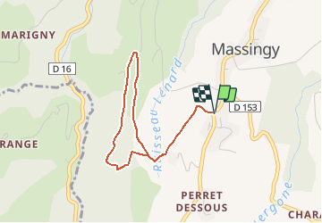
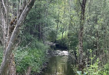
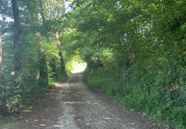
Trail Walking of 3.6 km to be discovered at Auvergne-Rhône-Alpes, Upper Savoy, Massingy. This trail is proposed by djeepee74.
Description
BOUCLE... spéciale confinement !
Adaptez la longueur votre sortie et/ou votre vitesse de marche afin de limiter votre périple à 1 heure au maximum... dans un rayon de 1 Km autour de votre domicile.
Positioning
Country:
France
Region :
Auvergne-Rhône-Alpes
Department/Province :
Upper Savoy
Municipality :
Massingy
Location:
Unknown
Start:(Dec)
Start:(UTM)
726550 ; 5078728 (31T) N.
Comments
Trails nearby
![Trail Walking Chindrieux - Sur les Pas des Huguenots - Chindrieux - Serrières en Chautagne - Photo](https://media.geolcdn.com/t/375/260/ext.jpg?maxdim=2&url=https%3A%2F%2Fservices.sitytrail.com%2FGeolivesWS%2FDownloadMedia.ashx%3FTrailID%3D129664%26Media%3D13193_3.jpg)
![Walking Walking](https://static1.geolcdn.com/sitytour/trail-icons/101.png)
Sur les Pas des Huguenots - Chindrieux - Serrières en Chautagne
Walking
Medium
(1)
Chindrieux,
Auvergne-Rhône-Alpes,
Savoy,
France
![](/images/other/stat-length.png)
9.2 km | 13.8 km-effort
3h 0min
![](https://static1.geolcdn.com/siteimages/upload/files/16400158638029165_repeat_loop_refresh_sync_direction_icon.png)
No
![Trail Walking Massingy - CLERGEON - Photo](https://media.geolcdn.com/t/375/260/ext.jpg?maxdim=2&url=https%3A%2F%2Fservices.sitytrail.com%2FGeolivesWS%2FDownloadMedia.ashx%3FTrailID%3D474185%26Media%3Dc01eb5a7-bf72-4ffc-98fa-1e923f8f3f43.jpg)
![Walking Walking](https://static1.geolcdn.com/sitytour/trail-icons/101.png)
CLERGEON
Walking
Easy
Massingy,
Auvergne-Rhône-Alpes,
Upper Savoy,
France
![](/images/other/stat-length.png)
14.6 km | 22 km-effort
4h 41min
![](https://static1.geolcdn.com/siteimages/upload/files/16400158638029165_repeat_loop_refresh_sync_direction_icon.png)
Yes
![Trail Walking Entrelacs - SAPENAY / CLERGEON: GRANDE CUVE - Photo](https://media.geolcdn.com/t/375/260/81ea709e-f7b9-477c-93c3-923ab4e12c63.jpg&format=jpg&maxdim=2)
![Walking Walking](https://static1.geolcdn.com/sitytour/trail-icons/101.png)
SAPENAY / CLERGEON: GRANDE CUVE
Walking
Very difficult
Entrelacs,
Auvergne-Rhône-Alpes,
Savoy,
France
![](/images/other/stat-length.png)
14.1 km | 21 km-effort
4h 45min
![](https://static1.geolcdn.com/siteimages/upload/files/16400158638029165_repeat_loop_refresh_sync_direction_icon.png)
Yes
![Trail Walking Entrelacs - ERAT 2024 - Photo](https://media.geolcdn.com/t/375/260/e53aa02e-5e29-4cdc-a141-71a7c9a33ac3.jpg&format=jpg&maxdim=2)
![Walking Walking](https://static1.geolcdn.com/sitytour/trail-icons/101.png)
ERAT 2024
Walking
Difficult
Entrelacs,
Auvergne-Rhône-Alpes,
Savoy,
France
![](/images/other/stat-length.png)
13.6 km | 19 km-effort
3h 25min
![](https://static1.geolcdn.com/siteimages/upload/files/16400158638029165_repeat_loop_refresh_sync_direction_icon.png)
Yes
![Trail Walking Entrelacs - 26-05-2023 Belvédère de Chambotte - Retour par Saint Germain et Lépau - Photo](https://media.geolcdn.com/t/375/260/21cca317-b85a-47d7-a962-82924b7d629e.jpg&format=jpg&maxdim=2)
![Walking Walking](https://static1.geolcdn.com/sitytour/trail-icons/101.png)
26-05-2023 Belvédère de Chambotte - Retour par Saint Germain et Lépau
Walking
Very difficult
Entrelacs,
Auvergne-Rhône-Alpes,
Savoy,
France
![](/images/other/stat-length.png)
18.9 km | 28 km-effort
6h 25min
![](https://static1.geolcdn.com/siteimages/upload/files/16400158638029165_repeat_loop_refresh_sync_direction_icon.png)
Yes
![Trail Walking Entrelacs - Ronde des fours Albens - Photo](https://media.geolcdn.com/t/375/260/f2666e0b-68cf-4aa4-9713-51600128943f.jpg&format=jpg&maxdim=2)
![Walking Walking](https://static1.geolcdn.com/sitytour/trail-icons/101.png)
Ronde des fours Albens
Walking
Very difficult
Entrelacs,
Auvergne-Rhône-Alpes,
Savoy,
France
![](/images/other/stat-length.png)
14.9 km | 20 km-effort
4h 1min
![](https://static1.geolcdn.com/siteimages/upload/files/16400158638029165_repeat_loop_refresh_sync_direction_icon.png)
Yes
![Trail Walking Entrelacs - La Biolle et Albens - Photo](https://media.geolcdn.com/t/375/260/54787595-584f-43aa-94b8-b759dd22b064.jpg&format=jpg&maxdim=2)
![Walking Walking](https://static1.geolcdn.com/sitytour/trail-icons/101.png)
La Biolle et Albens
Walking
Medium
Entrelacs,
Auvergne-Rhône-Alpes,
Savoy,
France
![](/images/other/stat-length.png)
7.8 km | 9.2 km-effort
1h 42min
![](https://static1.geolcdn.com/siteimages/upload/files/16400158638029165_repeat_loop_refresh_sync_direction_icon.png)
Yes
![Trail Walking Entrelacs - Tour d’albens - Photo](https://media.geolcdn.com/t/375/260/31c68e67-710d-4c38-ab3f-955ee8ff9617.jpg&format=jpg&maxdim=2)
![Walking Walking](https://static1.geolcdn.com/sitytour/trail-icons/101.png)
Tour d’albens
Walking
Medium
Entrelacs,
Auvergne-Rhône-Alpes,
Savoy,
France
![](/images/other/stat-length.png)
5.6 km | 6.2 km-effort
1h 12min
![](https://static1.geolcdn.com/siteimages/upload/files/16400158638029165_repeat_loop_refresh_sync_direction_icon.png)
Yes
![Trail Walking Entrelacs - Ptit tour Albens - Photo](https://media.geolcdn.com/t/375/260/416e9181-dd27-4917-bea8-f883a2086a2a.jpg&format=jpg&maxdim=2)
![Walking Walking](https://static1.geolcdn.com/sitytour/trail-icons/101.png)
Ptit tour Albens
Walking
Medium
Entrelacs,
Auvergne-Rhône-Alpes,
Savoy,
France
![](/images/other/stat-length.png)
5.8 km | 6.3 km-effort
1h 20min
![](https://static1.geolcdn.com/siteimages/upload/files/16400158638029165_repeat_loop_refresh_sync_direction_icon.png)
Yes