![](/images/other/stat-length.png)
![Trail Cycle Quissac - Quissac-Quissac - Photo](https://media.geolcdn.com/t/1900/400/ext.pjpeg?maxdim=2&url=https%3A%2F%2Fstatic1.geolcdn.com%2Fsiteimages%2Fupload%2Ffiles%2F1524743154velo.jpg)
Quissac-Quissac
bqu34
User
![Length](/images/other/stat-length.png)
![Max alt](https://static1.geolcdn.com/siteimages/upload/files/1508320355ic_sort_altitude_max_24dp.png)
![Uphill gradient](https://static1.geolcdn.com/siteimages/upload/files/1508320355ic_sort_den_pos_24dp.png)
![Km-Effort](/images/other/stat-length.png)
![Min alt](https://static1.geolcdn.com/siteimages/upload/files/1508320355ic_sort_altitude_min_24dp.png)
![Downhill gradient](https://static1.geolcdn.com/siteimages/upload/files/1508320355ic_sort_den_neg_24dp.png)
![Boucle](https://static1.geolcdn.com/siteimages/upload/files/16400158638029165_repeat_loop_refresh_sync_direction_icon.png)
![Cycle](https://static1.geolcdn.com/sitytour/trail-icons/200.png)
7h32
Difficulty : Very easy
![Scan this QR Code to open this trail in the SityTrail application](https://capi.geolives.com/qq0zvz2zws4bq2lad0pu/sitytour/trails/236474/qr.png?size=200)
FREE GPS app for hiking
About
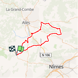
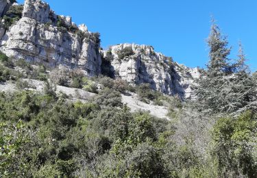
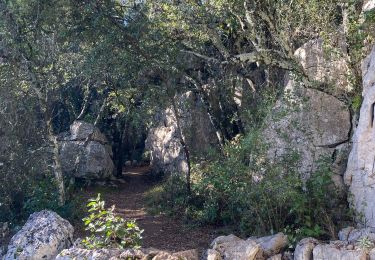
Trail Cycle of 114 km to be discovered at Occitania, Gard, Quissac. This trail is proposed by bqu34.
Description
Quissac. D35. D24. Logrian (1). Puechredon. Canaules et Argentières. Saint Jean de Serres. D109. D907 vers Lédignan. premier CV à gauche. CV à gauche. Mazac. CV. Lédignan. D6110. Massanes. Vezenobres (2). D116. Saint Etienne de l’Olm. près Euzet. Saint Just. D6. Seynes.D218. Belvezet . Le Mas de la Vieille Eglise (3). D218. D979. D125. Labaume. Mas Pontier (4). Gattigues. Foissac. Collorgues. Saint Dézery. D226. Moussac (5). pont suspendu sur le Gardon. CV. La Réglisserie. Plagnol. D939. D8. Nozières. près Domessargues . D8xD124. D8. premier CV à droite. Fontaries. D724 à gauche . D907 à gauche. D215. D215b à droite. Manthes. D215b. D215bxD6110xCV en face. CV en face. CV à gauche. Savignargues. D8. D194. Saint Théodorit.Quissac.
Positioning
Comments
Trails nearby
![Trail Walking Quissac - Quissac - Photo](https://media.geolcdn.com/t/375/260/ext.jpg?maxdim=2&url=https%3A%2F%2Fservices.sitytrail.com%2FGeolivesWS%2FDownloadMedia.ashx%3FTrailID%3D233243%26Media%3Dfix__20131117121007.jpg)
![Walking Walking](https://static1.geolcdn.com/sitytour/trail-icons/101.png)
![Trail Walking Orthoux-Sérignac-Quilhan - Sérignac - les Mazes - Bragassargues - Photo](https://media.geolcdn.com/t/375/260/ext.jpg?maxdim=2&url=https%3A%2F%2Fstatic1.geolcdn.com%2Fsiteimages%2Fupload%2Ffiles%2F1553511878bg_sport_marche.png)
![Walking Walking](https://static1.geolcdn.com/sitytour/trail-icons/101.png)
Walking
![](/images/other/stat-length.png)
![](https://static1.geolcdn.com/siteimages/upload/files/16400158638029165_repeat_loop_refresh_sync_direction_icon.png)
![Trail On foot Liouc - Les chênes de Coutach - Photo](https://media.geolcdn.com/t/375/260/cf45b531-3715-4133-ba5a-b053d48b9be2.jpeg&format=jpg&maxdim=2)
![On foot On foot](https://static1.geolcdn.com/sitytour/trail-icons/100.png)
On foot
![](/images/other/stat-length.png)
![](https://static1.geolcdn.com/siteimages/upload/files/16400158638029165_repeat_loop_refresh_sync_direction_icon.png)
![Trail Horseback riding Orthoux-Sérignac-Quilhan - mas bas - corconnes en boucle - Photo](https://media.geolcdn.com/t/375/260/debc9152-3802-423a-8c6a-1db256dabcad.jpg&format=jpg&maxdim=2)
![Horseback riding Horseback riding](https://static1.geolcdn.com/sitytour/trail-icons/301.png)
Horseback riding
![](/images/other/stat-length.png)
![](https://static1.geolcdn.com/siteimages/upload/files/16400158638029165_repeat_loop_refresh_sync_direction_icon.png)
![Trail Walking Corconne - 30 corconne - Photo](https://media.geolcdn.com/t/375/260/935d2ba4-5725-4112-bf5b-aad99ed037b4.jpg&format=jpg&maxdim=2)
![Walking Walking](https://static1.geolcdn.com/sitytour/trail-icons/101.png)
![Trail Walking Sauve - Sauve, le sentier de l'Aven - Photo](https://media.geolcdn.com/t/375/260/ext.jpg?maxdim=2&url=https%3A%2F%2Fstatic1.geolcdn.com%2Fsiteimages%2Fupload%2Ffiles%2F1553511878bg_sport_marche.png)
![Walking Walking](https://static1.geolcdn.com/sitytour/trail-icons/101.png)
Walking
![](/images/other/stat-length.png)
![](https://static1.geolcdn.com/siteimages/upload/files/16400158638029165_repeat_loop_refresh_sync_direction_icon.png)
![Trail Walking Corconne - Corconne - Photo](https://media.geolcdn.com/t/375/260/ext.jpg?maxdim=2&url=https%3A%2F%2Fstatic1.geolcdn.com%2Fsiteimages%2Fupload%2Ffiles%2F1553511878bg_sport_marche.png)
![Walking Walking](https://static1.geolcdn.com/sitytour/trail-icons/101.png)
![Trail Walking Corconne - CORCONNE - Photo](https://media.geolcdn.com/t/375/260/cec47011-04b4-4f0a-b521-d4e592fe1993.jpg&format=jpg&maxdim=2)
![Walking Walking](https://static1.geolcdn.com/sitytour/trail-icons/101.png)
![Trail Walking Corconne - 30 le mazet des gardes Corconne 8/11/23 - Photo](https://media.geolcdn.com/t/375/260/b14cbd76-fce3-469c-9994-e0217aa95e9f.jpg&format=jpg&maxdim=2)
![Walking Walking](https://static1.geolcdn.com/sitytour/trail-icons/101.png)
Walking
![](/images/other/stat-length.png)
![](https://static1.geolcdn.com/siteimages/upload/files/16400158638029165_repeat_loop_refresh_sync_direction_icon.png)