Trail Walking Altena - 13_03_2020 - Photo
© OpenStreetMap contributors
Length
Length
22 km
Max alt
Max alt
22 m
Uphill gradient
Uphill gradient
94 m
Km-Effort
Km-Effort  
23 km
Min alt
Min alt
-6 m
Downhill gradient
Downhill gradient
92 m
Boucle
Boucle
No
Creation date :
2020-03-13 14:14:09.125
Updated on :
2020-03-13 20:55:27.426

(0 Reviews)

Walking
Walking
6h34
Difficulty : Very easy

Scan this QR Code to open this trail in the SityTrail application

FREE GPS app for hiking

Logo SityTrail SityTrail

IGN / Geographical institutes

Download SityTrail from the App Store Download SityTrail from Google Play

Logo SityTrail SityTrail World

The world is yours!

Download SityTrail from the App Store Download SityTrail from Google Play Download SityTrail on Huawei AppGallery

About

Trail Walking of 22 km to be discovered at North Brabant, Unknown, Altena. This trail is proposed by remi.servel.

Elevation profile

Positioning

Country:
Netherlands
Region :
North Brabant
Department/Province :
Unknown
Municipality :
Altena
Location:
Unknown
Start:(UTM)
623311 ; 5735681 (31U) N.

Trails nearby

Trail Hybrid bike Altena - Dordrecht - Photo
Hybrid bike
beautrix

Hybrid bike

Difficult
Altena, North Brabant, Unknown, Netherlands
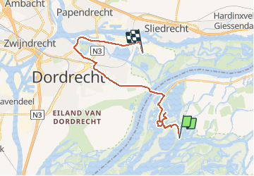
30 km | 32 km-effort
1h 55min
No
Trail Walking Altena - Noord-Brabant - Rondje Boomgat - Photo
Walking
gpstracks

Walking

Very easy
Altena, North Brabant, Unknown, Netherlands
13.7 km | 14.3 km-effort
Unknown
Yes


Close
My subscriptions