![](/images/other/stat-length.png)
![Trail Walking Le Revest-les-Eaux - Mt Caume par les lapiaz - Photo](https://media.geolcdn.com/t/1900/400/ext.pjpeg?maxdim=2&url=https%3A%2F%2Fstatic1.geolcdn.com%2Fsiteimages%2Fupload%2Ffiles%2F1553511878bg_sport_marche.png)
Mt Caume par les lapiaz
jmheydorff
User
![Length](/images/other/stat-length.png)
![Max alt](https://static1.geolcdn.com/siteimages/upload/files/1508320355ic_sort_altitude_max_24dp.png)
![Uphill gradient](https://static1.geolcdn.com/siteimages/upload/files/1508320355ic_sort_den_pos_24dp.png)
![Km-Effort](/images/other/stat-length.png)
![Min alt](https://static1.geolcdn.com/siteimages/upload/files/1508320355ic_sort_altitude_min_24dp.png)
![Downhill gradient](https://static1.geolcdn.com/siteimages/upload/files/1508320355ic_sort_den_neg_24dp.png)
![Boucle](https://static1.geolcdn.com/siteimages/upload/files/16400158638029165_repeat_loop_refresh_sync_direction_icon.png)
![Walking](https://static1.geolcdn.com/sitytour/trail-icons/101.png)
5h42
Difficulty : Very difficult
![Scan this QR Code to open this trail in the SityTrail application](https://capi.geolives.com/qq0zvz2zws4bq2lad0pu/sitytour/trails/236220/qr.png?size=200)
FREE GPS app for hiking
About
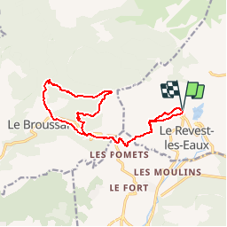
Trail Walking of 16.5 km to be discovered at Provence-Alpes-Côte d'Azur, Var, Le Revest-les-Eaux. This trail is proposed by jmheydorff.
Description
P2T2/3 800m 17 kms 6h00
1°)Départ pkg du Revest CV (alt.190m).
Depuis le carrefour central, descendre SW l'av. des poilus, qui longe la mairie; à 70m, prendre à droite la rue qui passe devant le monument aux mort, toujours tt droit (W); monter cette av de lattre de Tassigny - 25 mn.
2°)après 500m, continuer tt droit à monter dans l'ancien ch. d'Evenos, jusqu'à une falaise que l'on escaladera à l'aide d'une corde (normalement toujours présente); on croise alors le nouveau tracé du GR 51,pour prendre l'ancien tracé (W, puis S), où l'on traverse une 2° microfalaise. Onrejoint le GR après 150m, que l'on suit jusqu'au col du Corps de Garde (alt.391m). - 1h50.
3°)Traverser la route, et prendre WNW la large piste (longeant la route sur 70m) à g. de la citerne ENS8. A 1km, prendre à dr. à la patte d'oie; au carrefour des pistes, à dr. à nouveau (E); à 200m, à dr. et on continue E jusqu'au virage à g. , qui marque le début du lapiaz ( type de géomorphologie déchiquetée, aux aspérités coupantes http://fr.wikipedia.org/wiki/Lapiaz ) - alt. 510m - 2h15
4°) On entame alors une montée de 250m de dénivelé dans ce lapiaz, en cherchant bien les passages , entre les buissons; la partie W comporte peu de buisson, mais ATTENTION: ne pas s'approcher trop du bord de la falaise en. Tout en haut, peu avant lefort (alt.750m), on peut (en faisant attention) aller voir l'arche sous la falaise.
Pour rejoindre la piste qui arrive au fort ouest du Mont Caume, on devra descendre dans le pierrier au Se, , longer n la falaise, et remonter fortement sous le fort - 4h00.
5°) On peut aller visiter les différentes constructions de l'armée, puis descendre en W par le sentier qui longe le flan Nord du Mont Caume. ce sentier retraverse une zone (plus facile) de lapiaz. On croisera différents sentiers (à dr.), que l'on laissera, pour continuer à descendre globalement en WNW; Après un passage de faible pente en ligne de crête, on entre en forêt en descendant plus fortement; on prend le chemin de gauche, qui laisse le chemin principal aller vers l'Est; on descend rapidement en 2 Z jusqu'à la route goudronnée, qui longe le Destel- 5h00
6°) Emprunter S cette route, jusqu'à la RD 62 que l'on traverse, pour prendre le sentier marqué en jaune (Anc. ch. de Signes à Toulon), qui remonte E au col du Corps de Garde - 5h40.
7°) revenir par le même chemin qu'à l'aller, jusqu'à la 1°falaise (que l'on ne descendra pas); prendre alors E le ch. goudronné d'Evenos (GR 51); descendre à g. dans le ch. des laurons puis le ch. des châteaux d'eau; en fin à dr., jusqu'au pkg- 6h20
Positioning
Comments
Trails nearby
![Trail Walking Ollioules - SityTrail - 1041295 - le-destel-grotte-des-joncs - Photo](https://media.geolcdn.com/t/375/260/b00c002a-3425-4f84-ae24-7620ef9e7315.jpg&format=jpg&maxdim=2)
![Walking Walking](https://static1.geolcdn.com/sitytour/trail-icons/101.png)
Walking
![](/images/other/stat-length.png)
![](https://static1.geolcdn.com/siteimages/upload/files/16400158638029165_repeat_loop_refresh_sync_direction_icon.png)
![Trail Walking Solliès-Toucas - Morières : la Garoute et la Baume des Lumes - Photo](https://media.geolcdn.com/t/375/260/3e6ddcf9-f59d-47f4-a0ee-582c12a1d8d8.jpg&format=jpg&maxdim=2)
![Walking Walking](https://static1.geolcdn.com/sitytour/trail-icons/101.png)
Walking
![](/images/other/stat-length.png)
![](https://static1.geolcdn.com/siteimages/upload/files/16400158638029165_repeat_loop_refresh_sync_direction_icon.png)
![Trail Walking Le Revest-les-Eaux - Boucle: La ripelle - Source de la ripelle - Le Chateau de Tourris - Les grottes de sable - La carrière aux fourmis - Les puits renovés de M. Lambicchi - Les ruines des Olivières - La ferme de la Touravelle - à Le Revest-les-Eaux - Photo](https://media.geolcdn.com/t/375/260/0dbff04b-2a84-4eed-a6e8-7a56bc074382.jpg&format=jpg&maxdim=2)
![Walking Walking](https://static1.geolcdn.com/sitytour/trail-icons/101.png)
Walking
![](/images/other/stat-length.png)
![](https://static1.geolcdn.com/siteimages/upload/files/16400158638029165_repeat_loop_refresh_sync_direction_icon.png)
![Trail Walking Toulon - Faron versant Nord - Photo](https://media.geolcdn.com/t/375/260/40a1f88d-10a7-4595-84a1-0086eecb7f84.jpg&format=jpg&maxdim=2)
![Walking Walking](https://static1.geolcdn.com/sitytour/trail-icons/101.png)
Walking
![](/images/other/stat-length.png)
![](https://static1.geolcdn.com/siteimages/upload/files/16400158638029165_repeat_loop_refresh_sync_direction_icon.png)
![Trail Walking Toulon - Faron côté nord - Photo](https://media.geolcdn.com/t/375/260/1a97f987-c174-4fc8-a435-d00586c57288.jpg&format=jpg&maxdim=2)
![Walking Walking](https://static1.geolcdn.com/sitytour/trail-icons/101.png)
Walking
![](/images/other/stat-length.png)
![](https://static1.geolcdn.com/siteimages/upload/files/16400158638029165_repeat_loop_refresh_sync_direction_icon.png)
![Trail Walking Solliès-Toucas - SityTrail - siou blanc - Photo](https://media.geolcdn.com/t/375/260/2137f2fb-f7c1-49df-9712-76654d4b67c0.jpg&format=jpg&maxdim=2)
![Walking Walking](https://static1.geolcdn.com/sitytour/trail-icons/101.png)
Walking
![](/images/other/stat-length.png)
![](https://static1.geolcdn.com/siteimages/upload/files/16400158638029165_repeat_loop_refresh_sync_direction_icon.png)
![Trail Walking Le Revest-les-Eaux - 83 barrage revest les eaux 24-05-2021 - Photo](https://media.geolcdn.com/t/375/260/1106c6f7-fedf-4077-96a1-b48580038b53.jpg&format=jpg&maxdim=2)
![Walking Walking](https://static1.geolcdn.com/sitytour/trail-icons/101.png)
Walking
![](/images/other/stat-length.png)
![](https://static1.geolcdn.com/siteimages/upload/files/16400158638029165_repeat_loop_refresh_sync_direction_icon.png)
![Trail Walking La Valette-du-Var - SityTrail - Le tour du coudon - Photo](https://media.geolcdn.com/t/375/260/c1a593ce-5178-4a51-a2b4-9401a3556db4.jpg&format=jpg&maxdim=2)
![Walking Walking](https://static1.geolcdn.com/sitytour/trail-icons/101.png)
Walking
![](/images/other/stat-length.png)
![](https://static1.geolcdn.com/siteimages/upload/files/16400158638029165_repeat_loop_refresh_sync_direction_icon.png)
![Trail Walking Toulon - Tour Du Baou par falaises - Photo](https://media.geolcdn.com/t/375/260/ext.jpg?maxdim=2&url=https%3A%2F%2Fservices.sitytrail.com%2FGeolivesWS%2FDownloadMedia.ashx%3FTrailID%3D166161%26Media%3D20121215151840.jpeg)
![Walking Walking](https://static1.geolcdn.com/sitytour/trail-icons/101.png)
Walking
![](/images/other/stat-length.png)
![](https://static1.geolcdn.com/siteimages/upload/files/16400158638029165_repeat_loop_refresh_sync_direction_icon.png)