![](/images/other/stat-length.png)
![Trail Walking Nestier - NESTIER le mont Ares Fait en reco G3 2359726 - Photo](https://media.geolcdn.com/t/1900/400/4a952944-a170-493f-9101-8b5c3a4eb372.jpg&format=pjpeg&maxdim=2)
NESTIER le mont Ares Fait en reco G3 2359726
marmotte65
User GUIDE
![Length](/images/other/stat-length.png)
![Max alt](https://static1.geolcdn.com/siteimages/upload/files/1508320355ic_sort_altitude_max_24dp.png)
![Uphill gradient](https://static1.geolcdn.com/siteimages/upload/files/1508320355ic_sort_den_pos_24dp.png)
![Km-Effort](/images/other/stat-length.png)
![Min alt](https://static1.geolcdn.com/siteimages/upload/files/1508320355ic_sort_altitude_min_24dp.png)
![Downhill gradient](https://static1.geolcdn.com/siteimages/upload/files/1508320355ic_sort_den_neg_24dp.png)
![Boucle](https://static1.geolcdn.com/siteimages/upload/files/16400158638029165_repeat_loop_refresh_sync_direction_icon.png)
![Walking](https://static1.geolcdn.com/sitytour/trail-icons/101.png)
6h23
Difficulty : Medium
![Scan this QR Code to open this trail in the SityTrail application](https://capi.geolives.com/qq0zvz2zws4bq2lad0pu/sitytour/trails/2359726/qr.png?size=200)
FREE GPS app for hiking
About
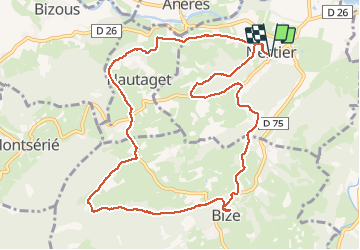
Trail Walking of 12.6 km to be discovered at Occitania, Hautespyrenees, Nestier. This trail is proposed by marmotte65.
Description
Départ de la maison 1h03 de route et autoroute sortie 16 puis vers La Barthe de Neste / Tuzaguet / Aneres / Nestier 82 km.
soit au total 164 km et 8€ de péage A/R
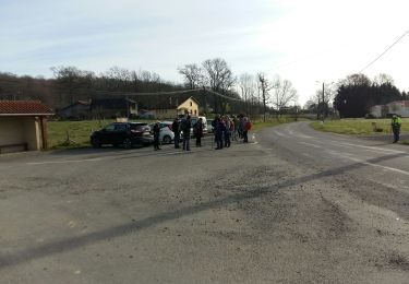
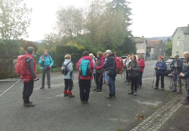
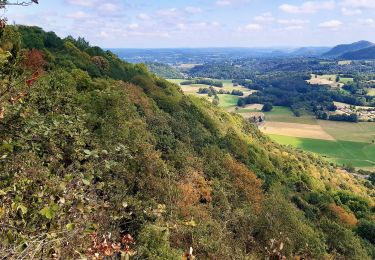
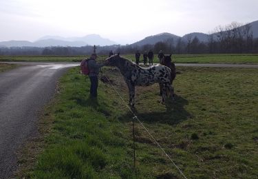
Au départ de la mairie de Nestier, dominé par le mont Arès et son sanctuaire, cette balade se déroule au cœur des premières ondulations du piémont pyrénéen.
avant de refaire cette rando tant que les sentiers seront encombres de la sorte , tel à la mairie de Nestier ( 05 62 39 73 32 )pour savoir si tout a été dégagé. surtout sur la montée au mont Ares, un détour a du être fait pour éviter cette portion ou un dizaine d'arbres étaient en travers du chemin. suivre l'évolution de ce chantier. cette trace a été légèrement modifiée entre la route et le mont Ares à cause de nombreux arbres couchés sur le sentier.
Positioning
Comments
Trails nearby
![Trail On foot Aventignan - AVENTIGNAN/GARGAS 2871325 - Photo](https://media.geolcdn.com/t/375/260/8cf73b11-1d00-442b-b404-4f874454c278.jpg&format=jpg&maxdim=2)
![On foot On foot](https://static1.geolcdn.com/sitytour/trail-icons/100.png)
On foot
![](/images/other/stat-length.png)
![](https://static1.geolcdn.com/siteimages/upload/files/16400158638029165_repeat_loop_refresh_sync_direction_icon.png)
![Trail Walking Saint-Paul - SAINT PAUL Le tour des lacs G4 2686186 - Photo](https://media.geolcdn.com/t/375/260/182bdeb2-870c-4298-97e0-8e5d21969a33.jpg&format=jpg&maxdim=2)
![Walking Walking](https://static1.geolcdn.com/sitytour/trail-icons/101.png)
Walking
![](/images/other/stat-length.png)
![](https://static1.geolcdn.com/siteimages/upload/files/16400158638029165_repeat_loop_refresh_sync_direction_icon.png)
![Trail Walking Bizous - BIZOUS G4 le tour des monts](https://media.geolcdn.com/t/375/260/18999466-5e31-4ce6-b83a-2030827cd74f.jpg&format=jpg&maxdim=2)
![Walking Walking](https://static1.geolcdn.com/sitytour/trail-icons/101.png)
Walking
![](/images/other/stat-length.png)
![](https://static1.geolcdn.com/siteimages/upload/files/16400158638029165_repeat_loop_refresh_sync_direction_icon.png)
![Trail On foot Hautaget - HAUTAGET autour de Massey G4 10.1 k 275M+](https://media.geolcdn.com/t/375/260/ext.jpg?maxdim=2&url=https%3A%2F%2Fstatic1.geolcdn.com%2Fsiteimages%2Fupload%2Ffiles%2F1545311037marcheuse_200dpi.jpg)
![On foot On foot](https://static1.geolcdn.com/sitytour/trail-icons/100.png)
On foot
![](/images/other/stat-length.png)
![](https://static1.geolcdn.com/siteimages/upload/files/16400158638029165_repeat_loop_refresh_sync_direction_icon.png)
![Trail On foot Montsérié - Promenade du Mont Ergé - Photo](https://media.geolcdn.com/t/375/260/1563b829-db8b-4e00-bbda-db02f138dad7.jpeg&format=jpg&maxdim=2)
![On foot On foot](https://static1.geolcdn.com/sitytour/trail-icons/100.png)
On foot
![](/images/other/stat-length.png)
![](https://static1.geolcdn.com/siteimages/upload/files/16400158638029165_repeat_loop_refresh_sync_direction_icon.png)
![Trail Walking Saint-Paul - G4 Saint Paul - Photo](https://media.geolcdn.com/t/375/260/bc90a9ab-c6db-45a6-881f-19ad783a26d9.jpg&format=jpg&maxdim=2)
![Walking Walking](https://static1.geolcdn.com/sitytour/trail-icons/101.png)
Walking
![](/images/other/stat-length.png)
![](https://static1.geolcdn.com/siteimages/upload/files/16400158638029165_repeat_loop_refresh_sync_direction_icon.png)
![Trail Walking Aventignan - autour de Gargas - Photo](https://media.geolcdn.com/t/375/260/ext.jpg?maxdim=2&url=https%3A%2F%2Fstatic1.geolcdn.com%2Fsiteimages%2Fupload%2Ffiles%2F1553511878bg_sport_marche.png)
![Walking Walking](https://static1.geolcdn.com/sitytour/trail-icons/101.png)
Walking
![](/images/other/stat-length.png)
![](https://static1.geolcdn.com/siteimages/upload/files/16400158638029165_repeat_loop_refresh_sync_direction_icon.png)
![Trail Walking Cuguron - autour de Cuguron - Photo](https://media.geolcdn.com/t/375/260/ext.jpg?maxdim=2&url=https%3A%2F%2Fstatic1.geolcdn.com%2Fsiteimages%2Fupload%2Ffiles%2F1553511878bg_sport_marche.png)
![Walking Walking](https://static1.geolcdn.com/sitytour/trail-icons/101.png)
Walking
![](/images/other/stat-length.png)
![](https://static1.geolcdn.com/siteimages/upload/files/16400158638029165_repeat_loop_refresh_sync_direction_icon.png)
![Trail Walking Montsérié - boucle courant du Mont Herge - Photo](https://media.geolcdn.com/t/375/260/4cf68b76-228a-49a2-a971-1815aaacd10f.jpg&format=jpg&maxdim=2)
![Walking Walking](https://static1.geolcdn.com/sitytour/trail-icons/101.png)
Walking
![](/images/other/stat-length.png)
![](https://static1.geolcdn.com/siteimages/upload/files/16400158638029165_repeat_loop_refresh_sync_direction_icon.png)