![](/images/other/stat-length.png)
![Trail Walking Usclas-du-Bosc - de usclas du bosc vers St privat - Photo](https://media.geolcdn.com/t/1900/400/359ec3c9-6dcb-451b-b360-9dfa24f74e13.jpg&format=pjpeg&maxdim=2)
de usclas du bosc vers St privat
labarone
User
![Length](/images/other/stat-length.png)
Length
20 km
![Max alt](https://static1.geolcdn.com/siteimages/upload/files/1508320355ic_sort_altitude_max_24dp.png)
Max alt
693 m
![Uphill gradient](https://static1.geolcdn.com/siteimages/upload/files/1508320355ic_sort_den_pos_24dp.png)
Uphill gradient
787 m
![Km-Effort](/images/other/stat-length.png)
Km-Effort
31 km
![Min alt](https://static1.geolcdn.com/siteimages/upload/files/1508320355ic_sort_altitude_min_24dp.png)
Min alt
166 m
![Downhill gradient](https://static1.geolcdn.com/siteimages/upload/files/1508320355ic_sort_den_neg_24dp.png)
Downhill gradient
790 m
![Boucle](https://static1.geolcdn.com/siteimages/upload/files/16400158638029165_repeat_loop_refresh_sync_direction_icon.png)
Boucle
Yes
Creation date :
2020-03-03 08:10:03.717
Updated on :
2020-03-03 15:01:20.521
![Walking](https://static1.geolcdn.com/sitytour/trail-icons/101.png)
5h06
Difficulty : Very easy
![Scan this QR Code to open this trail in the SityTrail application](https://capi.geolives.com/qq0zvz2zws4bq2lad0pu/sitytour/trails/2352724/qr.png?size=200)
FREE GPS app for hiking
About
Trail Walking of 20 km to be discovered at Occitania, Hérault, Usclas-du-Bosc. This trail is proposed by labarone.
Description
Belle rando un peu difficile
A visiter village de Saint privat
Positioning
Country:
France
Region :
Occitania
Department/Province :
Hérault
Municipality :
Usclas-du-Bosc
Location:
Unknown
Start:(Dec)
Start:(UTM)
532312 ; 4841372 (31T) N.
Comments
Trails nearby
![Trail Walking Saint-Étienne-de-Gourgas - St Etienne de Gourgas - col de Melanque - Puech haut - Photo](https://media.geolcdn.com/t/375/260/ext.jpg?maxdim=2&url=https%3A%2F%2Fservices.sitytrail.com%2FGeolivesWS%2FDownloadMedia.ashx%3FTrailID%3D334032%26Media%3Decee9542-ae6c-4b78-860f-f4fbe993ce14.jpg)
![Walking Walking](https://static1.geolcdn.com/sitytour/trail-icons/101.png)
St Etienne de Gourgas - col de Melanque - Puech haut
Walking
Medium
(2)
Saint-Étienne-de-Gourgas,
Occitania,
Hérault,
France
![](/images/other/stat-length.png)
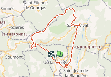
16.7 km | 25 km-effort
5h 22min
![](https://static1.geolcdn.com/siteimages/upload/files/16400158638029165_repeat_loop_refresh_sync_direction_icon.png)
Yes
![Trail Walking Le Bosc - Saint-Alban - Célis - La Roque - Photo](https://media.geolcdn.com/t/375/260/932d7dea-57ce-4b8a-b586-1c6511489398.jpg&format=jpg&maxdim=2)
![Walking Walking](https://static1.geolcdn.com/sitytour/trail-icons/101.png)
Saint-Alban - Célis - La Roque
Walking
Medium
(1)
Le Bosc,
Occitania,
Hérault,
France
![](/images/other/stat-length.png)
5.7 km | 7.9 km-effort
1h 47min
![](https://static1.geolcdn.com/siteimages/upload/files/16400158638029165_repeat_loop_refresh_sync_direction_icon.png)
Yes
![Trail Walking Soumont - Balcons de Soumont - Photo](https://media.geolcdn.com/t/375/260/d9f45190-3768-4750-9561-de3d1f0991af.jpg&format=jpg&maxdim=2)
![Walking Walking](https://static1.geolcdn.com/sitytour/trail-icons/101.png)
Balcons de Soumont
Walking
Medium
(1)
Soumont,
Occitania,
Hérault,
France
![](/images/other/stat-length.png)
8.4 km | 11.9 km-effort
2h 29min
![](https://static1.geolcdn.com/siteimages/upload/files/16400158638029165_repeat_loop_refresh_sync_direction_icon.png)
Yes
![Trail Walking Le Bosc - Le Bosc - prieuré de Grandmont - Le Brédou - Soumont - Photo](https://media.geolcdn.com/t/375/260/ext.jpg?maxdim=2&url=https%3A%2F%2Fservices.sitytrail.com%2FGeolivesWS%2FDownloadMedia.ashx%3FTrailID%3D384816%26Media%3D8c6417b4-a39d-4b75-b1b0-b5a0d180c222.jpg)
![Walking Walking](https://static1.geolcdn.com/sitytour/trail-icons/101.png)
Le Bosc - prieuré de Grandmont - Le Brédou - Soumont
Walking
Medium
(2)
Le Bosc,
Occitania,
Hérault,
France
![](/images/other/stat-length.png)
19.1 km | 28 km-effort
5h 46min
![](https://static1.geolcdn.com/siteimages/upload/files/16400158638029165_repeat_loop_refresh_sync_direction_icon.png)
Yes
![Trail Walking Soumont - Soumont et ses Dolmens - Photo](https://media.geolcdn.com/t/375/260/ext.jpg?maxdim=2&url=https%3A%2F%2Fservices.sitytrail.com%2FGeolivesWS%2FDownloadMedia.ashx%3FTrailID%3D198665%26Media%3D20130616160313.jpg)
![Walking Walking](https://static1.geolcdn.com/sitytour/trail-icons/101.png)
Soumont et ses Dolmens
Walking
Medium
(3)
Soumont,
Occitania,
Hérault,
France
![](/images/other/stat-length.png)
18.2 km | 26 km-effort
5h 56min
![](https://static1.geolcdn.com/siteimages/upload/files/16400158638029165_repeat_loop_refresh_sync_direction_icon.png)
Yes
![Trail Walking Soubès - Cirque du Bout du monde au départ de Soulès - Photo](https://media.geolcdn.com/t/375/260/f51750a0-9c67-4c78-b203-2c61c136c414.jpg&format=jpg&maxdim=2)
![Walking Walking](https://static1.geolcdn.com/sitytour/trail-icons/101.png)
Cirque du Bout du monde au départ de Soulès
Walking
Difficult
Soubès,
Occitania,
Hérault,
France
![](/images/other/stat-length.png)
19.5 km | 30 km-effort
5h 37min
![](https://static1.geolcdn.com/siteimages/upload/files/16400158638029165_repeat_loop_refresh_sync_direction_icon.png)
Yes
![Trail Walking Soumont - Les balcons de Soumont - Photo](https://media.geolcdn.com/t/375/260/ext.jpg?maxdim=2&url=https%3A%2F%2Fstatic1.geolcdn.com%2Fsiteimages%2Fupload%2Ffiles%2F1553511878bg_sport_marche.png)
![Walking Walking](https://static1.geolcdn.com/sitytour/trail-icons/101.png)
Les balcons de Soumont
Walking
Medium
(2)
Soumont,
Occitania,
Hérault,
France
![](/images/other/stat-length.png)
12.5 km | 17.6 km-effort
5h 0min
![](https://static1.geolcdn.com/siteimages/upload/files/16400158638029165_repeat_loop_refresh_sync_direction_icon.png)
Yes
![Trail Walking Saint-Jean-de-la-Blaquière - Les Bois de Homs et de Latude - Photo](https://media.geolcdn.com/t/375/260/ext.jpg?maxdim=2&url=https%3A%2F%2Fstatic1.geolcdn.com%2Fsiteimages%2Fupload%2Ffiles%2F1553511878bg_sport_marche.png)
![Walking Walking](https://static1.geolcdn.com/sitytour/trail-icons/101.png)
Les Bois de Homs et de Latude
Walking
Easy
(1)
Saint-Jean-de-la-Blaquière,
Occitania,
Hérault,
France
![](/images/other/stat-length.png)
9.3 km | 13.1 km-effort
2h 27min
![](https://static1.geolcdn.com/siteimages/upload/files/16400158638029165_repeat_loop_refresh_sync_direction_icon.png)
Yes
![Trail Nordic walking Fozières - Foziéres Soumont 2 8.5kms-20527975 - Photo](https://media.geolcdn.com/t/375/260/1320ab09-98d1-419b-9fb9-cae8d32c32a3.jpg&format=jpg&maxdim=2)
![Nordic walking Nordic walking](https://static1.geolcdn.com/sitytour/trail-icons/102.png)
Foziéres Soumont 2 8.5kms-20527975
Nordic walking
Easy
Fozières,
Occitania,
Hérault,
France
![](/images/other/stat-length.png)
9 km | 12.1 km-effort
1h 50min
![](https://static1.geolcdn.com/siteimages/upload/files/16400158638029165_repeat_loop_refresh_sync_direction_icon.png)
Yes
J ai été trop rapide au moment de l enregistrement. Ce n est pas une rando très facile. Mais plutôt de difficulté moyen plus car il y a des descentes caillouteuses... Donc faire gaffe ! Labarone