![](/images/other/stat-length.png)
![Trail On foot Champs-sur-Marne - Champs s/Marne,Vayres, Noisiel - Photo](https://media.geolcdn.com/t/1900/400/ext.pjpeg?maxdim=2&url=https%3A%2F%2Fstatic1.geolcdn.com%2Fsiteimages%2Fupload%2Ffiles%2F1545311037marcheuse_200dpi.jpg)
Champs s/Marne,Vayres, Noisiel
Surot
User
![Length](/images/other/stat-length.png)
Length
15.5 km
![Max alt](https://static1.geolcdn.com/siteimages/upload/files/1508320355ic_sort_altitude_max_24dp.png)
Max alt
84 m
![Uphill gradient](https://static1.geolcdn.com/siteimages/upload/files/1508320355ic_sort_den_pos_24dp.png)
Uphill gradient
132 m
![Km-Effort](/images/other/stat-length.png)
Km-Effort
17.3 km
![Min alt](https://static1.geolcdn.com/siteimages/upload/files/1508320355ic_sort_altitude_min_24dp.png)
Min alt
35 m
![Downhill gradient](https://static1.geolcdn.com/siteimages/upload/files/1508320355ic_sort_den_neg_24dp.png)
Downhill gradient
132 m
![Boucle](https://static1.geolcdn.com/siteimages/upload/files/16400158638029165_repeat_loop_refresh_sync_direction_icon.png)
Boucle
Yes
Creation date :
2020-03-02 08:40:20.998
Updated on :
2020-03-02 08:46:00.042
![On foot](https://static1.geolcdn.com/sitytour/trail-icons/100.png)
4h10
Difficulty : Medium
![Scan this QR Code to open this trail in the SityTrail application](https://capi.geolives.com/qq0zvz2zws4bq2lad0pu/sitytour/trails/2351291/qr.png?size=200)
FREE GPS app for hiking
About
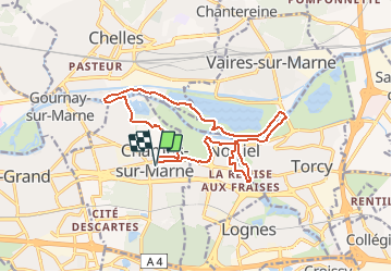
Trail On foot of 15.5 km to be discovered at Ile-de-France, Seine-et-Marne, Champs-sur-Marne. This trail is proposed by Surot.
Description
Boucle au travers du parc du château de Champs sur Marne, bords de Marne et Ile de Vayres, vue sur la chocolaterie Menier et son barrage, Torcy et bords des étangs de Noisiel, son ancienne cité ouvrière et son parc avec sa grille d'honneur. 15,5 km. Pas de dénivelé
Positioning
Country:
France
Region :
Ile-de-France
Department/Province :
Seine-et-Marne
Municipality :
Champs-sur-Marne
Location:
Unknown
Start:(Dec)
Start:(UTM)
470923 ; 5411052 (31U) N.
Comments
Trails nearby
![Trail Walking Chelles - GRP CV-IDF 06 - Photo](https://media.geolcdn.com/t/375/260/3e851a57-05bf-470c-9490-37cd07bf40e9.jpg&format=jpg&maxdim=2)
![Walking Walking](https://static1.geolcdn.com/sitytour/trail-icons/101.png)
GRP CV-IDF 06
Walking
Medium
(1)
Chelles,
Ile-de-France,
Seine-et-Marne,
France
![](/images/other/stat-length.png)
15 km | 16.7 km-effort
3h 47min
![](https://static1.geolcdn.com/siteimages/upload/files/16400158638029165_repeat_loop_refresh_sync_direction_icon.png)
No
![Walking Walking](https://static1.geolcdn.com/sitytour/trail-icons/101.png)
Du Parc de Rentilly au Ru de la Gondoire
Walking
Difficult
(1)
Saint-Thibault-des-Vignes,
Ile-de-France,
Seine-et-Marne,
France
![](/images/other/stat-length.png)
21 km | 24 km-effort
5h 20min
![](https://static1.geolcdn.com/siteimages/upload/files/16400158638029165_repeat_loop_refresh_sync_direction_icon.png)
Yes
![Trail Walking Champs-sur-Marne - Boucle 20 km autour de Champs sur Marne - Photo](https://media.geolcdn.com/t/375/260/e5bc49c5-8534-4b14-8b85-21b9437dca8c.jpg&format=jpg&maxdim=2)
![Walking Walking](https://static1.geolcdn.com/sitytour/trail-icons/101.png)
Boucle 20 km autour de Champs sur Marne
Walking
Easy
Champs-sur-Marne,
Ile-de-France,
Seine-et-Marne,
France
![](/images/other/stat-length.png)
19.8 km | 22 km-effort
4h 29min
![](https://static1.geolcdn.com/siteimages/upload/files/16400158638029165_repeat_loop_refresh_sync_direction_icon.png)
Yes
![Trail Walking Lognes - SityTrail - EvadRando2024-14km - Photo](https://media.geolcdn.com/t/375/260/ext.jpg?maxdim=2&url=https%3A%2F%2Fstatic1.geolcdn.com%2Fsiteimages%2Fupload%2Ffiles%2F1553511878bg_sport_marche.png)
![Walking Walking](https://static1.geolcdn.com/sitytour/trail-icons/101.png)
SityTrail - EvadRando2024-14km
Walking
Difficult
(2)
Lognes,
Ile-de-France,
Seine-et-Marne,
France
![](/images/other/stat-length.png)
12.3 km | 14.1 km-effort
3h 12min
![](https://static1.geolcdn.com/siteimages/upload/files/16400158638029165_repeat_loop_refresh_sync_direction_icon.png)
Yes
![Trail Walking Lognes - SityTrail - Lognes Pontault-Combault 15,4km - Photo](https://media.geolcdn.com/t/375/260/ext.jpg?maxdim=2&url=https%3A%2F%2Fstatic1.geolcdn.com%2Fsiteimages%2Fupload%2Ffiles%2F1553511878bg_sport_marche.png)
![Walking Walking](https://static1.geolcdn.com/sitytour/trail-icons/101.png)
SityTrail - Lognes Pontault-Combault 15,4km
Walking
Difficult
(1)
Lognes,
Ile-de-France,
Seine-et-Marne,
France
![](/images/other/stat-length.png)
16.7 km | 18.3 km-effort
4h 9min
![](https://static1.geolcdn.com/siteimages/upload/files/16400158638029165_repeat_loop_refresh_sync_direction_icon.png)
Yes
![Trail Walking Vaires-sur-Marne - Boucle Vaires sur Marne / Noisiel / Chelles - Photo](https://media.geolcdn.com/t/375/260/449646ea-4419-47cd-8a7f-7bcc77625a1b.jpg&format=jpg&maxdim=2)
![Walking Walking](https://static1.geolcdn.com/sitytour/trail-icons/101.png)
Boucle Vaires sur Marne / Noisiel / Chelles
Walking
Easy
Vaires-sur-Marne,
Ile-de-France,
Seine-et-Marne,
France
![](/images/other/stat-length.png)
21 km | 24 km-effort
4h 33min
![](https://static1.geolcdn.com/siteimages/upload/files/16400158638029165_repeat_loop_refresh_sync_direction_icon.png)
Yes
![Trail Walking Lognes - 12kmVM-année-paire - Photo](https://media.geolcdn.com/t/375/260/ext.jpg?maxdim=2&url=https%3A%2F%2Fstatic1.geolcdn.com%2Fsiteimages%2Fupload%2Ffiles%2F1553511878bg_sport_marche.png)
![Walking Walking](https://static1.geolcdn.com/sitytour/trail-icons/101.png)
12kmVM-année-paire
Walking
Difficult
(1)
Lognes,
Ile-de-France,
Seine-et-Marne,
France
![](/images/other/stat-length.png)
14.3 km | 16.3 km-effort
3h 42min
![](https://static1.geolcdn.com/siteimages/upload/files/16400158638029165_repeat_loop_refresh_sync_direction_icon.png)
Yes
![Trail Walking Gournay-sur-Marne - Boucle Gournay/ Marne - Noisy le Grand - Champs sur Marne - Photo](https://media.geolcdn.com/t/375/260/89921577-96fb-496f-92ce-fb28ab23f5a4.jpg&format=jpg&maxdim=2)
![Walking Walking](https://static1.geolcdn.com/sitytour/trail-icons/101.png)
Boucle Gournay/ Marne - Noisy le Grand - Champs sur Marne
Walking
Very easy
Gournay-sur-Marne,
Ile-de-France,
Seine-Saint-Denis,
France
![](/images/other/stat-length.png)
20 km | 23 km-effort
4h 41min
![](https://static1.geolcdn.com/siteimages/upload/files/16400158638029165_repeat_loop_refresh_sync_direction_icon.png)
Yes
![Trail Walking Saint-Thibault-des-Vignes - Du Parc de Rentilly au Vallon de la Brosse - Photo](https://media.geolcdn.com/t/375/260/ext.jpg?maxdim=2&url=https%3A%2F%2Fstatic1.geolcdn.com%2Fsiteimages%2Fupload%2Ffiles%2F1553511878bg_sport_marche.png)
![Walking Walking](https://static1.geolcdn.com/sitytour/trail-icons/101.png)
Du Parc de Rentilly au Vallon de la Brosse
Walking
Medium
(4)
Saint-Thibault-des-Vignes,
Ile-de-France,
Seine-et-Marne,
France
![](/images/other/stat-length.png)
9.8 km | 11.3 km-effort
2h 33min
![](https://static1.geolcdn.com/siteimages/upload/files/16400158638029165_repeat_loop_refresh_sync_direction_icon.png)
Yes