![](/images/other/stat-length.png)
![Trail Walking Belmont - Belmont -Biol- la Pierre aiguë - Photo](https://media.geolcdn.com/t/1900/400/36b5f13f-9d2a-4a70-b545-3b6da39f7187.jpg&format=pjpeg&maxdim=2)
Belmont -Biol- la Pierre aiguë
mireillemarmonier
User
![Length](/images/other/stat-length.png)
Length
8.9 km
![Max alt](https://static1.geolcdn.com/siteimages/upload/files/1508320355ic_sort_altitude_max_24dp.png)
Max alt
696 m
![Uphill gradient](https://static1.geolcdn.com/siteimages/upload/files/1508320355ic_sort_den_pos_24dp.png)
Uphill gradient
236 m
![Km-Effort](/images/other/stat-length.png)
Km-Effort
12.1 km
![Min alt](https://static1.geolcdn.com/siteimages/upload/files/1508320355ic_sort_altitude_min_24dp.png)
Min alt
611 m
![Downhill gradient](https://static1.geolcdn.com/siteimages/upload/files/1508320355ic_sort_den_neg_24dp.png)
Downhill gradient
237 m
![Boucle](https://static1.geolcdn.com/siteimages/upload/files/16400158638029165_repeat_loop_refresh_sync_direction_icon.png)
Boucle
Yes
Creation date :
2020-03-01 09:10:24.0
Updated on :
2020-03-01 11:48:28.64
![Walking](https://static1.geolcdn.com/sitytour/trail-icons/101.png)
2h37
Difficulty : Medium
![Scan this QR Code to open this trail in the SityTrail application](https://capi.geolives.com/qq0zvz2zws4bq2lad0pu/sitytour/trails/2350474/qr.png?size=200)
FREE GPS app for hiking
About
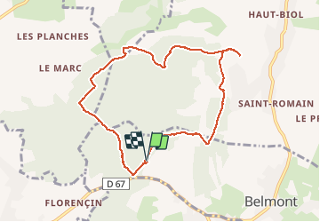
Trail Walking of 8.9 km to be discovered at Auvergne-Rhône-Alpes, Isère, Belmont. This trail is proposed by mireillemarmonier.
Description
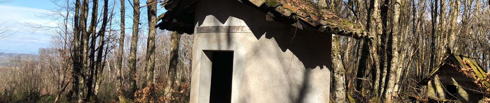
randonnée en forêt - la Pierre aiguë qui délimite 3 cantons ( grand -Lemps /Bourgoin /ST Jean de Bournay) la table d’orientation « au bois » à Biol le haut.
Positioning
Country:
France
Region :
Auvergne-Rhône-Alpes
Department/Province :
Isère
Municipality :
Belmont
Location:
Unknown
Start:(Dec)
Start:(UTM)
682862 ; 5038806 (31T) N.
Comments
Trails nearby
![Trail Walking Belmont - belmont Pierre aiguë - Photo](https://media.geolcdn.com/t/375/260/ext.jpg?maxdim=2&url=https%3A%2F%2Fstatic1.geolcdn.com%2Fsiteimages%2Fupload%2Ffiles%2F1553511878bg_sport_marche.png)
![Walking Walking](https://static1.geolcdn.com/sitytour/trail-icons/101.png)
belmont Pierre aiguë
Walking
Medium
(1)
Belmont,
Auvergne-Rhône-Alpes,
Isère,
France
![](/images/other/stat-length.png)
7.7 km | 10.3 km-effort
2h 20min
![](https://static1.geolcdn.com/siteimages/upload/files/16400158638029165_repeat_loop_refresh_sync_direction_icon.png)
Yes
![Trail Walking Saint-Didier-de-Bizonnes - etang la frette - Photo](https://media.geolcdn.com/t/375/260/95eb8bfb-ff60-4000-9692-87f5d2745b5a.jpg&format=jpg&maxdim=2)
![Walking Walking](https://static1.geolcdn.com/sitytour/trail-icons/101.png)
etang la frette
Walking
Medium
Saint-Didier-de-Bizonnes,
Auvergne-Rhône-Alpes,
Isère,
France
![](/images/other/stat-length.png)
5 km | 6.2 km-effort
1h 17min
![](https://static1.geolcdn.com/siteimages/upload/files/16400158638029165_repeat_loop_refresh_sync_direction_icon.png)
Yes
![Trail Walking Champier - Nantoin - Photo](https://media.geolcdn.com/t/375/260/ext.jpg?maxdim=2&url=https%3A%2F%2Fstatic1.geolcdn.com%2Fsiteimages%2Fupload%2Ffiles%2F1553511878bg_sport_marche.png)
![Walking Walking](https://static1.geolcdn.com/sitytour/trail-icons/101.png)
Nantoin
Walking
Difficult
Champier,
Auvergne-Rhône-Alpes,
Isère,
France
![](/images/other/stat-length.png)
10.5 km | 13 km-effort
3h 19min
![](https://static1.geolcdn.com/siteimages/upload/files/16400158638029165_repeat_loop_refresh_sync_direction_icon.png)
No
![Trail Walking Belmont - biol pierre aiguë - Photo](https://media.geolcdn.com/t/375/260/ext.jpg?maxdim=2&url=https%3A%2F%2Fstatic1.geolcdn.com%2Fsiteimages%2Fupload%2Ffiles%2F1553511878bg_sport_marche.png)
![Walking Walking](https://static1.geolcdn.com/sitytour/trail-icons/101.png)
biol pierre aiguë
Walking
Very easy
Belmont,
Auvergne-Rhône-Alpes,
Isère,
France
![](/images/other/stat-length.png)
7.8 km | 10.3 km-effort
2h 35min
![](https://static1.geolcdn.com/siteimages/upload/files/16400158638029165_repeat_loop_refresh_sync_direction_icon.png)
Yes
![Trail Walking Flachères - RS-La Forêt du Roi - Photo](https://media.geolcdn.com/t/375/260/ext.jpg?maxdim=2&url=https%3A%2F%2Fstatic1.geolcdn.com%2Fsiteimages%2Fupload%2Ffiles%2F1553511878bg_sport_marche.png)
![Walking Walking](https://static1.geolcdn.com/sitytour/trail-icons/101.png)
RS-La Forêt du Roi
Walking
Easy
Flachères,
Auvergne-Rhône-Alpes,
Isère,
France
![](/images/other/stat-length.png)
5.8 km | 6.9 km-effort
1h 12min
![](https://static1.geolcdn.com/siteimages/upload/files/16400158638029165_repeat_loop_refresh_sync_direction_icon.png)
Yes
![Trail Running Bizonnes - 9km - Photo](https://media.geolcdn.com/t/375/260/ext.jpg?maxdim=2&url=https%3A%2F%2Fstatic1.geolcdn.com%2Fsiteimages%2Fupload%2Ffiles%2F1524743154running.jpg)
![Running Running](https://static1.geolcdn.com/sitytour/trail-icons/103.png)
9km
Running
Very easy
Bizonnes,
Auvergne-Rhône-Alpes,
Isère,
France
![](/images/other/stat-length.png)
9 km | 10.7 km-effort
1h 0min
![](https://static1.geolcdn.com/siteimages/upload/files/16400158638029165_repeat_loop_refresh_sync_direction_icon.png)
No
![Trail Walking Flachères - La Forêt du Roi - Photo](https://media.geolcdn.com/t/375/260/ext.jpg?maxdim=2&url=https%3A%2F%2Fstatic1.geolcdn.com%2Fsiteimages%2Fupload%2Ffiles%2F1553511878bg_sport_marche.png)
![Walking Walking](https://static1.geolcdn.com/sitytour/trail-icons/101.png)
La Forêt du Roi
Walking
Easy
Flachères,
Auvergne-Rhône-Alpes,
Isère,
France
![](/images/other/stat-length.png)
10.3 km | 13.1 km-effort
3h 15min
![](https://static1.geolcdn.com/siteimages/upload/files/16400158638029165_repeat_loop_refresh_sync_direction_icon.png)
Yes
![Trail Mountain bike Champier - champier - Photo](https://media.geolcdn.com/t/375/260/ext.jpg?maxdim=2&url=https%3A%2F%2Fstatic1.geolcdn.com%2Fsiteimages%2Fupload%2Ffiles%2F1524743154velo.jpg)
![Mountain bike Mountain bike](https://static1.geolcdn.com/sitytour/trail-icons/202.png)
champier
Mountain bike
Difficult
Champier,
Auvergne-Rhône-Alpes,
Isère,
France
![](/images/other/stat-length.png)
42 km | 53 km-effort
3h 0min
![](https://static1.geolcdn.com/siteimages/upload/files/16400158638029165_repeat_loop_refresh_sync_direction_icon.png)
No
![Trail Mountain bike Eclose-Badinières - Eclose - Photo](https://media.geolcdn.com/t/375/260/ext.jpg?maxdim=2&url=https%3A%2F%2Fstatic1.geolcdn.com%2Fsiteimages%2Fupload%2Ffiles%2F1524743154velo.jpg)
![Mountain bike Mountain bike](https://static1.geolcdn.com/sitytour/trail-icons/202.png)
Eclose
Mountain bike
Very easy
Eclose-Badinières,
Auvergne-Rhône-Alpes,
Isère,
France
![](/images/other/stat-length.png)
16.4 km | 20 km-effort
Unknown
![](https://static1.geolcdn.com/siteimages/upload/files/16400158638029165_repeat_loop_refresh_sync_direction_icon.png)
No