![](/images/other/stat-length.png)
![Trail Walking Chantonnay - Sentier des Passerelles - Chantonnay - Photo](https://media.geolcdn.com/t/1900/400/ext.pjpeg?maxdim=2&url=https%3A%2F%2Fstatic1.geolcdn.com%2Fsiteimages%2Fupload%2Ffiles%2F1553511878bg_sport_marche.png)
Sentier des Passerelles - Chantonnay
neoroll44
User
![Length](/images/other/stat-length.png)
Length
12.7 km
![Max alt](https://static1.geolcdn.com/siteimages/upload/files/1508320355ic_sort_altitude_max_24dp.png)
Max alt
111 m
![Uphill gradient](https://static1.geolcdn.com/siteimages/upload/files/1508320355ic_sort_den_pos_24dp.png)
Uphill gradient
191 m
![Km-Effort](/images/other/stat-length.png)
Km-Effort
15.2 km
![Min alt](https://static1.geolcdn.com/siteimages/upload/files/1508320355ic_sort_altitude_min_24dp.png)
Min alt
37 m
![Downhill gradient](https://static1.geolcdn.com/siteimages/upload/files/1508320355ic_sort_den_neg_24dp.png)
Downhill gradient
192 m
![Boucle](https://static1.geolcdn.com/siteimages/upload/files/16400158638029165_repeat_loop_refresh_sync_direction_icon.png)
Boucle
Yes
Creation date :
2020-02-29 18:31:45.032
Updated on :
2020-02-29 18:32:27.929
![Walking](https://static1.geolcdn.com/sitytour/trail-icons/101.png)
3h18
Difficulty : Difficult
![Scan this QR Code to open this trail in the SityTrail application](https://capi.geolives.com/qq0zvz2zws4bq2lad0pu/sitytour/trails/2350027/qr.png?size=200)
FREE GPS app for hiking
About
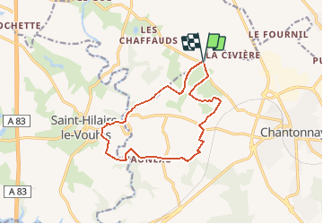
Trail Walking of 12.7 km to be discovered at Pays de la Loire, Vendée, Chantonnay. This trail is proposed by neoroll44.
Description
Départ : Village de la Marzelle Distance : 12,7 km Signalétique : Sentier n°5 - Couleur Noire A découvrir : - Le lavoir de la Culère - Le chêne de la Mainborgère - Le point de vue sur le petit Lay - Le Château de L'Auneau
Positioning
Country:
France
Region :
Pays de la Loire
Department/Province :
Vendée
Municipality :
Chantonnay
Location:
Unknown
Start:(Dec)
Start:(UTM)
646400 ; 5174192 (30T) N.
Comments
Trails nearby
![Trail Other activity Chantonnay - Circuit du lac de l'Angle Guignard - Chantonnay - Photo](https://media.geolcdn.com/t/375/260/ext.jpg?maxdim=2&url=http%3A%2F%2Ffichier1.cirkwi.com%2Fimage%2Fphoto%2Fpoi%2F1300x1300%2F62839%2Ffr%2F0.jpg)
![Other activity Other activity](https://static1.geolcdn.com/sitytour/trail-icons/900.png)
Circuit du lac de l'Angle Guignard - Chantonnay
Other activity
Very easy
Chantonnay,
Pays de la Loire,
Vendée,
France
![](/images/other/stat-length.png)
13.9 km | 17.6 km-effort
Unknown
![](https://static1.geolcdn.com/siteimages/upload/files/16400158638029165_repeat_loop_refresh_sync_direction_icon.png)
Yes
![Trail Walking Chantonnay - GR364-Jour n° 5 - Photo](https://media.geolcdn.com/t/375/260/ext.jpg?maxdim=2&url=https%3A%2F%2Fstatic1.geolcdn.com%2Fsiteimages%2Fupload%2Ffiles%2F1553511878bg_sport_marche.png)
![Walking Walking](https://static1.geolcdn.com/sitytour/trail-icons/101.png)
GR364-Jour n° 5
Walking
Very difficult
Chantonnay,
Pays de la Loire,
Vendée,
France
![](/images/other/stat-length.png)
25 km | 30 km-effort
6h 49min
![](https://static1.geolcdn.com/siteimages/upload/files/16400158638029165_repeat_loop_refresh_sync_direction_icon.png)
No
![Trail Walking Chantonnay - Chantonnay la caillere st hilaire - Photo](https://media.geolcdn.com/t/375/260/ext.jpg?maxdim=2&url=https%3A%2F%2Fstatic1.geolcdn.com%2Fsiteimages%2Fupload%2Ffiles%2F1553511878bg_sport_marche.png)
![Walking Walking](https://static1.geolcdn.com/sitytour/trail-icons/101.png)
Chantonnay la caillere st hilaire
Walking
Medium
Chantonnay,
Pays de la Loire,
Vendée,
France
![](/images/other/stat-length.png)
20 km | 24 km-effort
6h 16min
![](https://static1.geolcdn.com/siteimages/upload/files/16400158638029165_repeat_loop_refresh_sync_direction_icon.png)
No
![Trail Road bike Chantonnay - Plaine de Chantonnay et Château d'eau de la Vendée - Photo](https://media.geolcdn.com/t/375/260/ext.jpg?maxdim=2&url=https%3A%2F%2Fstatic1.geolcdn.com%2Fsiteimages%2Fupload%2Ffiles%2F1524743154velo.jpg)
![Road bike Road bike](https://static1.geolcdn.com/sitytour/trail-icons/201.png)
Plaine de Chantonnay et Château d'eau de la Vendée
Road bike
Medium
Chantonnay,
Pays de la Loire,
Vendée,
France
![](/images/other/stat-length.png)
59 km | 68 km-effort
3h 59min
![](https://static1.geolcdn.com/siteimages/upload/files/16400158638029165_repeat_loop_refresh_sync_direction_icon.png)
Yes
![Trail Walking Chantonnay - Sentier de la Nouette - Chantonnay - Photo](https://media.geolcdn.com/t/375/260/ext.jpg?maxdim=2&url=https%3A%2F%2Fstatic1.geolcdn.com%2Fsiteimages%2Fupload%2Ffiles%2F1553511878bg_sport_marche.png)
![Walking Walking](https://static1.geolcdn.com/sitytour/trail-icons/101.png)
Sentier de la Nouette - Chantonnay
Walking
Difficult
Chantonnay,
Pays de la Loire,
Vendée,
France
![](/images/other/stat-length.png)
12.5 km | 15.2 km-effort
3h 17min
![](https://static1.geolcdn.com/siteimages/upload/files/16400158638029165_repeat_loop_refresh_sync_direction_icon.png)
Yes
![Trail Walking Chantonnay - Circuit du lac de l'Angle Guignard - Chantonnay - Photo](https://media.geolcdn.com/t/375/260/ext.jpg?maxdim=2&url=https%3A%2F%2Fstatic1.geolcdn.com%2Fsiteimages%2Fupload%2Ffiles%2F1553511878bg_sport_marche.png)
![Walking Walking](https://static1.geolcdn.com/sitytour/trail-icons/101.png)
Circuit du lac de l'Angle Guignard - Chantonnay
Walking
Difficult
Chantonnay,
Pays de la Loire,
Vendée,
France
![](/images/other/stat-length.png)
13.9 km | 17.6 km-effort
3h 47min
![](https://static1.geolcdn.com/siteimages/upload/files/16400158638029165_repeat_loop_refresh_sync_direction_icon.png)
Yes
![Trail Walking Chantonnay - Sentier de Puybelliard par Ponsay - Chantonnay - Photo](https://media.geolcdn.com/t/375/260/ext.jpg?maxdim=2&url=https%3A%2F%2Fstatic1.geolcdn.com%2Fsiteimages%2Fupload%2Ffiles%2F1553511878bg_sport_marche.png)
![Walking Walking](https://static1.geolcdn.com/sitytour/trail-icons/101.png)
Sentier de Puybelliard par Ponsay - Chantonnay
Walking
Medium
Chantonnay,
Pays de la Loire,
Vendée,
France
![](/images/other/stat-length.png)
10.3 km | 11.7 km-effort
2h 35min
![](https://static1.geolcdn.com/siteimages/upload/files/16400158638029165_repeat_loop_refresh_sync_direction_icon.png)
Yes
![Trail Walking Chantonnay - Lac de Rochereau - Photo](https://media.geolcdn.com/t/375/260/ext.jpg?maxdim=2&url=https%3A%2F%2Fstatic1.geolcdn.com%2Fsiteimages%2Fupload%2Ffiles%2F1553511878bg_sport_marche.png)
![Walking Walking](https://static1.geolcdn.com/sitytour/trail-icons/101.png)
Lac de Rochereau
Walking
Difficult
Chantonnay,
Pays de la Loire,
Vendée,
France
![](/images/other/stat-length.png)
18.3 km | 21 km-effort
4h 41min
![](https://static1.geolcdn.com/siteimages/upload/files/16400158638029165_repeat_loop_refresh_sync_direction_icon.png)
Yes
![Trail Mountain bike Chantonnay - Vendée Verte 2005 - Photo](https://media.geolcdn.com/t/375/260/ext.jpg?maxdim=2&url=https%3A%2F%2Fstatic1.geolcdn.com%2Fsiteimages%2Fupload%2Ffiles%2F1524743154velo.jpg)
![Mountain bike Mountain bike](https://static1.geolcdn.com/sitytour/trail-icons/202.png)
Vendée Verte 2005
Mountain bike
Very difficult
Chantonnay,
Pays de la Loire,
Vendée,
France
![](/images/other/stat-length.png)
56 km | 70 km-effort
4h 30min
![](https://static1.geolcdn.com/siteimages/upload/files/16400158638029165_repeat_loop_refresh_sync_direction_icon.png)
Yes