![Trail Walking Ndego - Bordure Akagera - Photo](https://media.geolcdn.com/t/1900/400/ext.pjpeg?maxdim=2&url=https%3A%2F%2Fstatic1.geolcdn.com%2Fsiteimages%2Fupload%2Ffiles%2F1553511878bg_sport_marche.png)
Bordure Akagera
camillegoret
User
![Length](/images/other/stat-length.png)
Length
5 km
![Max alt](https://static1.geolcdn.com/siteimages/upload/files/1508320355ic_sort_altitude_max_24dp.png)
Max alt
1649 m
![Uphill gradient](https://static1.geolcdn.com/siteimages/upload/files/1508320355ic_sort_den_pos_24dp.png)
Uphill gradient
123 m
![Km-Effort](/images/other/stat-length.png)
Km-Effort
6.7 km
![Min alt](https://static1.geolcdn.com/siteimages/upload/files/1508320355ic_sort_altitude_min_24dp.png)
Min alt
1589 m
![Downhill gradient](https://static1.geolcdn.com/siteimages/upload/files/1508320355ic_sort_den_neg_24dp.png)
Downhill gradient
122 m
![Boucle](https://static1.geolcdn.com/siteimages/upload/files/16400158638029165_repeat_loop_refresh_sync_direction_icon.png)
Boucle
Yes
Creation date :
2020-02-20 04:35:12.0
Updated on :
2020-02-28 10:32:08.821
![Walking](https://static1.geolcdn.com/sitytour/trail-icons/101.png)
1h10
Difficulty : Unknown
![Scan this QR Code to open this trail in the SityTrail application](https://capi.geolives.com/qq0zvz2zws4bq2lad0pu/sitytour/trails/2348530/qr.png?size=200)
FREE GPS app for hiking
About
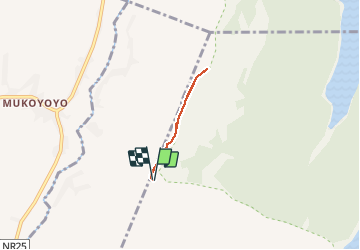
Trail Walking of 5 km to be discovered at East Province, Kayonza District, Ndego. This trail is proposed by camillegoret.
Positioning
Country:
Rwanda
Region :
East Province
Department/Province :
Kayonza District
Municipality :
Ndego
Location:
Unknown
Start:(Dec)
Start:(UTM)
242452 ; 9784257 (36M) S.
Comments
Trails nearby