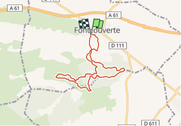
![](/images/other/stat-length.png)
![Trail Walking Fontcouverte - FONCOUVERTE - variante au tracé balisé - Photo](https://media.geolcdn.com/t/1900/400/750a1953-cd23-4c10-9dcb-bf0685597095.jpg&format=pjpeg&maxdim=2)
FONCOUVERTE - variante au tracé balisé
Licianus2
User
![Length](/images/other/stat-length.png)
![Max alt](https://static1.geolcdn.com/siteimages/upload/files/1508320355ic_sort_altitude_max_24dp.png)
![Uphill gradient](https://static1.geolcdn.com/siteimages/upload/files/1508320355ic_sort_den_pos_24dp.png)
![Km-Effort](/images/other/stat-length.png)
![Min alt](https://static1.geolcdn.com/siteimages/upload/files/1508320355ic_sort_altitude_min_24dp.png)
![Downhill gradient](https://static1.geolcdn.com/siteimages/upload/files/1508320355ic_sort_den_neg_24dp.png)
![Boucle](https://static1.geolcdn.com/siteimages/upload/files/16400158638029165_repeat_loop_refresh_sync_direction_icon.png)
![Walking](https://static1.geolcdn.com/sitytour/trail-icons/101.png)
2h06
Difficulty : Easy
![Scan this QR Code to open this trail in the SityTrail application](https://capi.geolives.com/qq0zvz2zws4bq2lad0pu/sitytour/trails/2344006/qr.png?size=200)
FREE GPS app for hiking
About
Trail Walking of 7.8 km to be discovered at Occitania, Aude, Fontcouverte. This trail is proposed by Licianus2.
Description
Cette boucle est une variante du circuit balisé. Pour éviter certaines portions goudronnées et pistes, le tracé s'éloigne par moment du balisage pour y revenir quelque fois.
Pas de difficulté pour cette rando.
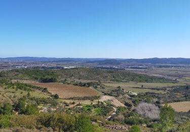
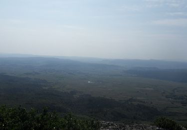
Fontcouverte est un charmant petit village des Corbières. Le nom occitan est Fontcoverta, qui se prononce Founcouberto.
Fontcouverte est blottie au pied d'une petite colline, et comme son nom l'indique, elle existe grâce à des sources, des Fonts.
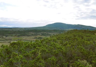
La commune fait partie du vignoble des Monts de l'Alaric.
La source de "Fontcalel"
En occitan "Font dal uelh" (la fontaine de l'oeil). L'oeil, en occitan désigne le trou d'où sortent les eaux d'une source à fleur de terre. Son eau à température constante, 18° été comme hiver, alimente le bassin d'arrosage destiné aux jardins et à la piscine municipale.
Personnellement, j'ai beaucoup de souvenirs de mon adolescence; ma jeunesse des années 50. Tous les ados du canton, son, un jour, passés par là. Lieu de rencontre et de jeux dans cette piscine unique dans le secteur.
La piscine était le rendez-vous des jeunes et des moins jeunes, on peut encore voir le bâtiment des vestiaires sur la gauche, en très mauvais état, dommage.
Positioning
Comments
Trails nearby
![Trail Walking Montbrun-des-Corbières - Montbrun - Photo](https://media.geolcdn.com/t/375/260/ext.jpg?maxdim=2&url=https%3A%2F%2Fstatic1.geolcdn.com%2Fsiteimages%2Fupload%2Ffiles%2F1553511878bg_sport_marche.png)
![Walking Walking](https://static1.geolcdn.com/sitytour/trail-icons/101.png)
Walking
![](/images/other/stat-length.png)
![](https://static1.geolcdn.com/siteimages/upload/files/16400158638029165_repeat_loop_refresh_sync_direction_icon.png)
![Trail Walking Moux - Sur les pas de Roland - Signal d'Alaric - La Caune - Photo](https://media.geolcdn.com/t/375/260/73255cd4-fa7b-4406-9135-61ce5573816a.jpg&format=jpg&maxdim=2)
![Walking Walking](https://static1.geolcdn.com/sitytour/trail-icons/101.png)
Walking
![](/images/other/stat-length.png)
![](https://static1.geolcdn.com/siteimages/upload/files/16400158638029165_repeat_loop_refresh_sync_direction_icon.png)
![Walking Walking](https://static1.geolcdn.com/sitytour/trail-icons/101.png)
Walking
![](/images/other/stat-length.png)
![](https://static1.geolcdn.com/siteimages/upload/files/16400158638029165_repeat_loop_refresh_sync_direction_icon.png)
![Trail Walking Moux - Le signal de l'alaric - Photo](https://media.geolcdn.com/t/375/260/3cf92acc-7cd5-4976-a7a4-9db797ed0e01.jpg&format=jpg&maxdim=2)
![Walking Walking](https://static1.geolcdn.com/sitytour/trail-icons/101.png)
![Trail Walking Conilhac-Corbières - CONILHAC Les Eoliennes - Photo](https://media.geolcdn.com/t/375/260/61a6f362-e725-47d8-be5f-e8d8f9b00380.jpg&format=jpg&maxdim=2)
![Walking Walking](https://static1.geolcdn.com/sitytour/trail-icons/101.png)
Walking
![](/images/other/stat-length.png)
![](https://static1.geolcdn.com/siteimages/upload/files/16400158638029165_repeat_loop_refresh_sync_direction_icon.png)
![Trail Walking Conilhac-Corbières - CONILHAC - lausines - Photo](https://media.geolcdn.com/t/375/260/eabb2449-16e0-4bf7-bb9c-bc1f8dc0926e.jpg&format=jpg&maxdim=2)
![Walking Walking](https://static1.geolcdn.com/sitytour/trail-icons/101.png)
Walking
![](/images/other/stat-length.png)
![](https://static1.geolcdn.com/siteimages/upload/files/16400158638029165_repeat_loop_refresh_sync_direction_icon.png)
![Trail Other activity Fabrezan - Fabrezan - Photo](https://media.geolcdn.com/t/375/260/ext.jpg?maxdim=2&url=https%3A%2F%2Fservices.sitytrail.com%2FGeolivesWS%2FDownloadMedia.ashx%3FTrailID%3D373475%26Media%3Dfix__20141230163405.jpg)
![Other activity Other activity](https://static1.geolcdn.com/sitytour/trail-icons/900.png)
![Trail Running Fontcouverte - Défi de l'Alaric 2012 - Fontcouverte - Photo](https://media.geolcdn.com/t/375/260/ext.jpg?maxdim=2&url=https%3A%2F%2Fservices.sitytrail.com%2FGeolivesWS%2FDownloadMedia.ashx%3FTrailID%3D136878%26Media%3D13545_3.jpg)
![Running Running](https://static1.geolcdn.com/sitytour/trail-icons/103.png)
Running
![](/images/other/stat-length.png)
![](https://static1.geolcdn.com/siteimages/upload/files/16400158638029165_repeat_loop_refresh_sync_direction_icon.png)
![Trail Mountain bike Fontcouverte - Défi de l'Alaric 2012 - Fontcouverte - Photo](https://media.geolcdn.com/t/375/260/ext.jpg?maxdim=2&url=https%3A%2F%2Fservices.sitytrail.com%2FGeolivesWS%2FDownloadMedia.ashx%3FTrailID%3D136877%26Media%3D13545_3.jpg)
![Mountain bike Mountain bike](https://static1.geolcdn.com/sitytour/trail-icons/202.png)
Mountain bike
![](/images/other/stat-length.png)
![](https://static1.geolcdn.com/siteimages/upload/files/16400158638029165_repeat_loop_refresh_sync_direction_icon.png)
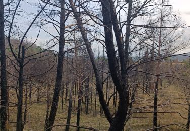
Zone incendiée normalement interdite aux piétons.