![](/images/other/stat-length.png)
![Trail Walking Jaca - Peña de Oroel - Photo](https://media.geolcdn.com/t/1900/400/36fa8903-e8ea-4e8f-9a1d-eca14e59e06c.jpg&format=pjpeg&maxdim=2)
Peña de Oroel
bedous
User
![Length](/images/other/stat-length.png)
Length
8.4 km
![Max alt](https://static1.geolcdn.com/siteimages/upload/files/1508320355ic_sort_altitude_max_24dp.png)
Max alt
1756 m
![Uphill gradient](https://static1.geolcdn.com/siteimages/upload/files/1508320355ic_sort_den_pos_24dp.png)
Uphill gradient
575 m
![Km-Effort](/images/other/stat-length.png)
Km-Effort
16.1 km
![Min alt](https://static1.geolcdn.com/siteimages/upload/files/1508320355ic_sort_altitude_min_24dp.png)
Min alt
1186 m
![Downhill gradient](https://static1.geolcdn.com/siteimages/upload/files/1508320355ic_sort_den_neg_24dp.png)
Downhill gradient
577 m
![Boucle](https://static1.geolcdn.com/siteimages/upload/files/16400158638029165_repeat_loop_refresh_sync_direction_icon.png)
Boucle
Yes
Creation date :
2020-02-21 09:36:09.616
Updated on :
2020-02-22 17:11:38.911
![Walking](https://static1.geolcdn.com/sitytour/trail-icons/101.png)
4h14
Difficulty : Medium
![Scan this QR Code to open this trail in the SityTrail application](https://capi.geolives.com/qq0zvz2zws4bq2lad0pu/sitytour/trails/2341783/qr.png?size=200)
FREE GPS app for hiking
About
Trail Walking of 8.4 km to be discovered at Aragon, Huesca, Jaca. This trail is proposed by bedous.
Description
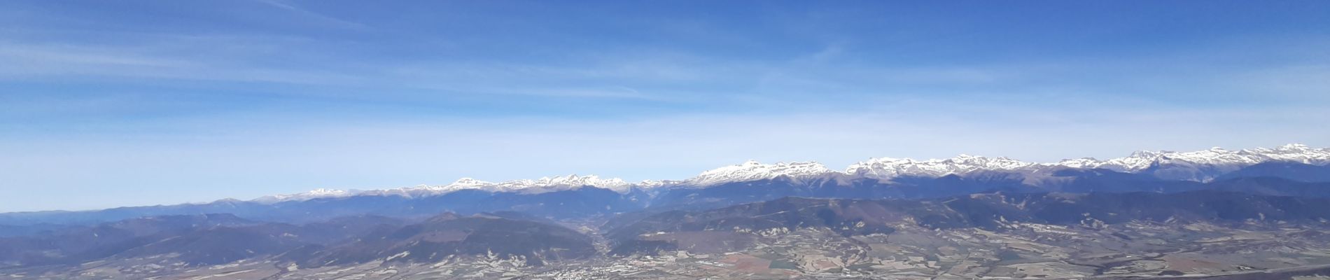
Montée par un chemin sinueux, ombragé, jusqu'à la croix au sommet de la peña. Effort récompensé par une magnifique vue sur la vallée du fleuve Aragon, la ville de Jaca et la chaine des Pyrénées. On peut en cherchant "un peu" trouver au bout du chemin sinueux et au pied de la petite falaise, deux puits à neige. (Réserve de glace pour nos anciens)
Positioning
Country:
Spain
Region :
Aragon
Department/Province :
Huesca
Municipality :
Jaca
Location:
Unknown
Start:(Dec)
Start:(UTM)
702671 ; 4711253 (30T) N.
Comments
Trails nearby
![Trail Walking Jaca - esp_oroel_courte - Photo](https://media.geolcdn.com/t/375/260/ext.jpg?maxdim=2&url=https%3A%2F%2Fstatic1.geolcdn.com%2Fsiteimages%2Fupload%2Ffiles%2F1553511878bg_sport_marche.png)
![Walking Walking](https://static1.geolcdn.com/sitytour/trail-icons/101.png)
![Trail Walking Jaca - 17.05.17 Jaca Arrès - Photo](https://media.geolcdn.com/t/375/260/ext.jpg?maxdim=2&url=https%3A%2F%2Fstatic1.geolcdn.com%2Fsiteimages%2Fupload%2Ffiles%2F1553511878bg_sport_marche.png)
![Walking Walking](https://static1.geolcdn.com/sitytour/trail-icons/101.png)
17.05.17 Jaca Arrès
Walking
Very difficult
Jaca,
Aragon,
Huesca,
Spain
![](/images/other/stat-length.png)
26 km | 30 km-effort
6h 35min
![](https://static1.geolcdn.com/siteimages/upload/files/16400158638029165_repeat_loop_refresh_sync_direction_icon.png)
No
![Trail Walking Jaca - esp_Oroel_1 - Photo](https://media.geolcdn.com/t/375/260/ext.jpg?maxdim=2&url=https%3A%2F%2Fstatic1.geolcdn.com%2Fsiteimages%2Fupload%2Ffiles%2F1553511878bg_sport_marche.png)
![Walking Walking](https://static1.geolcdn.com/sitytour/trail-icons/101.png)
![Trail Walking Jaca - esp_oroel_courte - Photo](https://media.geolcdn.com/t/375/260/ext.jpg?maxdim=2&url=https%3A%2F%2Fstatic1.geolcdn.com%2Fsiteimages%2Fupload%2Ffiles%2F1553511878bg_sport_marche.png)
![Walking Walking](https://static1.geolcdn.com/sitytour/trail-icons/101.png)
![Trail Walking Jaca - esp_oroel_cueva - Photo](https://media.geolcdn.com/t/375/260/ext.jpg?maxdim=2&url=https%3A%2F%2Fstatic1.geolcdn.com%2Fsiteimages%2Fupload%2Ffiles%2F1553511878bg_sport_marche.png)
![Walking Walking](https://static1.geolcdn.com/sitytour/trail-icons/101.png)
![Trail Cycle Jaca - Jaca Espagne 2016 - Photo](https://media.geolcdn.com/t/375/260/ext.jpg?maxdim=2&url=https%3A%2F%2Fstatic1.geolcdn.com%2Fsiteimages%2Fupload%2Ffiles%2F1524743154velo.jpg)
![Cycle Cycle](https://static1.geolcdn.com/sitytour/trail-icons/200.png)
![Trail sport Jaca - pena-oroel - Photo](https://media.geolcdn.com/t/375/260/ext.jpg?maxdim=2&url=https%3A%2F%2Fsecurestorage.geolives.com%2Fsitytour%2Ftrail-bg%2Fdefault.jpg)
![Trail Walking Jaca - camino frances tramo aragones etapa 02a variante abay ascara - Photo](https://media.geolcdn.com/t/375/260/ext.jpg?maxdim=2&url=https%3A%2F%2Fstatic1.geolcdn.com%2Fsiteimages%2Fupload%2Ffiles%2F1553511878bg_sport_marche.png)
![Walking Walking](https://static1.geolcdn.com/sitytour/trail-icons/101.png)
camino frances tramo aragones etapa 02a variante abay ascara
Walking
Very easy
Jaca,
Aragon,
Huesca,
Spain
![](/images/other/stat-length.png)
17.2 km | 20 km-effort
Unknown
![](https://static1.geolcdn.com/siteimages/upload/files/16400158638029165_repeat_loop_refresh_sync_direction_icon.png)
No