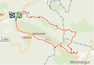
![](/images/other/stat-length.png)
Sentier cathare - Château de Montsegur
toutankhcarton
User GUIDE
![Length](/images/other/stat-length.png)
![Max alt](https://static1.geolcdn.com/siteimages/upload/files/1508320355ic_sort_altitude_max_24dp.png)
![Uphill gradient](https://static1.geolcdn.com/siteimages/upload/files/1508320355ic_sort_den_pos_24dp.png)
![Km-Effort](/images/other/stat-length.png)
![Min alt](https://static1.geolcdn.com/siteimages/upload/files/1508320355ic_sort_altitude_min_24dp.png)
![Downhill gradient](https://static1.geolcdn.com/siteimages/upload/files/1508320355ic_sort_den_neg_24dp.png)
![Boucle](https://static1.geolcdn.com/siteimages/upload/files/16400158638029165_repeat_loop_refresh_sync_direction_icon.png)
![Walking](https://static1.geolcdn.com/sitytour/trail-icons/101.png)
4h48
Difficulty : Medium
![Scan this QR Code to open this trail in the SityTrail application](https://capi.geolives.com/qq0zvz2zws4bq2lad0pu/sitytour/trails/2341718/qr.png?size=200)
FREE GPS app for hiking
About
Trail Walking of 12.6 km to be discovered at Occitania, Ariège, Montferrier. This trail is proposed by toutankhcarton.
Description
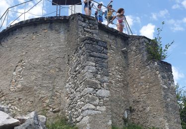
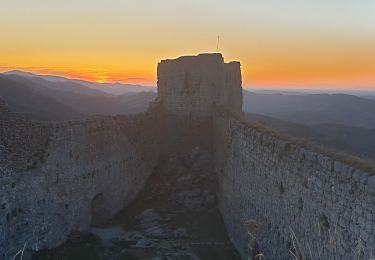
Au départ de Montferrier, emprunter le GR 107 puis 307 jusqu'au château de Montsegur. Château cathare construit en 1206. (entrée payante à compter de mars)
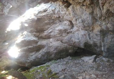
Retour par GR 78. A la balise 863, prendre à gauche en coupant dans les sous-bois. Attention itinéraire non balisé jusqu'à la Passette où l'on rejoint une piste.
Positioning
Comments
Trails nearby
![Trail Walking Montferrier - Pic de Saint-Barthélémy - Pla de la Galine - Photo](https://media.geolcdn.com/t/375/260/ext.jpg?maxdim=2&url=https%3A%2F%2Fservices.sitytrail.com%2FGeolivesWS%2FDownloadMedia.ashx%3FTrailID%3D107183%26Media%3D12034_5.jpg)
![Walking Walking](https://static1.geolcdn.com/sitytour/trail-icons/101.png)
Walking
![](/images/other/stat-length.png)
![](https://static1.geolcdn.com/siteimages/upload/files/16400158638029165_repeat_loop_refresh_sync_direction_icon.png)
![Trail Electric bike Lavelanet - Lavelanet Ste Colombe lac Montbel retour Laroque - Photo](https://media.geolcdn.com/t/375/260/4c93721d-d109-4910-92f4-e8bb9c7e7c78.jpg&format=jpg&maxdim=2)
![Electric bike Electric bike](https://static1.geolcdn.com/sitytour/trail-icons/205.png)
Electric bike
![](/images/other/stat-length.png)
![](https://static1.geolcdn.com/siteimages/upload/files/16400158638029165_repeat_loop_refresh_sync_direction_icon.png)
![Trail Walking Roquefixade - roquefixade - Photo](https://media.geolcdn.com/t/375/260/a4ee5e64-4a22-4a44-afa9-4440a817a12f.jpg&format=jpg&maxdim=2)
![Walking Walking](https://static1.geolcdn.com/sitytour/trail-icons/101.png)
![Trail Walking Montferrier - découverte du château de montsegur et du village par montferroer - Photo](https://media.geolcdn.com/t/375/260/dbb91943-13a6-421f-97eb-22e28af831f5.jpg&format=jpg&maxdim=2)
![Walking Walking](https://static1.geolcdn.com/sitytour/trail-icons/101.png)
Walking
![](/images/other/stat-length.png)
![](https://static1.geolcdn.com/siteimages/upload/files/16400158638029165_repeat_loop_refresh_sync_direction_icon.png)
![Trail Walking Lavelanet - Camping Village des Bons-Hommes pour balade-grillade - Photo](https://media.geolcdn.com/t/375/260/e5db2f0d-f510-4eba-beea-b49938a14807.jpg&format=jpg&maxdim=2)
![Walking Walking](https://static1.geolcdn.com/sitytour/trail-icons/101.png)
Walking
![](/images/other/stat-length.png)
![](https://static1.geolcdn.com/siteimages/upload/files/16400158638029165_repeat_loop_refresh_sync_direction_icon.png)
![Trail Walking Montségur - 03 et 04 - MONTSEGUR COMUS SORGEAT - Chemin des Bons-Hommes GR107 - Photo](https://media.geolcdn.com/t/375/260/695e8c03-f8ca-4a73-a2fc-4cbbe8211d15.jpg&format=jpg&maxdim=2)
![Walking Walking](https://static1.geolcdn.com/sitytour/trail-icons/101.png)
Walking
![](/images/other/stat-length.png)
![](https://static1.geolcdn.com/siteimages/upload/files/16400158638029165_repeat_loop_refresh_sync_direction_icon.png)
![Trail Walking Montségur - la Frau - Photo](https://media.geolcdn.com/t/375/260/ext.jpg?maxdim=2&url=https%3A%2F%2Fservices.sitytrail.com%2FGeolivesWS%2FDownloadMedia.ashx%3FTrailID%3D1026292%26Media%3Dfix__20180821154103.jpg)
![Walking Walking](https://static1.geolcdn.com/sitytour/trail-icons/101.png)
![Trail Walking Lavelanet - BOUCLE Ste Rufine, Raissac, Péreille d'en Bas et Haut, retour Cambière Bensa - Photo](https://media.geolcdn.com/t/375/260/ext.jpg?maxdim=2&url=https%3A%2F%2Fservices.sitytrail.com%2FGeolivesWS%2FDownloadMedia.ashx%3FTrailID%3D816622%26Media%3Dfix__20170824122820.jpg)
![Walking Walking](https://static1.geolcdn.com/sitytour/trail-icons/101.png)
Walking
![](/images/other/stat-length.png)
![](https://static1.geolcdn.com/siteimages/upload/files/16400158638029165_repeat_loop_refresh_sync_direction_icon.png)
![Trail Snowshoes Montferrier - Mont d'Olmes - le Planas - Photo](https://media.geolcdn.com/t/375/260/ext.jpg?maxdim=2&url=https%3A%2F%2Fservices.sitytrail.com%2FGeolivesWS%2FDownloadMedia.ashx%3FTrailID%3D696670%26Media%3Dfix__20170211144313.jpg)
![Snowshoes Snowshoes](https://static1.geolcdn.com/sitytour/trail-icons/504.png)
Snowshoes
![](/images/other/stat-length.png)
![](https://static1.geolcdn.com/siteimages/upload/files/16400158638029165_repeat_loop_refresh_sync_direction_icon.png)